Remote sensing image scene classification method based on multi-similarity measurement deep learning

A similarity measurement and remote sensing image technology, applied in the field of remote sensing image scene classification, can solve the problems of inability to fully express the differences between different classes, single similarity, redundant information, etc.

Active Publication Date: 2020-09-29
HOHAI UNIV
View PDF4 Cites 13 Cited by
  • Summary
  • Abstract
  • Description
  • Claims
  • Application Information

AI Technical Summary

Problems solved by technology

However, considering that the comparison loss is based on a single sample pair of sampling, the relationship between the overall sample and the local sample is not considered, and a fixed threshold is also used, which has certain limitations for multi-classification problems.
[0009] (1) Feature extraction is complex and inefficient: Traditional classification methods need to use different image feature extraction algorithms to extract various types of features of images, and the process is cumbersome and complicated
At the same time, these classification algorithms generally only have a shallow structure, and the learned expression features cannot fully cover remote sensing image information, there is redundant information, and their classification performance and generalization ability are obviously insufficient;
[0010] (2) The training network optimization loss is single: the existing remote sensing image scene classification methods usually only rely on the cross-entropy loss to optimize the weight parameters. When the scene image is too complex and has many categories, the cross-entropy loss cannot fully express the differences between different classes. , thus weakening the classification performance
[0011] (3) The existing basic methods of metric learning mostly use a single similarity, do not consider the relationship between the local and the whole, and focus on local sampling samples; at the same time, the method of weighting between sample pairs containing different amounts of information mostly adopts a fixed Weight value, i.e. hard weighting method, lacks flexibility

Method used


Image

  • Remote sensing image scene classification method based on multi-similarity measurement deep learning
  • Remote sensing image scene classification method based on multi-similarity measurement deep learning
  • Remote sensing image scene classification method based on multi-similarity measurement deep learning

Examples


Embodiment Construction

[0081] The technical solutions of the present invention will be further described below in conjunction with the accompanying drawings and embodiments.

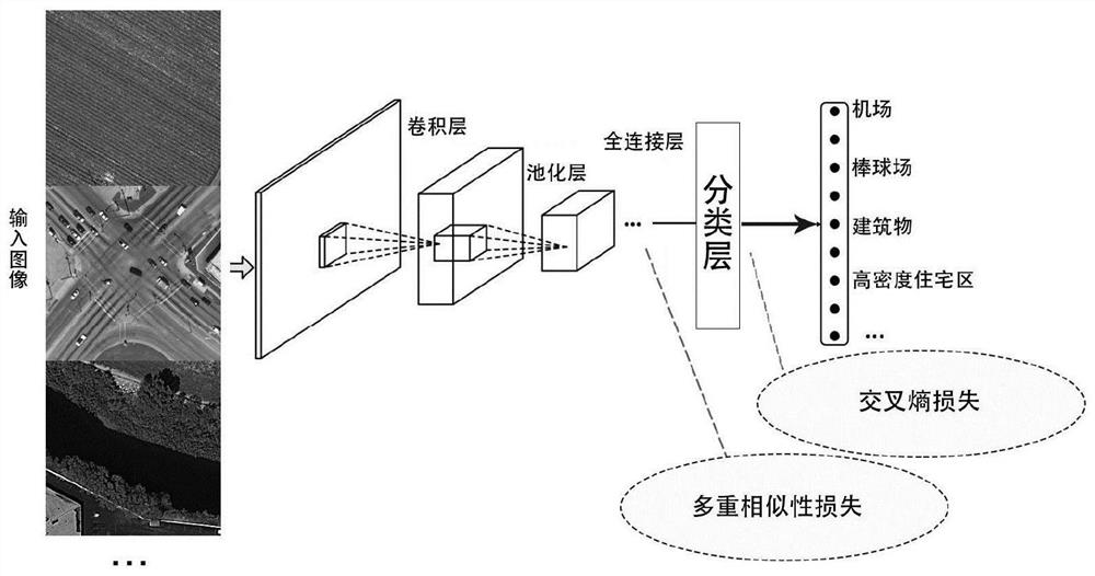
[0082] Such as figure 1 Shown, technical scheme of the present invention is described in further detail as follows:

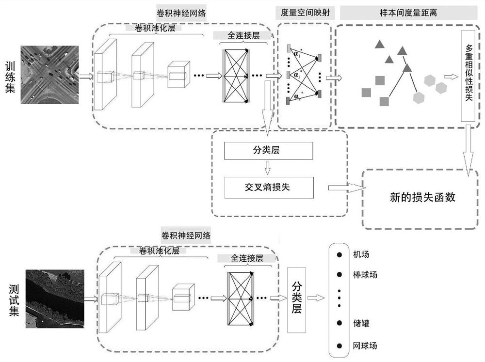
[0083] (1) A deep convolutional neural network is used to train remote sensing scene images, and a multiple similarity loss is added to the traditional cross-entropy loss to form a new loss function. The multiple similarity loss item maps the extracted fully connected features to the metric distance space, calculates and constrains the metric distance between input image samples, so that the network model is more discriminative, and can effectively classify remote sensing scene images.

[0084] (1.1) Build X = {xi |i=1,2,...,N} is the input remote sensing image data sample, Y={y i |i=1,2,...,N} is the category label set corresponding to the input remote sensing image data sample, y i ∈ R c Indicates the lab...


PUM


Abstract

The invention discloses a remote sensing image scene classification method based on multi-similarity measurement deep learning. The method comprises the following steps: firstly, carrying out classification training on a remote sensing image scene by utilizing a deep convolutional network, and taking the output of the last full connection layer as the characteristics of a remote sensing scene image; secondly, introudicng knowledge of deep metric learning, providing a new loss function, and adding multiple similarity loss items on the basis of traditional cross entropy loss items. According tothe multi-similarity loss item, the extracted full-connection features are mapped to the measurement distance space, and the measurement distance between the input image samples is calculated and constrained, so that the network model is more distinctive, and remote sensing scene images can be more effectively classified. According to the method, the convolutional neural network is utilized to perform feature extraction on the remote sensing image, the deep features obtained through learning cover complete information and have relatively high discrimination, and the features are combined withmetric learning, so that good classification performance can be achieved.

Description

technical field [0001] The invention belongs to the field of image processing, in particular to a remote sensing image scene classification method based on multiple similarity measure deep learning. Background technique [0002] Different ground features have different electromagnetic spectrum characteristics, and image data that record the spectrum and time-space characteristics of these ground features in real time are called remote sensing images. Remote sensing image classification usually distinguishes the category labels of ground objects according to the unique electromagnetic spectrum characteristics of different ground objects on the image. At present, remote sensing image classification is one of the important research directions in the field of remote sensing, and it is widely used in many application fields such as geological survey, disaster monitoring, traffic supervision and global temperature change. Therefore, in-depth research on remote sensing image class...

Claims


Application Information

Patent Timeline
Patent Type & Authority Applications(China)
IPC IPC(8): G06K9/00G06K9/62G06N3/04G06N3/08
CPCG06N3/08G06V20/13G06N3/047G06N3/045G06F18/2415G06F18/241
Inventor 王鑫张之露吕国芳石爱业
Owner HOHAI UNIV
Why Eureka
Try Eureka