Karst detection method combining three geophysical prospecting methods and two geological methods

A karst and geological technology, which is used in electrical/magnetic detection, geophysical measurement, and measurement devices for logging records. It can solve problems such as detection depth, identification resolution, interpretation accuracy, etc. The effect of multiple solutions, improved accuracy, and reduced drilling risk

Active Publication Date: 2020-10-16
四川省自然资源投资集团物探勘查院有限公司
View PDF6 Cites 6 Cited by
  • Summary
  • Abstract
  • Description
  • Claims
  • Application Information

AI Technical Summary

Problems solved by technology

At present, in the existing technologies at home and abroad, a single geological survey method, geophysical exploration method or simple geophysical prospecting + geological method are mostly used for karst exploration before shale gas drilling, and there are still limitations in detection depth, identification resolution and interpretation accuracy. defect

Method used


Image

  • Karst detection method combining three geophysical prospecting methods and two geological methods
  • Karst detection method combining three geophysical prospecting methods and two geological methods
  • Karst detection method combining three geophysical prospecting methods and two geological methods

Examples


Embodiment 1

[0047] Embodiment 1 provides a kind of karst detection method that combines three kinds of geophysical prospecting methods and two kinds of geological methods, including:

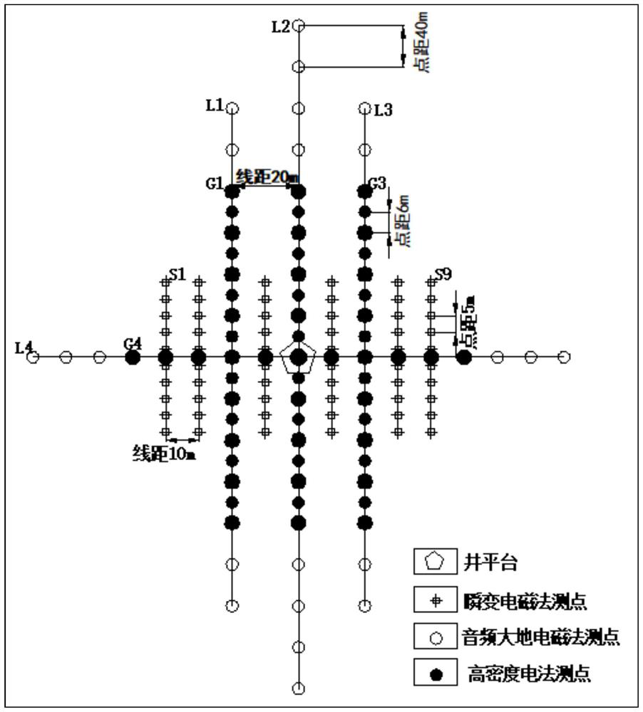
[0048] Step 1, centering on the detection target, plan the survey area, and carry out engineering geological survey and hydrogeological survey in the survey area to obtain comprehensive geological information of the research area;

[0049] Step 2: Divide the underground space of the detection target into the first buried depth interval, the second buried depth interval and the third buried depth interval from shallow to deep, and design a geophysical data integrated observation system based on the engineering geological information and hydrogeological information The geophysical data integration observation system includes a high-density electrical observation system for detecting the first buried depth interval, a transient electromagnetic observation system for detecting the second buried depth interval, a...


PUM


Abstract

The invention relates to the field of shale gas pre-drilling exploration, in particular to a karst detection method combining three geophysical prospecting methods and two geological methods. The karst detection method comprises the steps that S1, engineering geology and hydrogeology reconnaissance is carried out to obtain comprehensive geological information; S2, the underground space is dividedinto a first burial depth interval, a second burial depth interval and a third burial depth interval from shallow to deep, and a geophysical prospecting data integrated observation system is designed;S3, high-density electrical method, TEM and AMT data acquisition and data processing inversion are respectively performed according to the geophysical prospecting data integrated observation system to obtain a first apparent resistivity profile, a second apparent resistivity profile and a third apparent resistivity profile; 4, karst development ranges in the first burial depth interval, the second burial depth interval and the third burial depth interval are determined; and 5, the shallow karst development range of the third burial depth interval is determined by integrating the karst development ranges in the first, second and third burial depth intervals and the comprehensive geological information. According to the method, the problem that the detection depth is limited by adopting a single geophysical prospecting method is solved, meanwhile, advantage complementation of multiple geophysical prospecting methods is achieved, and the risk identification precision is improved.

Description

technical field [0001] The invention relates to the field of pre-drilling exploration of shale gas, in particular to a karst detection method combining three geophysical prospecting methods and two geological methods. Background technique [0002] China's shale gas is mainly located in the Sichuan Basin, which accounts for 60% of the country's total output. Currently, shale gas production areas are mainly concentrated in southern Sichuan. Large-scale development of shale gas began in 2014, and 3 billion cubic meters of shale gas was built in 2016. production capacity. The "Shale Gas Exploration and Development Experimental Area in Southern Sichuan Province" and the "Changning-Weiyuan National Shale Gas Demonstration Area in Sichuan Province" have become national-level experimental areas and demonstration areas. [0003] The southern part of Sichuan Province belongs to the middle-alpine area, with deep cuts and large elevation differences. The shale gas development target la...

Claims


Application Information

Patent Timeline
Patent Type & Authority Applications(China)
IPC IPC(8): G01V3/18G01V3/28G01V3/38
CPCG01V3/18G01V3/28G01V3/38
Inventor 张光大余长恒贾建超王安平张旭林杨宇宁刘磊李易王强
Owner 四川省自然资源投资集团物探勘查院有限公司
Why Eureka
Try Eureka