
Urban functional area quantitative identification method based on open source geospatial vector data

A technology of vector data and city functions, applied in the field of geospatial data applications, can solve problems such as inaccurate identification

Pending Publication Date: 2020-10-20
WUHAN UNIV
View PDF0 Cites 1 Cited by
  • Summary
  • Abstract
  • Description
  • Claims
  • Application Information

AI Technical Summary

Problems solved by technology

[0007] Therefore, the present invention adopts different open-source geospatial vector data as analysis data sources, uses national standards as functional identification references, and establishes a complete frame and method for accurate quantitative identification of functional areas under different types of urban blocks to solve or At least partially solve the technical problem of insufficient identification in the methods in the prior art

Method used


Image

  • Urban functional area quantitative identification method based on open source geospatial vector data
  • Urban functional area quantitative identification method based on open source geospatial vector data
  • Urban functional area quantitative identification method based on open source geospatial vector data

Examples


Embodiment Construction

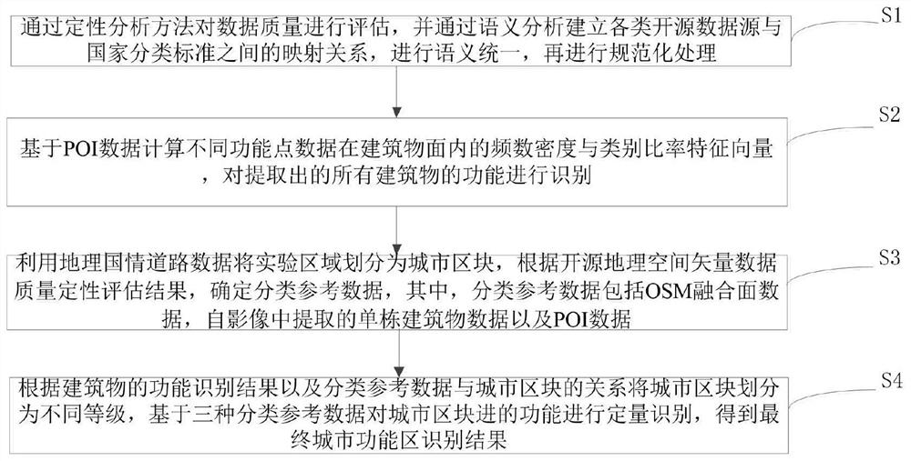
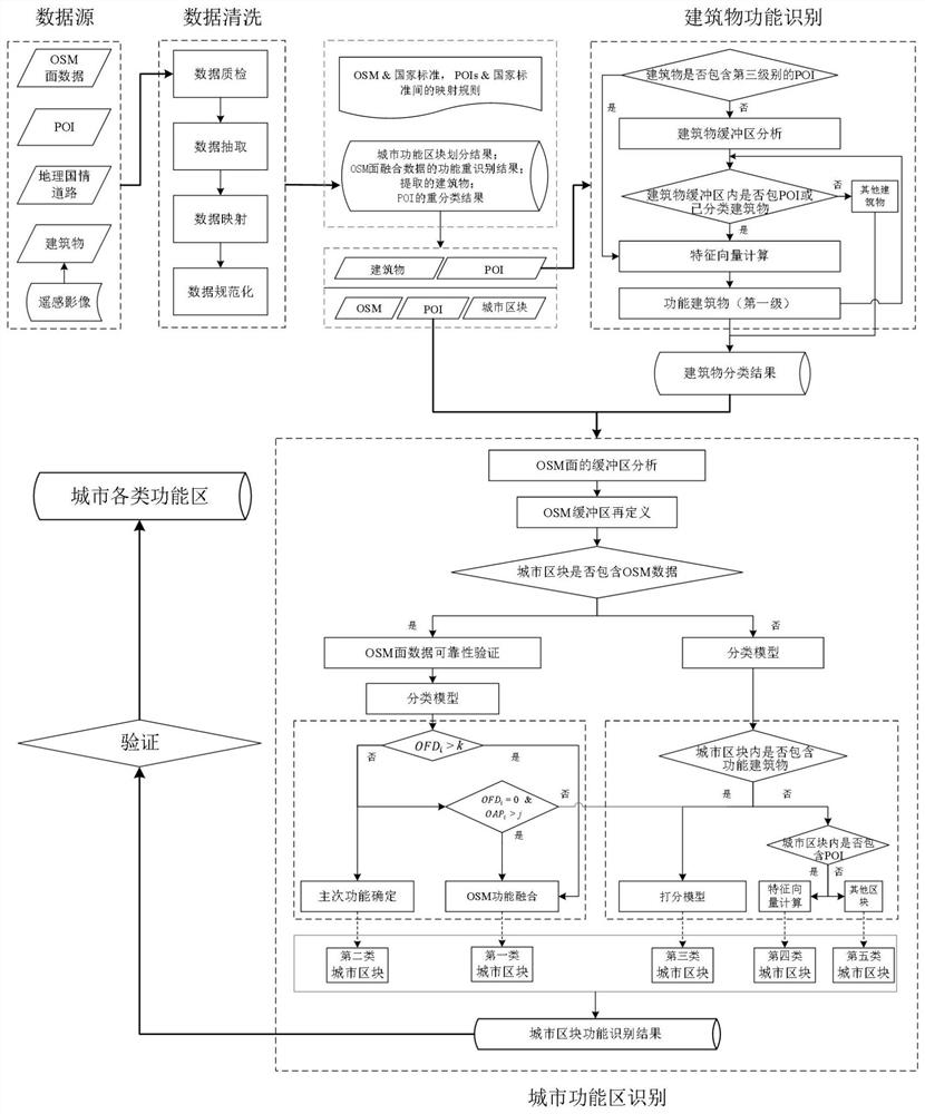
[0064] The present invention proposes a quantitative identification method of urban functional areas based on open-source geographic space vector data. The method first evaluates the data quality through qualitative analysis, and establishes the relationship between various open-source data sources and national classification standards through semantic analysis. The mapping relationship, formulate the fusion strategy. In this method, the research unit is divided by geographical road data, and the classification reference data is composed of three parts: OSM fusion surface data, single building data extracted from images, and POI data. By judging the spatial relationship between the urban division blocks and the classification reference data, the city blocks are divided into 5 categories: when the city block contains the OSM surface, by calculating the ratio of the number of POIs in the OSM surface and the block and the OSM and the block The area ratio of the first and second t...


PUM


Abstract

The invention discloses an urban functional area quantitative identification method based on open source geospatial vector data. According to the method, a framework system and a technical process foridentifying an urban functional area under the guidance of open source data are established. Firstly, data quality is evaluated through a qualitative analysis method, a mapping relation between various open source data sources and national classification standards is established through semantic analysis, and a fusion strategy is formulated. In the method, a research unit is divided by geographicnational condition road data, and classification reference data is composed of three parts: OSM fusion surface data, single building data extracted from an image and POI data. The city blocks are divided into five classes by judging the spatial relationship between the city division blocks and the classification reference data. The method provided by the invention can improve the category extraction precision and the identification precision.

Description

technical field [0001] The invention relates to the technical field of geospatial data applications, in particular to a method for quantitatively identifying urban functional areas based on open source geospatial vector data. Background technique [0002] Urban functional areas are of great significance to urban management, urban renewal, and research on the development and planning of the third world. In just a few decades, the world has made great achievements in promoting urbanization, but it has also brought many problems, such as urban sprawl and population explosion, especially in developing countries, extensive land use and uneven The allocation of urban areas has become the main factor restricting economic development, making the optimization of urban construction land use has become a top priority, and grasping the real status quo of the distribution and structure of urban functional areas is precisely an important prerequisite for optimization. Therefore, how to q...

Claims


Application Information

Patent Timeline
IPC IPC(8): G06F16/29G06F40/30G06K9/62G06Q50/26
CPCG06F40/30G06F16/29G06Q50/26G06F18/25G06F18/241Y02A30/60
Inventor 眭海刚杜卓童李强
Owner WUHAN UNIV
Learn More