Coastal wetland high-resolution month-by-month soil salinity monitoring method and coastal wetland high-resolution month-by-month soil salinity monitoring system
A high-resolution, soil-based technology, applied in the field of soil salinity monitoring, can solve complex and difficult problems and achieve the effect of improving prediction accuracy
- Summary
- Abstract
- Description
- Claims
- Application Information
AI Technical Summary
Problems solved by technology
Method used
Image

Examples
Embodiment 1
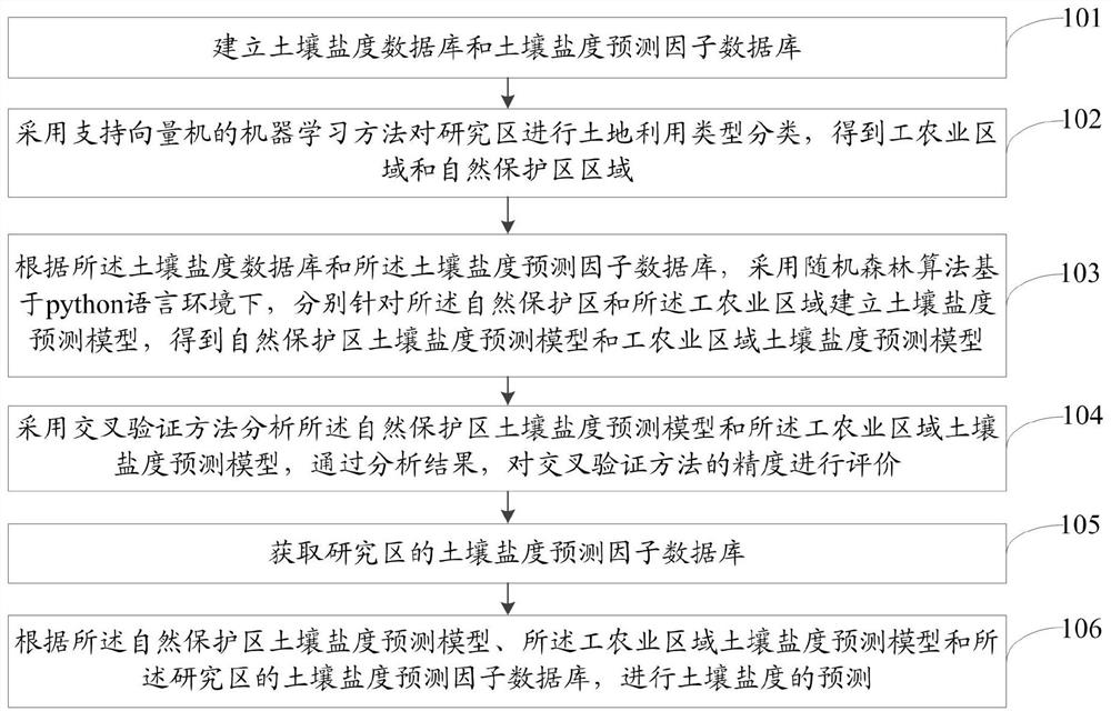
[0103] 1. Taking the nature reserve at the mouth of the Yellow River in Dongying City as the research area, predict the change of soil salinity.
[0104] Implementation steps:
[0105] Step 1. Establish the database of 0-20cm soil salinity data and soil salinity predictors: Obtain basic data related to soil salinity through field investigation and preparation, and establish a soil salinity database based on the ArcGIS platform; use statistical surveys, remote sensing and geographic information systems Obtain multi-source joint data sets, collect soil salinity predictors, and establish a database of soil salinity predictors.
[0106] Among them, the method of obtaining soil salinity data is to use a ring knife with a diameter of 10cm to take five soil samples in a 30m*30m quadrat according to the five-point sampling method, mix them into one soil sample, and use a conductivity meter in the laboratory Measure the salinity value SAL in the system, record the sampling time and th...
Embodiment 2
[0124] Taking the industrial and agricultural area of the mouth of the Yellow River in Dongying City as the research area, the change of soil salinity is predicted.
[0125] Implementation steps:
[0126]First, establish a database of 0-20cm soil salinity data and soil salinity predictors: obtain basic data related to soil salinity through field investigation and preparation, and establish a soil salinity database based on the ArcGIS platform; use statistical surveys, remote sensing and geographic information systems Obtain multi-source joint data sets, collect soil salinity predictors, and establish a database of soil salinity predictors.
[0127] Among them, the soil salinity data acquisition method is to use a 10cm-diameter ring knife to take five soil samples in a 30m*30m quadrat according to the five-point sampling method, mix them into one soil sample, and use a conductivity meter in the laboratory Measure the salinity value SAL in the system, record the sampling time...
PUM
 Abstract
Description
Claims
Application Information