Plateau type unmanned aerial vehicle aviation wide-area geological survey system

A geological survey and unmanned aerial vehicle technology, applied in the direction of unmanned aerial vehicles, rotorcraft, motor vehicles, etc., can solve the problems of large manpower and time, life support difficulties, consumption, etc., to improve effectiveness and improve operation efficiency , the effect of reducing the likelihood

Inactive Publication Date: 2020-11-13
深圳市广域鹏翔研究开发有限公司
View PDF6 Cites 0 Cited by
  • Summary
  • Abstract
  • Description
  • Claims
  • Application Information

AI Technical Summary

Problems solved by technology

[0002] The wide-area electromagnetic geological survey technology has been recognized and verified by the industry. It can effectively measure the geological structure and mineral deposit distribution at a depth of several kilometers below the surface. Perform inversion analysis on the data collected by the sensor to know the geotechnical structure below the surface. In the plateau environment, the operation mode of hand-carrying on the shoulder limits the operation range and operation efficiency of the wide-area survey technology. The survey team is faced with heavy transportation. Burden, the sensor and many auxiliary equipment must be transported to the measurement point, and the method of carrying people and animals must be adopted when there is no traffic. Usually, the measurement points are dense, and the sensors and auxiliary equipment on the back need to consume a lot of manpower and time. Not only that , many uninhabited areas, high altitude hypoxia, no supplies, life support is difficult, and this kind of operation method cannot cope

Method used


Image

  • Plateau type unmanned aerial vehicle aviation wide-area geological survey system
  • Plateau type unmanned aerial vehicle aviation wide-area geological survey system
  • Plateau type unmanned aerial vehicle aviation wide-area geological survey system

Examples


Embodiment Construction

[0015] The present invention will be further elaborated below in conjunction with the accompanying drawings and specific embodiments.

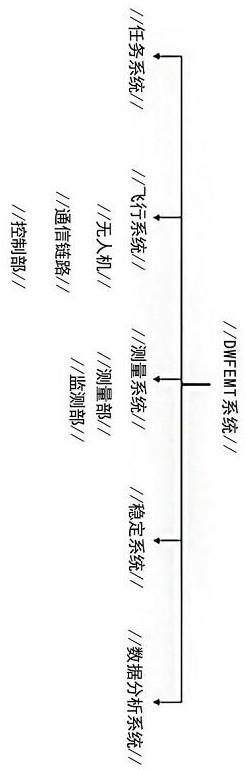
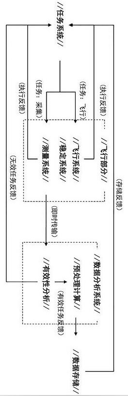
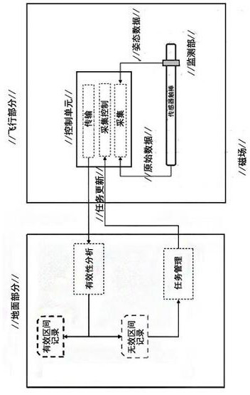
[0016] Such as Figure 1-6 As shown, a plateau prototype unmanned aerial vehicle wide-area geological survey system includes a mission system, a flight system, a measurement system, a stabilization system, and a data analysis system. The mission system performs mission planning for different survey target areas, and resources Management and task supervision, and issue flight tasks to the flight system, and at the same time receive survey effectiveness feedback from the measurement system. The flight system is composed of drones, communication links and ground control stations to complete flight aerial survey tasks. The measurement system is a wide-area The core functional components of the geomagnetic survey include the measurement department and the monitoring department, both of which operate independently to achieve effective data collectio...


PUM


Abstract

The invention discloses a plateau type unmanned aerial vehicle aviation wide-area geological survey system comprising a task system, a flight system, a measuring system, a stabilization system, and adata analysis system. The task system carries out task planning for different survey target areas, resource management and task supervision, issues a flight task to the flight system; meanwhile, survey effectiveness feedback of the measuring s system is received; the flight system is composed of an unmanned aerial vehicle, a communication link and a ground control station so as to complete a flight aerial survey task; the measuring s system is a core functional part of wide-area geomagnetic survey and comprises a measurement part and a monitoring part, and the measurement part and the monitoring part operate independently so as to realize effective data acquisition. The plateau type unmanned aerial vehicle aviation wide-area geomagnetic survey system is called a DWFEMT system for short. The design is reasonable; according to the DWFEMT system, the unmanned aerial vehicle is used as an operation carrier, heavy labor of manual transportation and manual hiking measurement point positioning is avoided, and the operation efficiency is greatly improved.

Description

technical field [0001] The invention relates to a plateau prototype unmanned aerial vehicle wide-area geological survey system. Background technique [0002] The wide-area electromagnetic geological survey technology has been recognized and verified by the industry. It can effectively measure the geological structure and mineral deposit distribution at a depth of several kilometers below the surface. Perform inversion analysis on the data collected by the sensor to know the geotechnical structure below the surface. In the plateau environment, the operation mode of hand-carrying on the shoulder limits the operation range and operation efficiency of the wide-area survey technology. The survey team is faced with heavy transportation. Burden, the sensor and many auxiliary equipment must be transported to the measurement point, and the method of carrying people and animals must be adopted when there is no traffic. Usually, the measurement points are dense, and the sensors and aux...

Claims


Application Information

Patent Timeline
Patent Type & Authority Applications(China)
IPC IPC(8): B64C27/08B64C25/62B64D27/24B64D27/26B64D43/00B64D43/02B64D47/00G01D21/02
CPCB64C27/08B64C25/62B64D27/24B64D27/26B64D43/00B64D43/02B64D47/00G01D21/02B64U50/19B64U10/10B64U2101/00
Inventor 王泽深任禹桥梁维天凌帆
Owner 深圳市广域鹏翔研究开发有限公司
Why Eureka
Try Eureka