A low-latency high-definition AR multi-channel navigation system

A navigation system and low-latency technology, applied in the field of AR navigation systems, can solve problems such as imperfect rendering quality, danger, and poor navigation effects, reduce transmission costs and equipment manufacturing difficulties, improve communication and positioning accuracy, Effects that provide navigation accuracy

Active Publication Date: 2021-06-04
深圳市掌锐电子有限公司
View PDF0 Cites 0 Cited by
  • Summary
  • Abstract
  • Description
  • Claims
  • Application Information

AI Technical Summary

Problems solved by technology

However, the system suffers from rendering quality that is far from perfect
[0011] However, in order to realize AR navigation, especially immersive AR navigation, more cameras are necessary to obtain more scenes outside the car, and at the same time, local queries or even online queries are required. In this way, the transmission and query of images, especially high-definition images, It will inevitably lead to time delay. For high-speed cars, the delay of data may bring trouble to the wrong intersection, or even advance or delay the turn in the wrong lane, which will bring terrible consequences. This provides a low-latency navigation, which is of great significance
[0012] In order to reduce the time delay of data transmission, the usual method is to increase the bandwidth of information transmission, which can provide a larger data signal transmission channel to transmit high-definition AR images for navigation or image information captured by multiple cameras, but This will inevitably lead to an increase in the cost of AR real-scene navigation equipment, which is not good for consumers or production designers; or in order to reduce signal transmission, reduce the resolution and clarity of AR real-scene images, or compress and The way of decompression is to transmit a smaller data file during the transmission, and at the same time reduce the number of cameras simultaneously, but this also makes the clarity of the final AR real-world image used for navigation not enough, or the data of the sensor vehicle is not accurate enough , and finally lead to poor navigation effect, can not clearly find the scene outside the car or need to spend more observation energy of the user to observe, and even cause danger
[0013] However, in the existing technology, there is no effective technology to solve the above-mentioned problems at the same time, and at the same time provide a low-latency navigation technology with low cost, high navigation efficiency and clear images. Therefore, it is hoped to provide a low-latency Timely and low-cost navigation technology to solve the above problems

Method used


Image

  • A low-latency high-definition AR multi-channel navigation system
  • A low-latency high-definition AR multi-channel navigation system
  • A low-latency high-definition AR multi-channel navigation system

Examples


Embodiment Construction

[0048] The following will clearly and completely describe the technical solutions in the embodiments of the present invention with reference to the accompanying drawings in the embodiments of the present invention. Obviously, the described embodiments are only some, not all, embodiments of the present invention. Based on the embodiments of the present invention, all other embodiments obtained by persons of ordinary skill in the art without making creative efforts belong to the protection scope of the present invention.

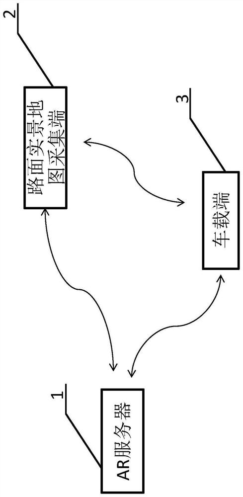
[0049] see figure 1 , the present invention provides a technical solution: a low-latency high-definition AR multi-channel navigation system, including an AR server, a vehicle terminal, and a real road map collection terminal;

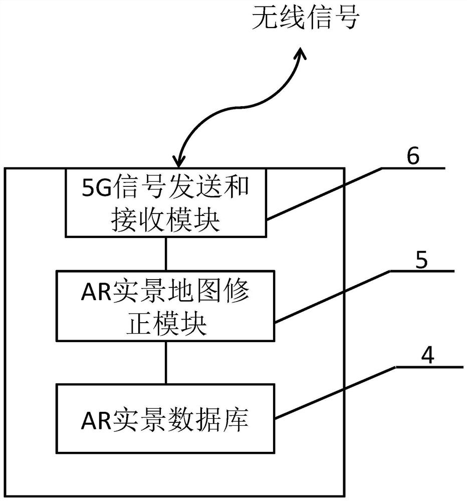
[0050] Among them, the AR server includes an AR real scene database, a 5G signal sending and receiving module and an AR real scene map correction module;

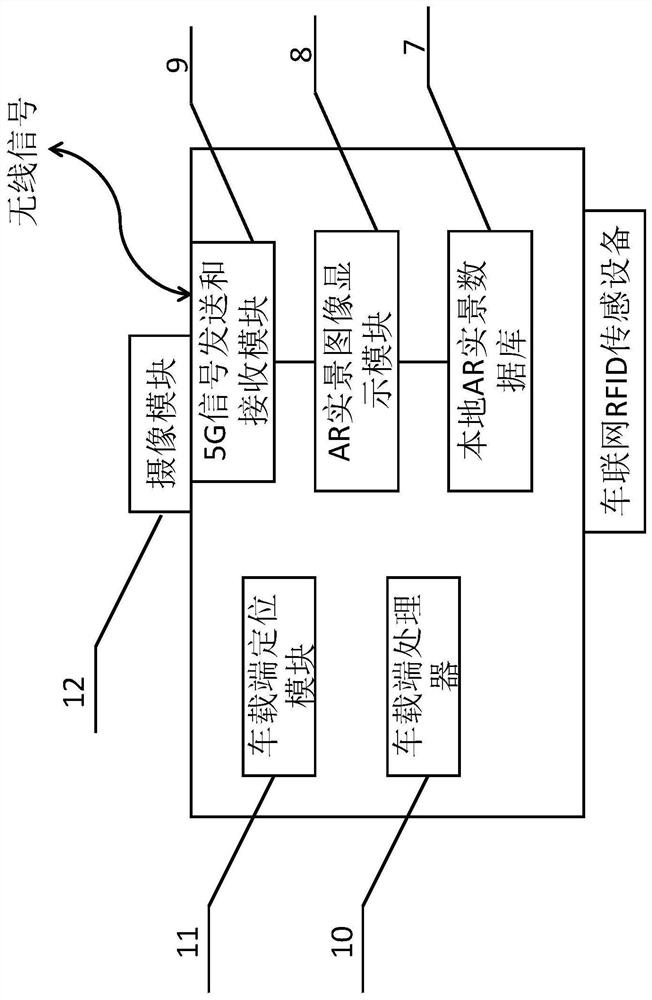
[0051] The vehicle terminal includes a local AR real-scene database, 5G signal...


PUM


Abstract

The invention discloses a low-latency high-definition AR multi-channel navigation system. The low-latency high-definition AR multi-channel navigation system includes an AR server, a vehicle-mounted terminal, and a road surface real-scene map collection terminal; wherein, the AR server includes an AR real-scene database and a 5G signal Sending and receiving module and AR real-scene map correction module; vehicle-mounted end includes local AR real-scene database, 5G signal sending and receiving module, camera module, AR real-scene image display module, vehicle-end processor, vehicle-side positioning module and car networking RFID sensor Equipment; the road surface real scene map acquisition terminal includes a road surface real scene map collection module, a carrier and a local AR real scene database, a vehicle-mounted positioning module and a carrier RFID sensing device, and the carrier is provided with a road surface real scene map collection module; in this application, it is proposed The navigation layer is divided into multiple layers, and only a small amount of data transmission is always required during navigation, thereby reducing construction costs and reducing the adverse effects of delay.

Description

technical field [0001] The invention relates to the technical field of AR navigation systems, in particular to a low-latency high-definition AR multi-channel navigation system. Background technique [0002] With the development of electronic technology, people began to live a faster and more convenient way of life. Nowadays, with the development of my country's economy, self-driving cars have become an increasingly indispensable part of people's lives. However, when we drive to a certain destination, due to the large and complex city or region, people cannot recognize the route, which brings inconvenience to life; however, with the development of navigation technology, the use of navigation systems for navigation Query the route to the destination, which brings convenience to people's life. [0003] In the prior art, the navigation system includes Baidu map, Gaode map and 360 map, etc. However, these navigation maps are displayed to the user in the form of a flat map, or t...

Claims


Application Information

Patent Timeline
Patent Type & Authority Patents(China)
IPC IPC(8): G01C21/36G06K9/00G06K9/34G06F16/2458G06F16/583G06F16/587G06T19/00
CPCG01C21/3647G01C21/365G01C21/3658G06F16/2468G06F16/583G06F16/587G06T19/006G06V20/20G06V10/267
Inventor 刘力刘铁堂龚利恒
Owner 深圳市掌锐电子有限公司
Why Eureka
Try Eureka