Method and device for constructing 'one graph' of territorial space planning and storage medium

A space planning and territorial technology, applied in 2D image generation, image data processing, structured data retrieval, etc., can solve problems such as low accuracy, and achieve the effect of improving accuracy

Pending Publication Date: 2020-12-15
GUANGZHOU URBAN PLANNING & DESIGN SURVEY RES INST
View PDF0 Cites 15 Cited by
  • Summary
  • Abstract
  • Description
  • Claims
  • Application Information

AI Technical Summary

Problems solved by technology

However, the inventor found in the process of implementing the present invention that the accuracy of the "one map" of national land space planning constructed in the prior art is low

Method used


Image

  • Method and device for constructing 'one graph' of territorial space planning and storage medium
  • Method and device for constructing 'one graph' of territorial space planning and storage medium
  • Method and device for constructing 'one graph' of territorial space planning and storage medium

Examples


Embodiment Construction

[0039] Next, the technical solutions in the embodiments of the present invention will be described in connection with the drawings of the embodiments of the present invention, and it is understood that the described embodiments are merely the embodiments of the present invention, not all of the embodiments. Based on the embodiments in the present invention, all other embodiments obtained without creative labor are not made in the premise of creative labor.

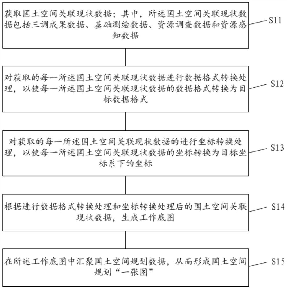
[0040] See figure 1 Constructs showing the method provided by the land space planning "a map" of the embodiment, the present invention is.

[0041] In an embodiment of the present invention, the land space planning to build "a map" method, comprising the steps of S11-S15:

[0042] S11, to obtain data associated with the status quo of land space; wherein the status of national spatial data consists of three related outcome data transfer, basic surveying and mapping data, resource data and resource-aware data.

[0043] It should...


PUM


Abstract

The invention relates to the technical field of territorial space planning, and discloses a method and device for constructing a territorial space planning 'one graph' and a storage medium. The methodcomprises the steps of obtaining territorial spatial association current situation data; wherein the territorial spatial association current situation data comprises three-way result data, basic surveying and mapping data, resource survey data and resource perception data; performing data format conversion processing on each territorial spatial association status data to convert the data format of each territorial spatial association status data into a target data format; coordinate conversion processing is performed on each territorial spatial association status data, so that the coordinatesof each territorial spatial association status data can be converted into coordinates under a target coordinate system; generating a working base map according to the processed territorial space association current situation data; and gathering territorial space planning data in the working base map so as to form a territorial space planning'one map '. According to the method, the accuracy of theconstructed territorial space planning 'one graph' is effectively improved.

Description

Technical field [0001] The present invention relates to the field of land space planning, and more particularly to a method of constructing a national spatial planning "a map", and a storage medium device. Background technique [0002] The landline planning is a guide to national space development, and the space blueprint for sustainable development is the basic basis for various development and protection construction activities. [0003] In the "Office of the Ministry of Natural Resources regarding the development of national spatial planning" a map "building notification and assessment of the current situation", it is proposed to carry out a comprehensive national spatial planning "a map" building space and land development and protection of the status quo and counties assessment specific tasks include: the formation of a unified base map, complete the construction of the national land information platform space, land space planning to build "a map" to carry out the assessment...

Claims


Application Information

Patent Timeline
Patent Type & Authority Applications(China)
IPC IPC(8): G06F16/25G06F16/29G06Q50/26G06T11/00
CPCG06Q50/26G06T11/00G06F16/258G06F16/29
Inventor 张鹏程林鸿何华贵黄慧明朱江王明省龚磊李少智
Owner GUANGZHOU URBAN PLANNING & DESIGN SURVEY RES INST
Why Eureka
Try Eureka