
Flood inundation range dynamic simulation method integrated with active and passive microwave remote sensing information

A submerged range and dynamic simulation technology, applied in the direction of design optimization/simulation, etc., can solve the problems that have not been reported in the literature, and it is difficult to meet the requirements of high space-time accuracy, so as to achieve strong operability and improve simulation accuracy and reliability.

Active Publication Date: 2020-12-15
CHANGJIANG RIVER SCI RES INST CHANGJIANG WATER RESOURCES COMMISSION
View PDF7 Cites 6 Cited by
  • Summary
  • Abstract
  • Description
  • Claims
  • Application Information

AI Technical Summary

Problems solved by technology

The inherent properties of remote sensing observations determine that using any one of them alone is difficult to meet the high temporal and spatial accuracy requirements of flood simulation, which is a bottleneck problem in existing scientific research and technical applications
The inventors of the present application found through research in China during the process of realizing the present invention that the fusion of active and passive microwave remote sensing information for dynamic simulation of flood range can be used as a breakthrough point to solve this bottleneck problem, and related technologies have not yet been reported in the literature

Method used


Image

  • Flood inundation range dynamic simulation method integrated with active and passive microwave remote sensing information
  • Flood inundation range dynamic simulation method integrated with active and passive microwave remote sensing information
  • Flood inundation range dynamic simulation method integrated with active and passive microwave remote sensing information

Examples


Embodiment Construction

[0047] In order to make the purpose, technical solutions and advantages of the embodiments of the present invention clearer, the technical solutions in the embodiments of the present invention will be clearly and completely described below in conjunction with the drawings in the embodiments of the present invention. Obviously, the described embodiments It is a part of embodiments of the present invention, but not all embodiments. Based on the embodiments of the present invention, all other embodiments obtained by persons of ordinary skill in the art without making creative efforts belong to the protection scope of the present invention.

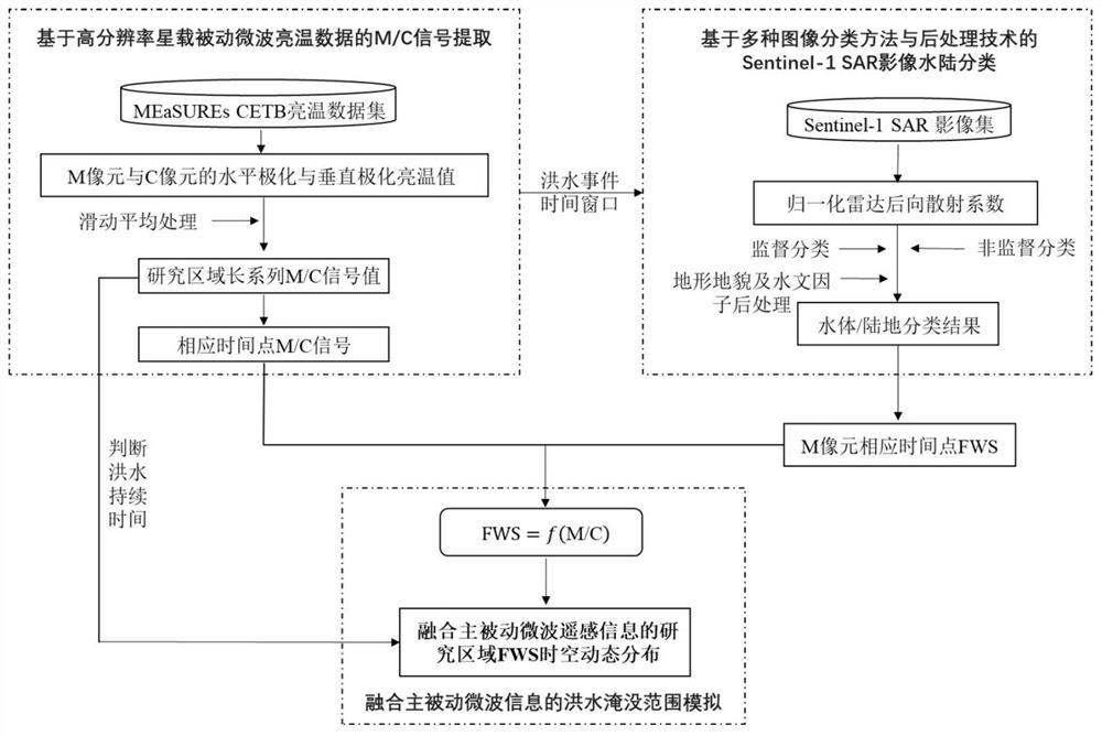
[0048] The embodiment of the present invention provides a dynamic simulation method of flood submersion range that integrates active and passive microwave remote sensing information. Firstly, the passive microwave brightness temperature data is used to obtain the long-term sequence of the M / C signal in the research area, and the threshold valu...


PUM


Abstract

A flood inundation range dynamic simulation method integrated with active and passive microwave remote sensing information comprises the steps of extracting a time sequence of M / C signals by satellite-borne passive microwave brightness temperature data, and preliminarily determining the occurrence time of a flood event; searching a satellite-borne active microwave remote sensing SAR image corresponding to the flood event based on the occurrence time of the flood event, and performing water body / land classification based on a machine learning method; based on the SAR image water body / land classification result, the surface water area ratio FWS of M pixels is extracted, making correlation analysis on the surface water area ratio FWS and corresponding M / C signals, and creating a relation model of M / C and FWS; utilizing the M / C signal to deduce the space-time distribution of the FWS at a permanent water body pixel, and realizing the dynamic simulation of the flood inundation range at the permanent water body. Based on real-time or quasi-real-time satellite microwave remote sensing observation information, the flood dynamic inundation range can be solved, flood simulation is practicallyguided, and important data support and decision basis are provided for flood emergency rescue and prevention.

Description

technical field [0001] The invention relates to the technical field of flood dynamic simulation, in particular to a method for dynamic simulation of flood submersion range by integrating active and passive microwave remote sensing information. Background technique [0002] Flood disaster prevention and control is an important field of national scientific research and development. The correct prevention and control of flood disasters is a major demand for national development and an important guarantee for the sustainable development of social economy and ecological environment. The dynamic simulation of flood submersion range can provide direct guidance for flood disaster prevention and control, and has great scientific research significance and practical application value. [0003] The dynamic simulation of flood submersion range has always been an important field of interdisciplinary research in hydrology, remote sensing, and disasters. Generally, in order to effectively...

Claims


Application Information

Patent Timeline
IPC IPC(8): G06F30/27
CPCG06F30/27Y02A10/40
Inventor 曾子悦林玉茹许继军王永强熊莹骆雪潘登
Owner CHANGJIANG RIVER SCI RES INST CHANGJIANG WATER RESOURCES COMMISSION
Learn More