
Outdoor scene rapid three-dimensional reconstruction device based on unmanned aerial vehicle image

A three-dimensional reconstruction and UAV technology, applied in the field of UAV technology and three-dimensional reconstruction, can solve the problems of high cost, inability to meet fast reconstruction, inability to achieve fast reconstruction or even real-time reconstruction, etc.

Active Publication Date: 2020-12-15
NAT INNOVATION INST OF DEFENSE TECH PLA ACAD OF MILITARY SCI
View PDF7 Cites 31 Cited by
  • Summary
  • Abstract
  • Description
  • Claims
  • Application Information

AI Technical Summary

Problems solved by technology

[0003] For the 3D reconstruction requirements of wild scenes, if it is realized based on the satellite platform, there is a problem of insufficient resolution, and it is impossible to clearly construct a 3D scene in the wild
For more accurate radar laser scanning reconstruction, it has the disadvantage of being expensive and heavy, and it is very inconvenient to perform 3D reconstruction in the field environment
Most of the traditional image-based 3D reconstruction methods have shortcomings such as long running time, poor timeliness, and high requirements for equipment, which cannot meet the needs of rapid reconstruction such as emergency rescue and disaster relief, military reconnaissance, and border security.
For fast and even real-time 3D reconstruction under this requirement, traditional methods cannot solve this problem well
Specifically, the traditional image-based 3D reconstruction methods have the following three problems: (1) This type of method has high requirements for the quality of the input image data, and the 3D reconstruction effect for large scenes in the wild is poor; (2) ) In the process of using drones for 3D reconstruction in this type of method, generally the drone is used to shoot all the scenes first, and then after returning, the captured images are processed to perform 3D reconstruction of the captured scenes, which does not have timeliness (3) The pictures taken by drones have high resolution and large amount of data. The traditional reconstruction method is very time-consuming and cannot meet the requirements of fast reconstruction or even real-time reconstruction.

Method used


Image

  • Outdoor scene rapid three-dimensional reconstruction device based on unmanned aerial vehicle image
  • Outdoor scene rapid three-dimensional reconstruction device based on unmanned aerial vehicle image
  • Outdoor scene rapid three-dimensional reconstruction device based on unmanned aerial vehicle image

Examples


Embodiment

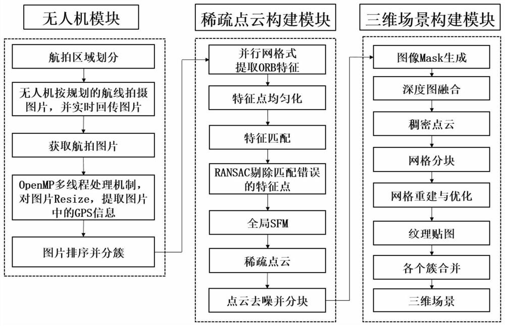
[0052] Embodiment: A device for fast three-dimensional reconstruction of outdoor scenes based on UAV images

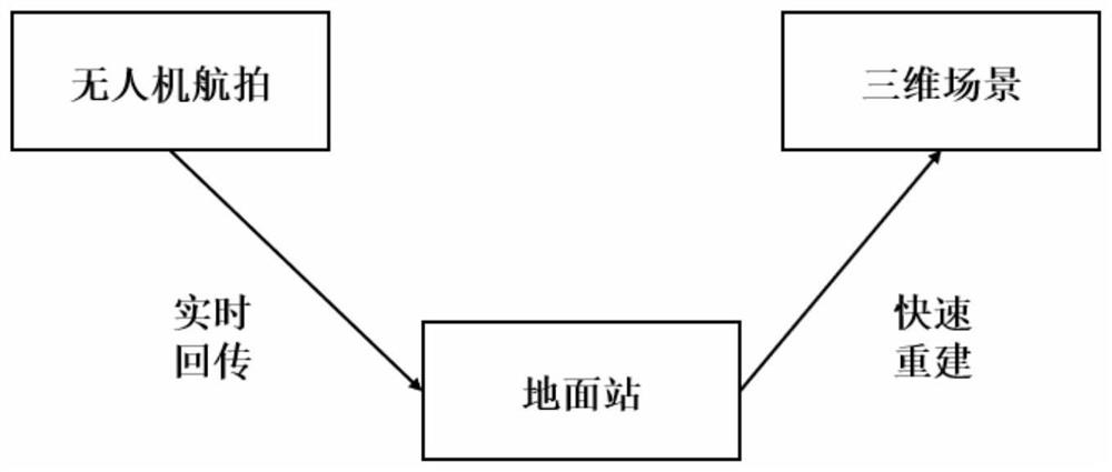
[0053] figure 1 The implementation flow chart of a fast 3D reconstruction device for outdoor scenes based on UAV images is given. This embodiment discloses a fast three-dimensional reconstruction device for outdoor scenes based on drone images, including a drone module, a sparse point cloud construction module and a three-dimensional scene construction module;

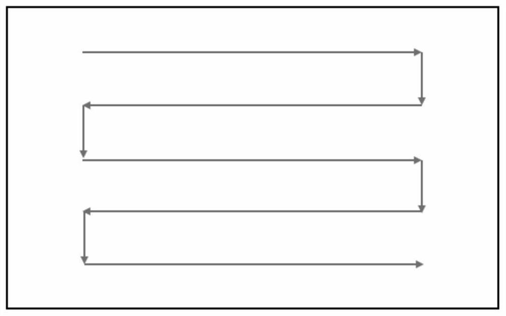
[0054] The unmanned aerial vehicle module includes an unmanned aerial vehicle and an unmanned aerial vehicle ground station. The unmanned aerial vehicle carries a camera and a communication device. Zigzag planning, the orthophoto taken by the UAV completely covers the scene to be shot, the camera carried by the UAV is used to shoot the monocular vision image sequence of the scene to be reconstructed, and the UAV communication device is used to real-time The captured pictures and RTK information are sent back ...


PUM


Abstract

The invention discloses an outdoor scene rapid three-dimensional reconstruction device based on an unmanned aerial vehicle image. The outdoor scene rapid three-dimensional reconstruction device comprises an unmanned aerial vehicle module, a sparse point cloud construction module and a three-dimensional scene construction module. The unmanned aerial vehicle module comprises an unmanned aerial vehicle and an unmanned aerial vehicle ground station. The unmanned aerial vehicle carries a camera and a communication device. The sparse point cloud construction module extracts feature points in each grid region through an OpenMP multi-thread processing mechanism, and performs feature matching on adjacent images; the three-dimensional scene construction module fuses the depth maps to obtain dense point clouds of the image clusters, and performs grid reconstruction based on a multi-view geometric algorithm, and combines reconstruction results of the clusters to obtain a three-dimensional structure of the whole scene. According to the device, parallel grid type feature extraction is realized, so that the reconstruction speed is greatly increased; through point cloud partitioning and grid partitioning, the memory pressure is reduced, and the reconstruction speed is increased.

Description

technical field [0001] The invention relates to the field of unmanned aerial vehicle technology and the field of three-dimensional reconstruction, in particular to a device for rapid three-dimensional reconstruction of outdoor scenes based on unmanned aerial vehicle images. Background technique [0002] At present, in outdoor or field applications, UAVs can realize rapid and comprehensive three-dimensional reconstruction of a scene, such as forestry resource protection in the wild, post-disaster rescue of fires and earthquakes, border security, oil fields or offshore platform oil and gas facilities, and power facilities. Monitoring and other fields have very important application value. [0003] For the 3D reconstruction requirements of wild scenes, if it is realized based on the satellite platform, there is a problem of insufficient resolution, and it is impossible to clearly construct a 3D scene in the wild. For more accurate radar laser scanning reconstruction, it has th...

Claims


Application Information

Patent Timeline
Patent Type & Authority Applications(China)
IPC IPC(8): G06T17/05G06T17/20G06T15/04G06T19/20
CPCG06T15/04G06T17/05G06T17/205G06T19/20
Inventor 邓宝松庞巧遇桂健钧唐荣富杨楚乐李靖尚天赐
Owner NAT INNOVATION INST OF DEFENSE TECH PLA ACAD OF MILITARY SCI
Learn More