Urban construction evaluation method based on deep learning and high-resolution satellite image

A satellite image, high-resolution technology, applied in the field of urban construction evaluation, which can solve the problems of inability to achieve urban construction evaluation, inaccurate evaluation of building outlines, changes in building area, and inability of models to apply to urban construction evaluation scenarios.

Active Publication Date: 2020-12-29
TONGJI UNIV
View PDF17 Cites 8 Cited by
  • Summary
  • Abstract
  • Description
  • Claims
  • Application Information

AI Technical Summary

Problems solved by technology

[0005] The first similar technology is "Deep Learning-Based High-Resolution Image Building Extraction Method and System" (patent application CN201910886542.6), which uses the RGB three-channel remote sensing image production of the building dataset released by SpaceNet to train specific types of buildings. The deep neural network model is used to extract building outlines. Since this method uses a single open dataset SpaceNet, the main content of its analysis will be based on the building datasets captured by WorldView satellites. Due to the different time and different satellite shooting results in terms of color difference, There will be some differences in inclination, image quality, etc., so the model trained by this single data set cannot be applied to more complex urban construction evaluation scenarios
[0006] The second similar technology is "A Method for Detec

Method used


Image

  • Urban construction evaluation method based on deep learning and high-resolution satellite image
  • Urban construction evaluation method based on deep learning and high-resolution satellite image

Examples


Embodiment Construction

[0017] In order to make the technical means, creative features, goals and effects of the present invention easy to understand, a method for urban construction evaluation based on deep learning and high-resolution satellite images of the present invention will be described in detail below in conjunction with the embodiments and accompanying drawings.

[0018]

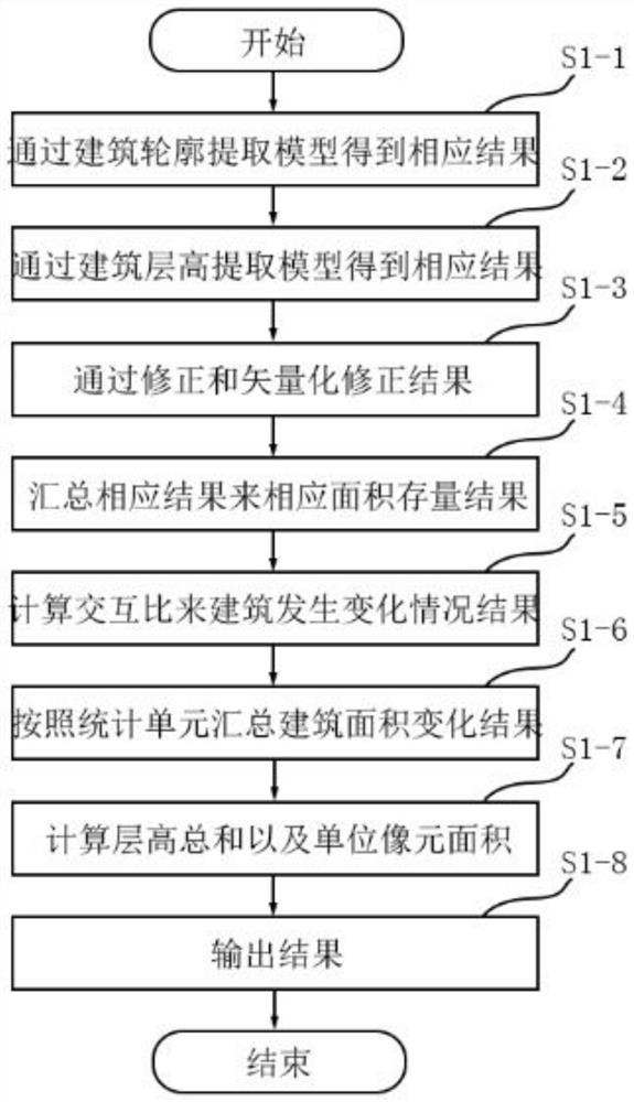
[0019] figure 1 It is a flowchart of an urban construction evaluation method based on deep learning and high-resolution satellite images in an embodiment of the present invention.

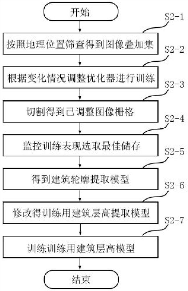
[0020] Such as figure 1 As shown, an urban construction evaluation method based on deep learning and high-resolution satellite images is used to extract the contours of buildings based on the input base year satellite image slices and at least one comparison year satellite image slices for analysis. The feature is that both the building outline extraction model and the building height extraction model include a data set production module, ...


PUM


Abstract

The invention provides an urban construction evaluation method based on deep learning and a high-resolution satellite image, which is used for extracting the contour of a building according to a baseyear satellite image slice map and at least one comparison year satellite image slice map so as to carry out analysis. The method comprises the following steps: processing the base year satellite image slice map and the comparison year satellite image slice map through a building contour extraction model and a building floor height extraction model to obtain a base year building floor height result and a comparison year building floor height result; and correcting the base year building contour result and the comparison year building contour result, so as to obtain the building area change summary analysis, the base year building area stock result and the comparison year building area stock result. The vector shape is simplified by vectorization, and the building vector boundary is corrected, so that the subsequent calculation of floor height sum is more accurate and closer to the reality; only the changed building area is calculated, so that the evaluation of the building contour areaand the total change condition of the building area is more detailed.

Description

technical field [0001] The invention relates to an urban construction evaluation method based on deep learning and high-resolution satellite images. Background technique [0002] As my country's urban development enters the era of "stock optimization", compared with the traditional field surveying and mapping method, there is a problem of inefficiency that is only applicable to censuses every few years. In order to achieve a large-scale, fast and accurate urban construction situation Tracking and monitoring, satellite remote sensing technology and deep learning technology provide new ideas. [0003] At present, urban construction evaluation based on high-resolution satellite images needs to implement two key technologies, one is to automatically extract building outlines from satellite images, and the other is to predict building heights based on satellite images. Combining these two parts of information, the buildings and construction area of ​​each urban unit can be counte...

Claims


Application Information

Patent Timeline
IPC IPC(8): G06K9/00G06K9/34G06K9/46G06K9/62G06F17/18
CPCG06F17/18G06V20/176G06V10/267G06V10/44G06F18/214Y02A30/60
Inventor 晏龙旭王德张尚武
Owner TONGJI UNIV
Why Eureka
Try Eureka