
Unmanned aerial vehicle route management system and method

A management system and UAV technology, applied in the field of UAV route management system, can solve problems such as insufficient UAV navigation data management, and achieve the effect of convenient operation and viewing and effective management.

Active Publication Date: 2021-01-05
郑州超图地理信息技术有限公司
View PDF8 Cites 1 Cited by
  • Summary
  • Abstract
  • Description
  • Claims
  • Application Information

AI Technical Summary

Problems solved by technology

[0003]Related technologies mainly use image capture or GPS positioning system to locate and manage the route of the UAV, but this method is not enough for the management of the navigation data of the UAV Perfect, for this reason, the present inventor provides a kind of UAV route management system and method

Method used


Image

  • Unmanned aerial vehicle route management system and method
  • Unmanned aerial vehicle route management system and method
  • Unmanned aerial vehicle route management system and method

Examples


Embodiment Construction

[0047] In order to make the purpose, technical solutions and advantages of this application clearer, the following in conjunction with the attached Figure 1-8 And embodiment, this application is described in further detail. It should be understood that the specific embodiments described here are only used to explain the present application, not to limit the present application.

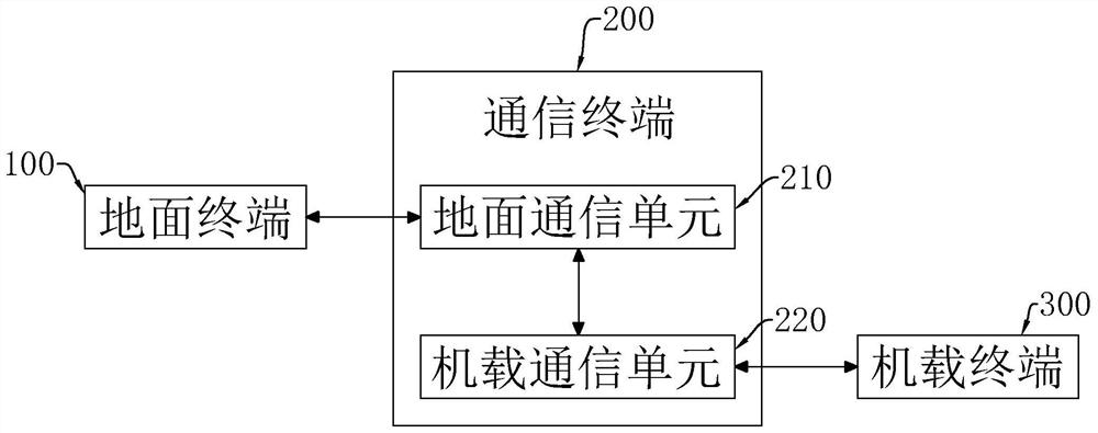
[0048] The embodiment of the present application discloses a drone route management system. refer to figure 1 The UAV route management system includes a ground terminal 100, a communication terminal 200, and an airborne terminal 300, and the ground terminal 100 realizes wireless communication with the airborne terminal 300 through the communication terminal 200, and then, the ground terminal 100 is used to control the airborne terminal 300; wherein, the communication terminal 200 includes a ground communication unit 210 and an airborne communication unit 220, the ground communication unit 210 is se...


PUM


Abstract

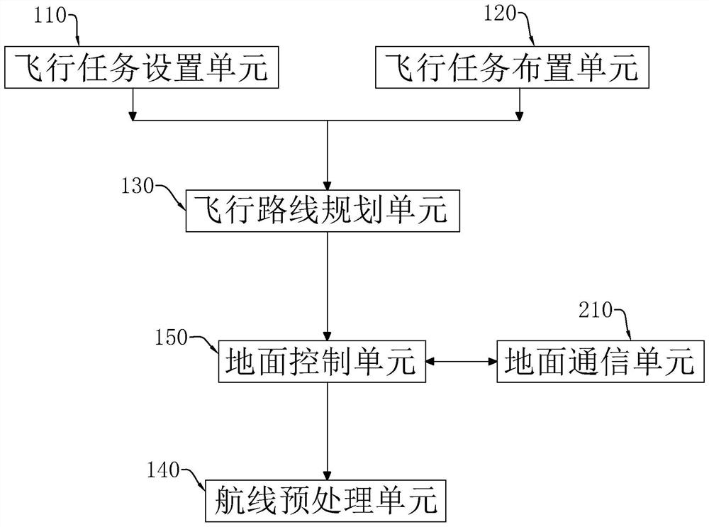
The invention relates to an unmanned aerial vehicle route management system, and the system comprises a ground terminal, a communication terminal and an airborne terminal; the ground terminal comprises a flight mission setting unit, a flight mission arrangement unit, a flight route planning unit, a route preprocessing unit and a ground control unit, wherein the flight mission setting unit is usedfor setting flight parameters; the flight mission arrangement unit is used for setting a flight mission area, the flight route planning unit is used for drawing a flight path according to flight parameters and the flight mission area, and the route preprocessing unit is used for processing data information collected by an unmanned aerial vehicle; the airborne terminal comprises an unmanned aerialvehicle flight control unit, an information acquisition unit and an unmanned aerial vehicle flight state monitoring unit, the unmanned aerial vehicle flight control unit is used for controlling the unmanned aerial vehicle to fly according to the flight path information, and the information acquisition unit is used for acquiring external information. The system has the effect of effectively managing the navigation data of the unmanned aerial vehicle.

Description

technical field [0001] The present application relates to the field of UAV navigation control management, in particular to a UAV route management system and method. Background technique [0002] Unmanned Aerial Vehicle (USV) is an unmanned aircraft operated by radio remote control equipment and its own program control device, which is suitable for replacing humans to complete specific tasks and tasks in dangerous, harsh and extreme environments. In the process of completing the mission, the UAV needs to plan how to effectively and safely complete its own mission process. In the mission planning process, the most important and complicated thing is to plan a flight route for the UAV to complete the mission, that is, UAV trajectory planning. [0003] Related technologies mainly use image capture or GPS positioning system to locate and manage the route of the UAV, but this method is not perfect for the management of the navigation data of the UAV. For this reason, the inventor ...

Claims


Application Information

Patent Timeline
IPC IPC(8): G05D1/10
CPCG05D1/101
Inventor 贾艳丽房河新贾艳红鲁小帅辛跃东房振伟栾春龙张梦雅杨志伟
Owner 郑州超图地理信息技术有限公司
Learn More