Lightweight semantic segmentation method for high-resolution remote sensing image

A remote sensing image and semantic segmentation technology, applied in the field of remote sensing image processing, can solve the problems of low operation efficiency of segmentation algorithms and shorten the time for semantic segmentation of remote sensing images, so as to improve the accuracy of semantic segmentation, reduce the amount of parameters and calculations, and improve the operation. effect of speed

A remote sensing image and semantic segmentation technology, applied in the field of remote sensing image processing, can solve the problems of low operation efficiency of segmentation algorithms and shorten the time for semantic segmentation of remote sensing images, so as to improve the accuracy of semantic segmentation, reduce the amount of parameters and calculations, and improve the operation. effect of speed

CN112183360AActive Publication Date: 2021-01-05SHANGHAI JIAO TONG UNIV

Image

  • Lightweight semantic segmentation method for high-resolution remote sensing image
  • Lightweight semantic segmentation method for high-resolution remote sensing image
  • Lightweight semantic segmentation method for high-resolution remote sensing image

Examples


Embodiment Construction

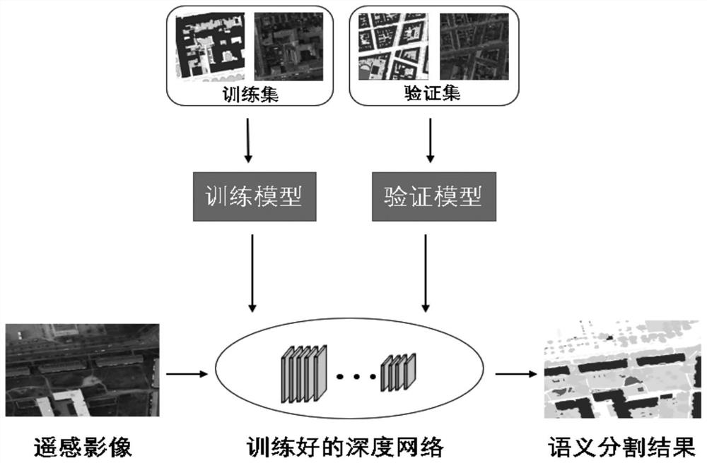
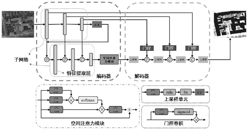
[0034] like figure 1 As shown, it is a lightweight semantic segmentation method based on high-resolution remote sensing images involved in the present invention, including the following steps:

[0035] Step A. Divide the remote sensing image sample data set into training set, verification set and test set according to the ratio of 0.5:0.15:0.35, and then make a label file for each sub-data set. The label file corresponds to the image file one by one, and stores them separately In the file directory corresponding to the hard disk, set the directory path of the read-in data before training the model, set the number of categories of the network output layer to the number of categories of the included ground objects according to the number of categories that the data set needs to classify, and set the learning rate is 0.0001, the number of iterations is 1500, the exponential decay rate is (0.9, 0.99), the regularization coefficient is 0.0002, and the loss function is the cross-ent...


PUM


Abstract

A lightweight semantic segmentation method for a high-resolution remote sensing image comprises the steps of network construction, training and testing. Specifically, a deep semantic segmentation network of an encoder-decoder structure is constructed for a pytorch deep learning framework, after network training is carried out based on a remote sensing image data sample set, a to-be-tested remote sensing image serves as network input. A segmentation result of the remote sensing image is obtained. According to the method, on one hand, model parameters are reduced by decomposing depth separable convolution, the calculation complexity is reduced, the semantic segmentation time of the high-resolution remote sensing image is shortened, and the semantic segmentation efficiency of the high-resolution remote sensing image is improved; and on the other hand, semantic segmentation precision is improved through multi-scale feature aggregation, a spatial attention module and gating convolution, sothat the proposed lightweight deep semantic segmentation network can accurately and efficiently realize semantic segmentation of a high-resolution remote sensing image.

Description

Technical field [0001] The invention relates to a technology in the field of remote sensing image processing, specifically a lightweight semantic segmentation method for high-resolution remote sensing images. Background technique [0002] With the development of aerospace technology, high-resolution remote sensing images are increasingly easy to obtain in large quantities. The use of image segmentation to extract the boundaries of ground objects in remote sensing images is the basis for further analysis and utilization of high-resolution remote sensing images. Traditional high-resolution remote sensing image segmentation algorithms usually rely on artificially designed features such as texture and color to extract the boundaries of objects in the image. However, they can only obtain the boundaries of the objects themselves and cannot simultaneously obtain the semantics of the areas defined by the boundaries. Information, that is, the category of features. In recent years, s...

Claims


Application Information

Patent Timeline
05 Jan 2021
Publication
CN112183360A
IPC
G06K9/00; G06K9/34; G06K9/46; G06K9/62
CPC
G06V20/13; G06V10/26; G06V10/40; G06F18/253; G06F18/214
Inventors
霍宏; 吕亮