Vegetation classification method of remote sensing image based on gradient scale interval change regular operator

A technology of remote sensing images and changing rules, applied in the field of remote sensing images, can solve problems such as difficulties, failure to find better parameters, difficulty in obtaining classification results, etc., and achieve the effect of improving accuracy

Active Publication Date: 2022-07-19
CHANGCHUN INST OF TECH
View PDF14 Cites 0 Cited by
  • Summary
  • Abstract
  • Description
  • Claims
  • Application Information

AI Technical Summary

Problems solved by technology

[0003] Currently, there are two main methods used for automatic remote sensing image vegetation classification: the first is the traditional shallow intelligent classification method, which uses auxiliary texture algorithms (such as gray-level co-occurrence matrix) to obtain the texture of vegetation in remote sensing images. features, and then use shallow classification models (such as neural networks, support vector machines, and decision trees) to classify images; such methods have low computational complexity and are easy to implement, but a key problem with this method is that The shooting of remote sensing images will be affected by terrain, sensors, vegetation distribution direction, and light direction. Each texture algorithm needs to conduct a large number of experiments on scale and direction parameters; and there may also be textures displayed by different ground objects in the same image. Inconsistent scales make it impossible to find better parameters, so it is difficult for this type of method to obtain good classification results
The second category is the deep learning method, which introduces the convolutional neural network architecture to classify vegetation. This type of method can obtain better classification results, but on the one hand, the series of deep learning methods require a large number of sample supports, and the vegetation area itself is small in many areas. It is difficult to support a large sample size, and the deep learning algorithm cannot play a role when there are few samples; on the other hand, the convolution is also affected by the input scale. If there are inconsistent texture scales displayed by different ground objects in the same image, the same The choice of convolution scale for deep learning neural network will also encounter difficulties

Method used


Image

  • Vegetation classification method of remote sensing image based on gradient scale interval change regular operator
  • Vegetation classification method of remote sensing image based on gradient scale interval change regular operator
  • Vegetation classification method of remote sensing image based on gradient scale interval change regular operator

Examples


Embodiment 1

[0088] A method for classifying vegetation in remote sensing images based on a gradient scale interval change rule operator according to the present invention includes the following steps:

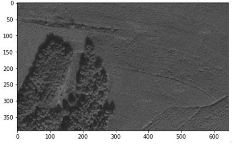
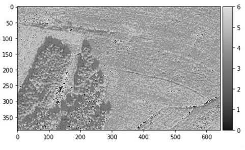
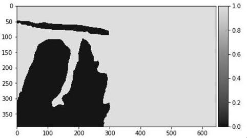
[0089] S1, input the multi-band remote sensing image Image, obtain the width Width of the image, obtain the height of the image, obtain the segmented image brightness variable SingleImage, obtain the brightness discrimination variable Qufen, and obtain the brightness discrimination tolerance variable Quefenrong;

[0090] S101, input a multi-band remote sensing image Image;

[0091] S102, obtain the width of the image Width= the width of the Image; obtain the height of the image Height= the height of the Image; obtain the number of bands of the image Bands= the number of bands of the Image;

[0092] S103, create a segmented image brightness variable SingleImage=create a two-dimensional array whose width is Width and height is Height, and the value of all elements of the array is 0;

[0093...

Embodiment 2

[0161]S1, input the multi-band remote sensing image Image, obtain the width Width of the image, obtain the height of the image, obtain the segmented image brightness variable SingleImage, obtain the brightness discrimination variable Qufen, and obtain the brightness discrimination tolerance variable Quefenrong;

[0162] S101, input a multi-band remote sensing image Image;

[0163] S102, obtain the width of the image Width= the width of the Image; obtain the height of the image Height= the height of the Image; obtain the number of bands of the image Bands= the number of bands of the Image;

[0164] S103, create a segmented image brightness variable SingleImage=create a two-dimensional array whose width is Width and height is Height, and the value of all elements of the array is 0;

[0165] S104, the initial stage counter InitCounter=1;

[0166] S105, temporarily store the single-band image variable TempImage=read the content of the InitCounter band of Image;

[0167] S106, te...


PUM


Abstract

The invention discloses a remote sensing image vegetation classification method based on a gradient scale interval change rule operator, and establishes a gradient scale interval change rule operator, which can describe different brightness intervals from non-directional specific brightness intervals and various scales. The characteristics of vegetation reflected in remote sensing images, and then use a support vector machine model to learn these characteristics to obtain a classification model, and use the gradient scale interval change regular operator and classification model to obtain the classification results of remote sensing images. Using the patent of the present invention can avoid the influence of specific scale and specific direction on classification, and show the characteristics of vegetation on remote sensing images from the interval characteristics and scale change characteristics of specific brightness pixels of vegetation on the image, and then use these characteristics. Improved accuracy of vegetation classification in remote sensing images.

Description

Technical field: [0001] The invention discloses a remote sensing image vegetation classification method based on a gradient scale interval change regular operator, and belongs to the technical field of remote sensing images. Background technique: [0002] Through remote sensing images, vegetation distribution data in a large area can be obtained. These distributions can well reflect agricultural production, environment and vegetation protection, the number of specific plant populations, and vegetation succession in specific areas. These conditions are formulated Therefore, it is of great value to obtain the vegetation types of a specific surface range through remote sensing images. Automatic identification of vegetation types in remote sensing images is the most important way to obtain these data quickly. [0003] At present, the main methods used for automatic remote sensing image vegetation classification include two categories: the first type is the traditional shallow i...

Claims


Application Information

Patent Timeline
Patent Type & Authority Patents(China)
IPC IPC(8): G06V10/774G06V10/764G06V20/10G06V10/143G06K9/62G06T7/45
CPCG06T7/45G06T2207/10032G06V20/188G06V10/143G06F18/2411G06F18/214
Inventor 潘欣赵健许骏佘向飞付浩海张华
Owner CHANGCHUN INST OF TECH
Why Eureka
Try Eureka