Supercharge Your Innovation With Domain-Expert AI Agents!

Mountain disaster early warning and monitoring device based on machine vision and early warning and monitoring method

A kind of early warning monitoring and mountain technology, applied in the direction of measuring devices, optical devices, color TV parts, etc., can solve the problems of monitoring work termination, total station can not observe the target, displacement measurement distortion, etc., to achieve convenient installation of the device Effect

Pending Publication Date: 2021-01-29
上海同禾工程科技股份有限公司
View PDF6 Cites 9 Cited by
  • Summary
  • Abstract
  • Description
  • Claims
  • Application Information

AI Technical Summary

Problems solved by technology

[0004] The limitation of satellite navigation is that its signal continuity is insufficient. GNSS signals are vulnerable to accidental or deliberate interference, such as terrain and leaf occlusion, which weaken or reflect signals, distorting displacement measurement; the total station has a long visual range and can observe far However, it needs to be installed in a fixed area. There is a lot of rain and fog in the mountains. Once it rains and fogs, the total station cannot observe the target. However, the rain and fog weather is the time when the risk of landslides is the greatest.
The crack meter is installed on the surface of the mountain, affected by the rain and fog environment in the mountain, the accuracy of the sensor is difficult to guarantee, and the instrument will also be damaged by wild animals, resulting in the termination of the monitoring work
[0005] The above-mentioned traditional monitoring methods often fail to achieve the ideal monitoring effect. It is necessary to provide an early warning monitoring device and early warning monitoring method for mountain disasters, which can continuously and accurately monitor landslides automatically and in real time, so as to ensure timely early warning of mountain safety and protect surrounding residents. and the personal and property safety of staff

Method used


Image

  • Mountain disaster early warning and monitoring device based on machine vision and early warning and monitoring method

Examples


Embodiment Construction

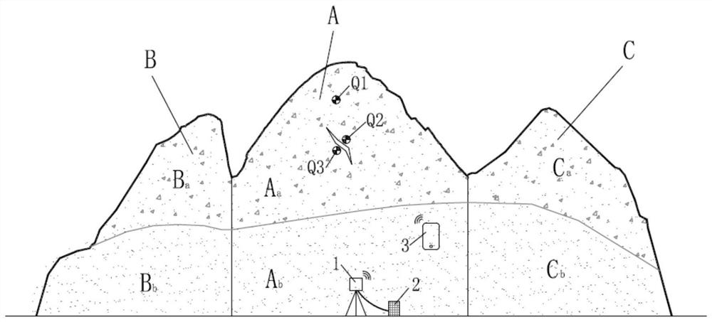
[0029] Landslides are characterized by strong suddenness, wide distribution and great destructiveness, which cause huge economic losses and casualties every year. In order to predict the risk of landslides in advance, GNSS global satellite navigation system and crack meter are deployed on the mountain, the displacement of the mountain surface is monitored through GNSS, and the development of cracks on the mountain surface is monitored through the crack meter. Due to the lack of signal continuity of the GNSS global satellite navigation system, the GNSS signal is vulnerable to accidental or deliberate interference, such as terrain and leaf occlusion, which weakens or reflects the signal, distorting the displacement measurement; the crack meter is installed on the surface of the mountain, affected by the rain and fog environment in the mountain The accuracy of the sensor is difficult to guarantee, and the instrument will also be damaged by wild animals, resulting in the terminatio...


PUM


Abstract

The invention discloses a mountain disaster early warning and monitoring device based on machine vision, which comprises an intelligent camera, an electric control system, control equipment and feature targets, wherein the feature targets are arranged in a most dangerous region of a landslide and on two sides of cracks appearing on a mountain; the intelligent camera is installed in a mountain sliding region and can observe the feature targets installed in a region to be monitored, an embedded software algorithm is built in the intelligent camera, image information at the installation positionsof the feature targets used for monitoring landslide and mountain cracks can be collected in real time, and the position information of the feature targets can be monitored and resolved and analyzed;the electric control system is installed on the periphery of the intelligent camera, is connected with the intelligent camera, and is used for supplying power to the intelligent camera and transmitting the image information, position information and resolving analysis results collected by the intelligent camera to the cloud end in a network mode to be consulted by remote control equipment connected with the network; and the remote control equipment performs information interaction with the electric control system through a network.

Description

technical field [0001] The invention relates to the technical field of early warning and monitoring of mountain disasters, in particular to a machine vision-based early warning and monitoring device for mountain disasters and an early warning and monitoring method. Background technique [0002] As the main type of geological disasters, landslides have the characteristics of strong suddenness, wide distribution and great destructiveness, which cause huge economic losses and casualties every year, and are serious constraints to the national economic construction and social development of our country. [0003] At present, the more common landslide monitoring and early warning technology is to deploy GNSS global satellite navigation system and crack meter on the mountain, which can monitor the displacement of the mountain surface through GNSS, and also measure the sliding displacement through the total station; monitor the cracks on the mountain surface through the crack meter d...

Claims


Application Information

Patent Timeline
Patent Type & Authority Applications(China)
IPC IPC(8): G01B11/02G01B11/16G01C15/02G08B21/10H04N5/232H04L29/08
CPCG01B11/022G01B11/16G01C15/02G08B21/10H04L67/10H04N23/60
Inventor 宋爽徐辉姚鸿梁
Owner 上海同禾工程科技股份有限公司
Features
  • R&D
  • Intellectual Property
  • Life Sciences
  • Materials
  • Tech Scout
  • Unparalleled Data Quality
  • Higher Quality Content
  • 60% Fewer Hallucinations
Learn More