Highway unmanned aerial vehicle emergency simulation method under traffic accident

A technology for highways and traffic accidents, applied in traffic control systems, design optimization/simulation, traffic control systems for road vehicles, etc., can solve the problem of no data visualization, no road network operation status reflection, and no dispatch plan emergency strategy plan Analyze and evaluate issues to achieve clear and intuitive data analysis, improve road traffic capacity, and achieve better information acquisition effects

Active Publication Date: 2021-03-02
BEIHANG UNIV
View PDF10 Cites 8 Cited by
  • Summary
  • Abstract
  • Description
  • Claims
  • Application Information

AI Technical Summary

Problems solved by technology

[0003] Most of the existing domestic patents are only for the research on the visual simulation of UAV flight in the simulated flight environment, and have not yet involved the interaction between UAV and ground information to realize traffic simulation
A single UAV flight visual simulation can only perceive the surrounding environment, and cannot specifically reflect the operating status of the entire road network. Attitude and other processing, has not yet involved the acquisition of ground traffic data, such as average speed, road section traffic volume, vehicle driving route, etc., and there is no visual representation of the data in the storage and output of the data, so the existing UAV flight The simulation system cannot analyze and evaluate the dispatching plan of multiple UAVs under traffic accidents and the corresponding emergency strategy plan

Method used


Image

  • Highway unmanned aerial vehicle emergency simulation method under traffic accident
  • Highway unmanned aerial vehicle emergency simulation method under traffic accident
  • Highway unmanned aerial vehicle emergency simulation method under traffic accident

Examples


Embodiment Construction

[0032] The present invention will be further described in detail with reference to the accompanying drawings and embodiments.

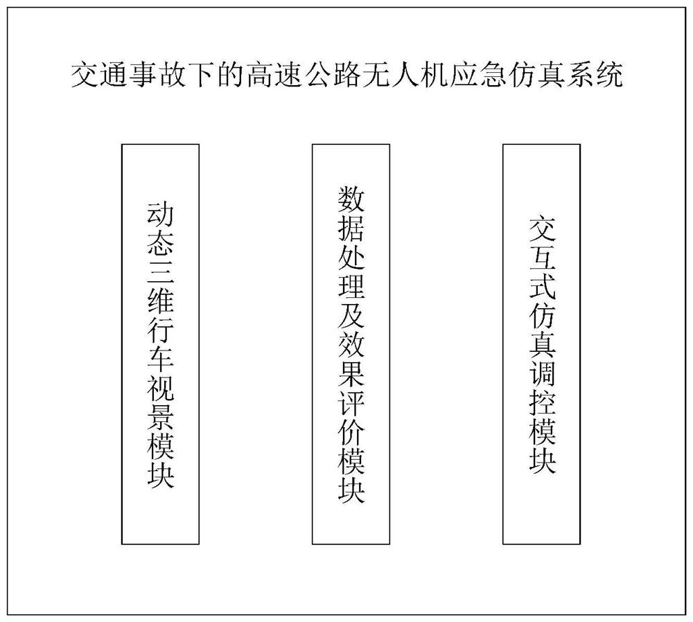
[0033] see figure 1 As shown, the highway UAV emergency simulation system under traffic accidents includes a dynamic three-dimensional driving vision module, an interactive simulation control module, a data processing and effect evaluation module. The interactive simulation control module transmits the accident location information to the dynamic 3D driving vision module to generate a highway simulation environment under traffic accidents, and at the same time issues UAV scheduling instructions to control UAV flight and run road network traffic flow simulation.

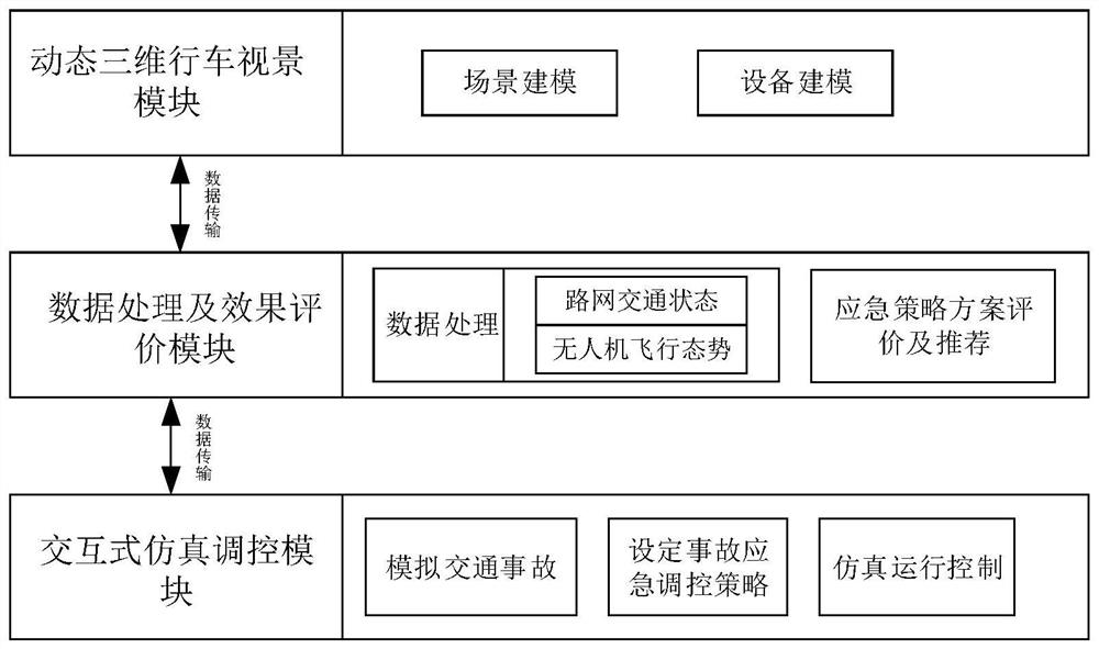
[0034] see figure 2As shown, the data processing and effect evaluation module of the simulation system includes two modules: data receiving, processing, analysis, storage and effect evaluation. Situation data is received and organized. During the simulation process, the UAV airborne sensor...


PUM


Abstract

The invention discloses a highway unmanned aerial vehicle emergency simulation method under a traffic accident. The highway unmanned aerial vehicle emergency simulation method under the traffic accident is realized by adopting a highway unmanned aerial vehicle emergency simulation system under the traffic accident. The method comprises the steps that 1, a dynamic three-dimensional driving scene module preliminarily creates a terrain model through returned accident site coordinate information; and 2, an interactive simulation regulation and control module deploys an unmanned aerial vehicle scheduling scheme according to the distance between a parking apron and an accident site, the state of an unmanned aerial vehicle and the like in combination with an unmanned aerial vehicle scheduling algorithm, simulation parameters are set, and simulation is conducted; automatic takeoff, cruise monitoring and return functions of the unmanned aerial vehicle are realized; according to the invention, aplurality of unmanned aerial vehicles can be dispatched to carry out cooperative investigation according to traffic accident conditions, a good information acquisition effect is achieved, and trafficaccident handling conditions can be effectively simulated.

Description

technical field [0001] The invention relates to the technical field of unmanned aerial vehicles, in particular to an emergency simulation system for expressway unmanned aerial vehicles under traffic accidents. The aim is to mobilize unmanned aerial vehicles to continuously monitor the accident site by simulating a traffic accident on the expressway, so as to obtain road network traffic data, and simulate and evaluate the traffic road network safety situation and emergency control strategy. Background technique [0002] At present, my country's highway mileage ranks first in the world, but there are still problems such as high traffic accident rate and insufficient emergency rescue level, and the death rate of traffic accidents remains high. Due to the imperfection of my country's expressway traffic information collection equipment, it is difficult to obtain complete real-time dynamic road network traffic data, and at the same time, there is a lack of information transmission...

Claims


Application Information

Patent Timeline
IPC IPC(8): G08G1/00G06F30/18G06F30/25G06T17/05G06F111/02
CPCG08G1/00
Inventor 于海洋焦港欣任毅龙王飞杨阳
Owner BEIHANG UNIV
Why Eureka
Try Eureka