Real-time positioning method and device based on on-board control point library and storage medium
A technology of real-time positioning and control points, applied in geographic information databases, image data processing, special data processing applications, etc., can solve the problems of complex remote sensing application mode processing process, restrictions on the efficient and fast application of remote sensing data, and many links involved. Achieve the effect of solving the limited resources on the star, reducing the amount of data, and improving the processing speed
- Summary
- Abstract
- Description
- Claims
- Application Information
AI Technical Summary
Problems solved by technology
Method used
Image


Examples
Embodiment 1
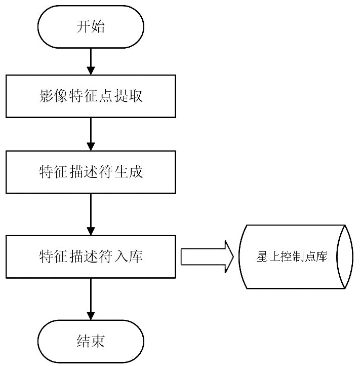
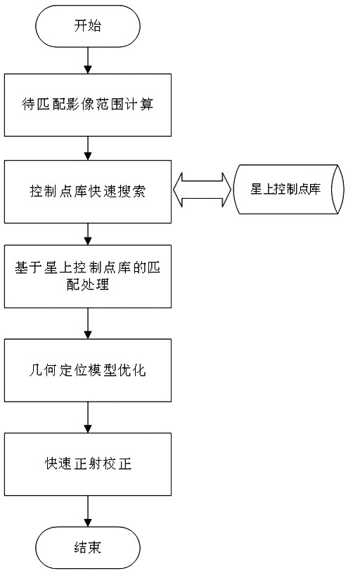
[0044] The real-time positioning method based on the on-board control point library described in this embodiment includes reading the reference image data and extracting image feature points; processing the extracted feature point information and high-precision position information of feature points into control points; According to the range of longitude and latitude, it is stored in the database, and the control point database table of different regions is formed to form a control point library; according to the latitude and longitude range of the image to be matched, the control point data of the corresponding area is searched in the control point library, and then the control point is transferred using the matching algorithm. Stab on the image to be matched; optimize the geometric positioning model and image positioning based on the control point data after piercing.
[0045] Among them, such as figure 1 As shown, the construction process of the control point library speci...
Embodiment 2
[0072] On the basis of Embodiment 1, in another embodiment of the present disclosure, the on-orbit real-time high-precision positioning processing method based on the on-board control point library includes:
[0073] Image four-corner point coordinate calculation and initial RPC fitting: The image four-corner point coordinate calculation is mainly based on auxiliary data such as attitude, track, and travel time internal and external orientation elements, which are calculated using a single-chip positioning model, and then the input image is gridded according to a certain grid spacing , and then use the single-chip positioning model to calculate the coordinate information of each grid point, and finally fit the initial RPC parameters. The entire algorithm flow is as follows Figure 5 shown.
[0074] Such as Figure 6 Shown is an input image; Figure 7 It is the execution result of the algorithm for calculating the coordinates of the four corners of the image and fitting the i...
Embodiment 3
[0140] On the basis of Embodiment 2, in another specific embodiment of the present disclosure, image orthorectification processing is implemented by using an MPI-based multi-task distribution parallel processing mechanism.
[0141] The main steps of image orthorectification are as follows:
[0142] ① Calculation of output image range
[0143] Calculate the latitude and longitude coordinates of the four corner points of the output image according to the pixel coordinates (row and column numbers) of the four corner points of the input image and the refined RPC parameter information, and judge the maximum and minimum values of the longitude and latitude of the output image in the longitude direction and latitude direction to obtain MaxLon, MinLon, MaxLat, MinLat, such as Figure 9 According to the specified resolution PixelSpacing, the length and width range of the output image can be calculated.
[0144] DstImgWidth=(MaxLon-MinLon) / PixelSpacing;
[0145] DstImgHeight=(MaxLa...
PUM
 Abstract
Description
Claims
Application Information
 - R&D
- Intellectual Property
- Life Sciences
- Materials
- Tech Scout
- Unparalleled Data Quality
- Higher Quality Content
- 60% Fewer Hallucinations
Browse by: Latest US Patents, China's latest patents, Technical Efficacy Thesaurus, Application Domain, Technology Topic, Popular Technical Reports.
© 2025 PatSnap. All rights reserved.Legal|Privacy policy|Modern Slavery Act Transparency Statement|Sitemap|About US| Contact US: help@patsnap.com