SLAM positioning and navigation method and system based on multi-sensor fusion

A multi-sensor fusion, positioning and navigation technology, applied in navigation calculation tools, radio wave measurement systems, instruments, etc., can solve the problems of low detection accuracy of obstacle boundaries, decreased real-time performance, and low accuracy of pose and attitude.

Pending Publication Date: 2021-03-19
BEIJING TECHNOLOGY AND BUSINESS UNIVERSITY
View PDF0 Cites 27 Cited by
  • Summary
  • Abstract
  • Description
  • Claims
  • Application Information

AI Technical Summary

Problems solved by technology

Elastic Fusion uses the Iterative Closest Point (ICP) algorithm to reconstruct the map based on surface elements online with the support of GPU, which can process RGB-D camera frames in real time in a small environment, but the processing time of each frame will vary with the map The num

Method used


Image

  • SLAM positioning and navigation method and system based on multi-sensor fusion
  • SLAM positioning and navigation method and system based on multi-sensor fusion
  • SLAM positioning and navigation method and system based on multi-sensor fusion

Examples


Embodiment Construction

[0043] In order to make the purpose, technical solutions and advantages of the embodiments of the present invention clearer, the technical solutions in the embodiments of the present invention will be clearly and completely described below in conjunction with the drawings in the embodiments of the present invention. Obviously, the described embodiments It is a part of embodiments of the present invention, but not all embodiments. Based on the embodiments of the present invention, all other embodiments obtained by persons of ordinary skill in the art without making creative efforts belong to the protection scope of the present invention.

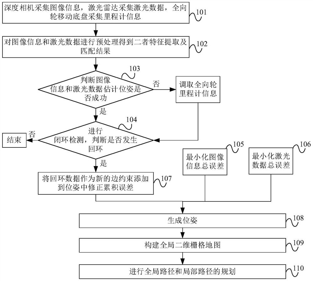
[0044] A SLAM positioning and navigation method based on multi-sensor fusion, the specific implementation steps are as follows figure 1 shown, including:

[0045] Step 101, the depth camera collects image information, the laser radar collects laser data, and the omnidirectional wheel mobile chassis collects odometer information.

[0046] St...


PUM


Abstract

The technical scheme of the invention provides an SLAM positioning and navigation method and system based on multi-sensor fusion. According to the invention, in combination with the information of a depth camera, a laser radar and an omnidirectional wheel odometer, an obstacle point cloud, a two-dimensional grid map and a dense point cloud are output for navigation; and by improving a fusion method of a Bayesian data algorithm, a navigation algorithm based on A* and DWA and an exception handling method are designed, and real-time performance is achieved. According to the invention, the Bayesian method is improved, the information of the depth camera, the laser radar and the omnidirectional wheel odometer is fused, and the purposes of multi-sensor assisted automatic positioning, global two-dimensional grid map construction and autonomous navigation of the mobile robot with the obstacle avoidance capacity are achieved.

Description

technical field [0001] The invention relates to the field of robot autonomous navigation, in particular to a SLAM positioning and navigation method and system based on multi-sensor fusion. Background technique [0002] At present, in the field of mobile robots, autonomous navigation of mobile robots is gradually becoming a research hotspot in order to work in an environment beyond the reach of humans, provide convenience for people's daily life, and liberate humans from trivial matters. To realize the autonomous operation of mobile robots, three problems need to be solved: "where is it at the moment", "what is the surrounding environment at the moment", and "how to reach the destination", respectively corresponding to: positioning, map construction, and navigation. The robot needs to collect sensor data carried by itself , determine the trajectory, and construct the environment map at the same time. Therefore, it is very meaningful to establish a cheap, effective and accura...

Claims


Application Information

Patent Timeline
IPC IPC(8): G01C21/20G01C11/02G01S17/89G01S17/93
CPCG01C21/20G01C11/02G01S17/89G01S17/93
Inventor 吴叶兰谢宇欣刘杰管慧宁廉小亲
Owner BEIJING TECHNOLOGY AND BUSINESS UNIVERSITY
Why Eureka
Try Eureka