Rural road boundary line automatic extraction method based on aerial photography images

An automatic extraction and boundary line technology, applied in the fields of instruments, character and pattern recognition, computer components, etc., can solve the problems of poor algorithm stability, slow deep learning training time, and poor road extraction effect.

Active Publication Date: 2021-05-14
SPEED SPACE TIME INFORMATION TECH CO LTD
View PDF16 Cites 4 Cited by
  • Summary
  • Abstract
  • Description
  • Claims
  • Application Information

AI Technical Summary

Problems solved by technology

[0005] Traditional road extraction algorithms, including template matching algorithms, knowledge-driven road extraction methods, object-oriented road extraction methods, etc., have poor road extraction results when road interference is serious
In addition, the above-mentioned algorithms are all based on the analysis of the overall characteristics of the road in the entire image for road extraction, which has a large amount of calculation and low efficiency. In addition, in the image, the characteristics of rural roads change greatly, and there is a large difference between the characteristics of some roads and the whole. section, the stability of the algorithm is poor
Although the deep learning method has the advantages of strong generalization and high degree of automation, it also has some problems: on the one hand, it requires a large number of similar sample data sets, on the other hand, the training time of deep learning is too slow, and the current model method is still in the experimental stage. In the laboratory research stage, large-scale and large-scale road extraction based on deep learning has not yet been carried out

Method used


Image

  • Rural road boundary line automatic extraction method based on aerial photography images
  • Rural road boundary line automatic extraction method based on aerial photography images
  • Rural road boundary line automatic extraction method based on aerial photography images

Examples


Embodiment

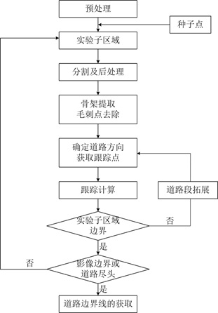
[0068] Example: such as figure 1 As shown, the automatic extraction method of the rural road boundary line based on aerial photography includes the following steps:

[0069] S1 Acquiring data: Obtaining aerial images of the area to be studied;

[0070] S2 obtains the sub-region: input the seed point, obtains the experimental sub-region; the step S2 specifically includes the following steps:

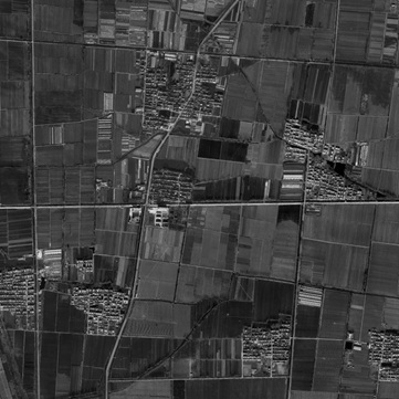
[0071] S21 preprocessing: cutting and splicing the original aerial images to obtain the original images; using ArcGIS software to splice and cut them to obtain images with a resolution of 0.2 meters and a size of 12000*12000 pixels; in order to verify the stability of the algorithm, In the present invention, the original image is strengthened by 2% linear stretching, which is the comparison test data as a comparison image; figure 2 Raw experimental data are shown;

[0072] S22 input seed point: the input seed point is located at the position where the road boundary line is clear, the...


PUM


Abstract

The invention discloses a rural road boundary line automatic extraction method based on aerial photography images. The method comprises the following steps: S1, obtaining aerial photography images of a to-be-studied area; s2, inputting a seed point, and obtaining an experimental sub-region; s3, performing segmentation and post-segmentation processing on the image of the experimental sub-region; s4, carrying out tracking point extraction and road direction determination, and selecting at least two tracking directions for tracking; and S5, determining a candidate road section in a road section expansion mode by taking the current tracking point as a reference, calculating an included angle between two end points of a candidate road section skeleton, judging whether the boundary of the experimental sub-region is extracted or not according to the included angle and the change information of the road direction of the current road section, if not, returning to the step S4 to further obtain the tracking point and the tracking direction till the extraction is completed; if the extraction is completed and the boundary of the experimental sub-region is reached, returning to the step S2, and obtaining the experimental sub-region again, otherwise, completing the extraction of the road; and S6, obtaining a road boundary line.

Description

technical field [0001] The invention relates to the technical field of high-precision maps and unmanned control, in particular to an automatic extraction method of rural road boundaries based on aerial photography. Background technique [0002] Since the 1970s, the international academic community and related application departments have carried out in-depth research on the model construction of road extraction from different aspects. According to the differences of image processing primitives, existing road extraction methods can be divided into global matching methods and local analysis methods. [0003] The global matching method usually takes the whole image as a processing unit to construct a model or sample set that conforms to the road characteristics, and analyze the road through function judgment. One of the most classic methods is the object-oriented method. In this method, road images are regarded as regional units with similarity in spectrum, texture, and shape...

Claims


Application Information

Patent Timeline
Patent Type & Authority Applications(China)
IPC IPC(8): G06K9/00G06K9/34G06K9/36G06K9/46
CPCG06V20/182G06V10/267G06V10/20G06V10/44
Inventor 聂长虹徐云和陈洛群乔洪涛张伟
Owner SPEED SPACE TIME INFORMATION TECH CO LTD
Why Eureka
Try Eureka