A Method for Precise Segmentation of Buildings in Remote Sensing Images

A technology of remote sensing images and buildings, applied in image analysis, neural learning methods, image enhancement, etc., can solve problems such as difficult to capture image detail information, inaccurate identification of building edge areas, etc., to reduce network complexity and improve The effect of generalization ability and low network complexity

Active Publication Date: 2021-12-07
CHONGQING GEOMATICS & REMOTE SENSING CENT +1
View PDF1 Cites 0 Cited by
  • Summary
  • Abstract
  • Description
  • Claims
  • Application Information

AI Technical Summary

Problems solved by technology

Due to the limitation of resolution, this method is usually difficult to capture the detailed information of the image, resulting in inaccurate recognition of the edge area of ​​the building

Method used


Image

  • A Method for Precise Segmentation of Buildings in Remote Sensing Images
  • A Method for Precise Segmentation of Buildings in Remote Sensing Images
  • A Method for Precise Segmentation of Buildings in Remote Sensing Images

Examples


Embodiment Construction

[0039] The specific implementation manner and working principle of the present invention will be further described in detail below in conjunction with the accompanying drawings.

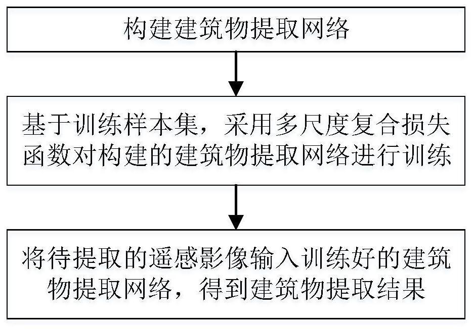
[0040] like figure 1 As shown, a method for accurately segmenting buildings in remote sensing images, the specific steps are as follows:

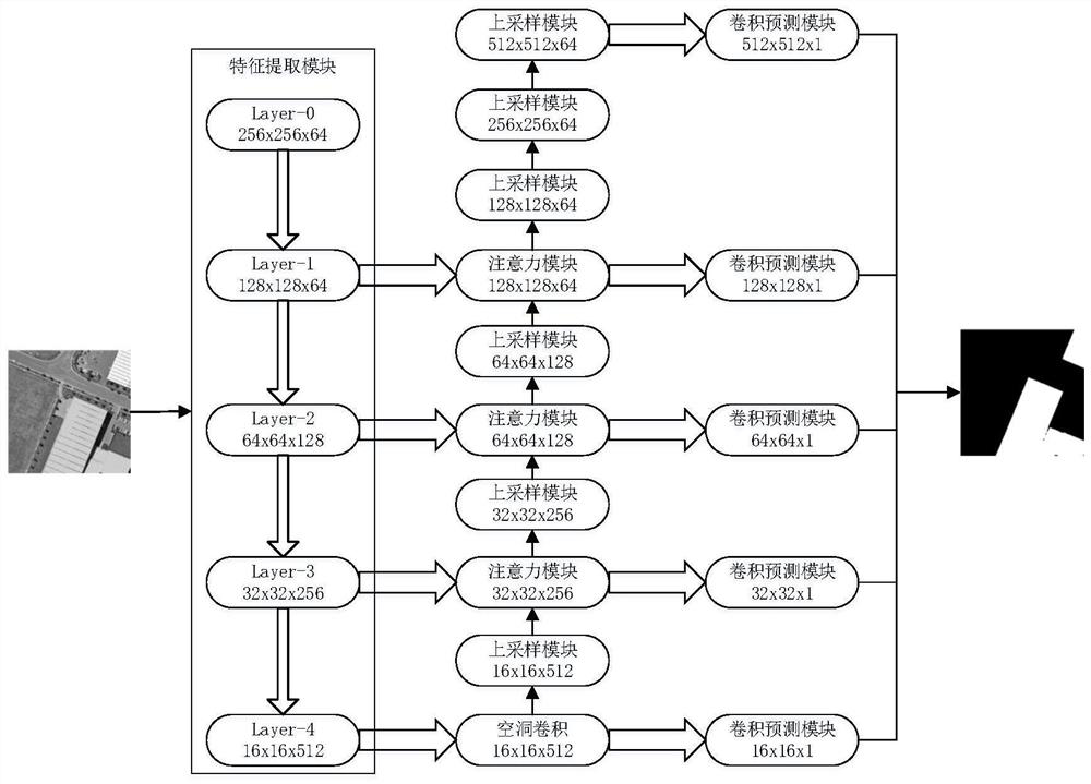
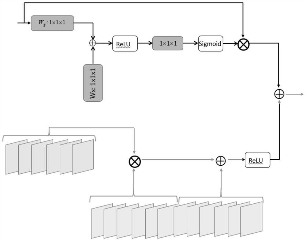
[0041] Step 1: Build a building extraction network including feature extraction module, dilated convolution module, attention module, upsampling module and convolution prediction module, such as figure 2 shown, where:

[0042] The feature extraction module is used to perform multi-scale feature extraction on the input remote sensing image to obtain a multi-scale feature map;

[0043] Specifically, the specific process of the feature extraction module performing multi-scale feature extraction on the input remote sensing image is as follows:

[0044] The pre-trained residual network without the fully connected layer in the building extraction network is used as ...


PUM


Abstract

The invention discloses a method for accurately segmenting buildings in remote sensing images. , using the multi-scale compound loss function combined with Dice Loss and BCE Loss to train the constructed building extraction network; input the remote sensing image to be extracted into the trained building extraction network to obtain the building extraction result. Its remarkable effect is: feature learning, strong generalization ability; low network complexity, easy to train; high precision of building extraction.

Description

technical field [0001] The invention relates to the technical field of automatic extraction of remote sensing image information, in particular to a method for accurately segmenting remote sensing image buildings. Background technique [0002] Building extraction is a classic problem in the field of automatic extraction of remote sensing image information. Its main purpose is to identify and extract building areas in remote sensing images. The results of building extraction are widely used in many fields, such as military reconnaissance, environmental protection, cartography and geographic analysis, etc. Therefore, building extraction has important research value. [0003] Most of the traditional methods use recognition algorithms based on the linear features of building edges. This type of method has the advantages of simplicity and high efficiency, but has defects such as low recognition rate and many errors. Such methods often cause misjudgment of building shadows, and l...

Claims


Application Information

Patent Timeline
Patent Type & Authority Patents(China)
IPC IPC(8): G06T7/00G06T7/11G06K9/46G06N3/04G06N3/08
CPCG06T7/0002G06T7/11G06N3/08G06T2207/10032G06T2207/20016G06T2207/20081G06T2207/20084G06T2207/30184G06V10/44G06N3/048G06N3/045
Inventor 丁忆张泽烈李朋龙马泽忠吴目宇胡翔云胡艳肖禾张觅李晓龙王亚林林熙焦欢黄潇莹彭婧
Owner CHONGQING GEOMATICS & REMOTE SENSING CENT
Why Eureka
Try Eureka