Novel multi-source satellite altimeter fusion method

A fusion method and altimeter technology, applied in the new multi-source satellite altimeter fusion field, can solve the problem of not reaching the maximum effective resolution, and achieve the effect of improving the effective resolution

Pending Publication Date: 2021-06-04
NAT UNIV OF DEFENSE TECH
View PDF0 Cites 0 Cited by
  • Summary
  • Abstract
  • Description
  • Claims
  • Application Information

AI Technical Summary

Problems solved by technology

[0003] There are as many as 5 altimeter satellites currently in orbit. According to the 23-day satellite trajectory distribution of each satellite, the largest blank area in some sea areas not covered by satellite orbits is between 45km and 80km, and the effective resolution of AVISO in this sea area Only 2

Method used


Image

  • Novel multi-source satellite altimeter fusion method
  • Novel multi-source satellite altimeter fusion method
  • Novel multi-source satellite altimeter fusion method

Examples


Embodiment

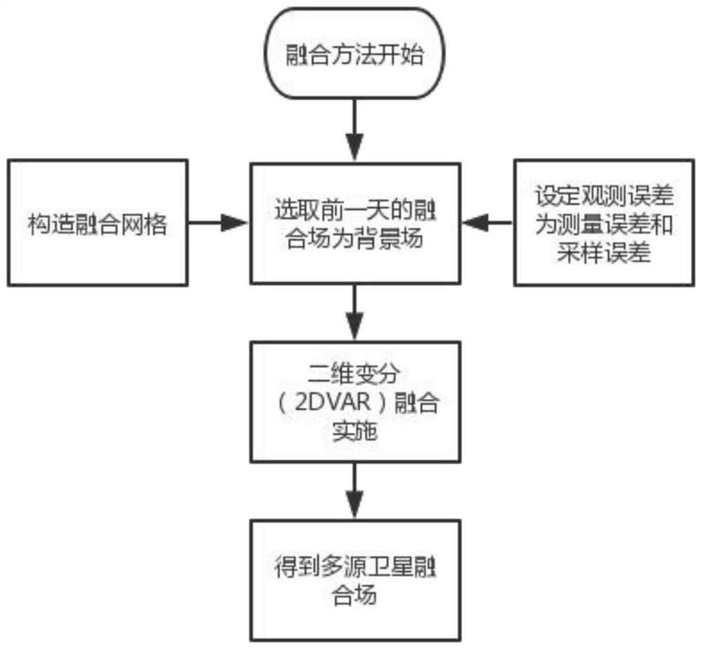
[0048] 1) Select a certain sea area and its adjacent sea area as the research area: 100°~130°E, 0°~26°N. In order to improve the effective resolution, the background grid uses a grid pitch of 0.08° (the grid pitch of AVISO fusion products is 0.25°).

[0049] 2) In the quality control of the input data, in order to detect false values ​​in the altimeter observation, the threshold value is selected for quality control, and the error measurement detection standards along the non-repeating orbit and the new repeating orbit are strictly screened, and they are kept near the coast as much as possible Valid measurement data.

[0050] 3) In the data acquisition process, the height fields obtained from different altimeter satellites have been homogenized, but due to the existence of instrument errors, orbital residual errors, and processing errors, multi-satellite cross-calibration is still required.

[0051] 4) The integration time period is half a year from January 2018 to June 2018....


PUM


Abstract

The invention discloses a novel multi-source satellite altimeter fusion method. The method comprises the steps of decomposing a background error covariance matrix B = sigma C sigma by adopting a diagonal matrix and a correlation coefficient matrix based on an optimal algorithm of two-dimensional variation, estimating and constructing background error correlation by utilizing a Gaussian function, fitting Gaussian distribution through a least square method, obtaining background error correlation coefficient scale, adopting a multi-time satellite altimeter to observe the density to determine the fusion duration, and fusing observation data to obtain a fusion product. According to the method, a two-dimensional variational method is taken as a fusion basis, evolution errors of same-orbit observation are considered, background error covariance correlation coefficient scales are selected according to the altimeter observation density, a more reasonable background error correlation coefficient representation function is constructed, changes of background error correlation coefficient scales of different areas are considered, and the fusion field of the previous day is used as the background field, so that more small-scale signals are reserved in the fusion product, and the effective resolution of the fusion product is remarkably improved.

Description

technical field [0001] The invention relates to the technical field of fusion of multi-source marine satellite altimeter data, in particular to a novel multi-source satellite altimeter fusion method. Background technique [0002] AVISO's altimeter data fusion system has produced and released the most influential satellite altimeter product in the world. Since May 2015, the system has been in charge of the European Copernicus program. Produced and released by service organizations, among them, the DT2018 product released by CMEMS is mainly aimed at the global or regional scale ocean model and mesoscale signal retrieval in ocean circulation analysis, using all altimeter satellite data, with more accurate sea surface height accuracy ; [0003] There are as many as 5 altimeter satellites currently in orbit. According to the 23-day satellite trajectory distribution of each satellite, the largest blank area in some sea areas not covered by satellite orbits is between 45km and 80k...

Claims


Application Information

Patent Timeline
IPC IPC(8): G01S19/14
CPCG01S19/14
Inventor 刘磊蒋星亮李志锦费建芳叶芳王辉赞程小平
Owner NAT UNIV OF DEFENSE TECH
Why Eureka
Try Eureka