Self-adaptive vehicle-mounted integrated navigation and positioning method

A technology of combined navigation and positioning methods, applied in the field of car navigation, can solve the problems of difficulty in ensuring real-time performance, measurement of noise changes, large amount of calculation, etc. gain effect

Pending Publication Date: 2021-07-02
苏州华米导航科技有限公司
View PDF0 Cites 6 Cited by
  • Summary
  • Abstract
  • Description
  • Claims
  • Application Information

AI Technical Summary

Problems solved by technology

[0004] Based on the above analysis, Kalman filter technology can be used to fuse satellite positioning and inertial positioning to obtain vehicle position information and speed information in various environments, so as to achieve high-performance navigation and positioning. However, a large number of studies have shown that, In the low-cost integrated navigation system, the satellite receiver will be interfered by buildi

Method used


Image

  • Self-adaptive vehicle-mounted integrated navigation and positioning method
  • Self-adaptive vehicle-mounted integrated navigation and positioning method
  • Self-adaptive vehicle-mounted integrated navigation and positioning method

Examples


Embodiment Construction

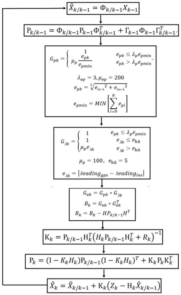
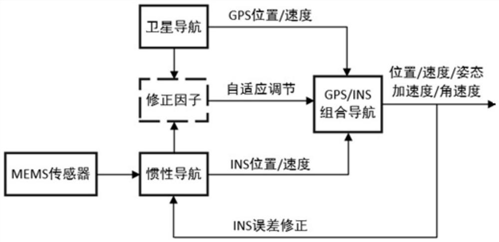
[0129]The purpose of the present invention is to solve the shortcomings of the existing integrated navigation method, and adopt an adaptive Kalman filter algorithm to realize high-precision information such as vehicle position, speed, attitude, acceleration and angular velocity. The divergence of the Kalman filter algorithm caused by the change of environmental noise improves the robustness and accuracy of integrated navigation.

[0130] The adaptive integrated navigation method of the patent of the present invention comprises the following steps:

[0131] Step 1: Determine the state variables and observed variables of the integrated navigation system. The latitude and longitude error, velocity error, attitude error, gyroscope error, and acceleration error are used as state variables, and the position and velocity differences between satellite positioning and inertial navigation positioning are used as observation variables.

[0132] The state variable is

[0133]

[0134...


PUM


Abstract

The invention discloses a self-adaptive vehicle-mounted integrated navigation and positioning method, which comprises the steps of performing multi-sensor information fusion on a satellite positioning system and a strapdown inertial navigation system, constructing an adjustment factor according to factors such as satellite positioning quality on the basis of a standard integrated navigation system, and performing real-time self-adaptive adjustment on a system observation noise array, that is, constructing a self-adaptive GPS/INS Kalman filtering algorithm, thereby being capable of obtaining the position, the speed, the attitude, the acceleration, the angular velocity and other information of the high-precision vehicle in any complex environment. The method is high in real-time performance and good in robustness.

Description

technical field [0001] The invention relates to the technical field of car navigation, in particular to an adaptive vehicle integrated navigation positioning method. Background technique [0002] Satellite navigation is currently the most widely used positioning technology, with high positioning and speed measurement accuracy, and good long-term working stability. However, in many complex environments (underpasses, tunnels, garages), satellite positioning often has problems such as multipath interference, satellite signals being blocked or out of lock, or even unable to locate or have large positioning errors, so it cannot work. [0003] Strapdown inertial navigation system, referred to as inertial navigation system, is a completely autonomous navigation system. It can continuously provide information such as the position, velocity, attitude, acceleration and angular velocity of the carrier. It has good stability in a short time, is easy to use, and is low in cost. [0004]...

Claims


Application Information

Patent Timeline
IPC IPC(8): G01C21/34G01C21/16G01S19/47
CPCG01C21/3415G01C21/165G01S19/47
Inventor 高同跃
Owner 苏州华米导航科技有限公司
Why Eureka
Try Eureka