
Expansive soil area earth surface deformation monitoring method based on time sequence InSAR technology

A technology for surface deformation and expansive soil, which is applied in the directions of measuring devices, radio wave measurement systems, radio wave reflection/re-radiation, etc., can solve the problems of high labor and equipment costs, difficulty in obtaining large-area overall deformation distribution in expansive soil areas, etc. , to achieve the effects of easy analysis and interpretation, easy and quick acquisition, and no omission of deformation information

Pending Publication Date: 2021-07-02
CHANGAN UNIV
View PDF2 Cites 4 Cited by
  • Summary
  • Abstract
  • Description
  • Claims
  • Application Information

AI Technical Summary

Problems solved by technology

At present, there are GNSS measurement, leveling and layered calibration technologies for surface deformation monitoring in expansive soil areas. The above-mentioned technical solutions can obtain discrete and high-precision point position deformation variables, but due to their high labor and equipment costs, they are affected by terrain factors. It is restricted and difficult to obtain the large-area overall deformation distribution of the expansive soil area, so a high-precision, large-scale, long-period deformation monitoring technology is required

Method used


Image

  • Expansive soil area earth surface deformation monitoring method based on time sequence InSAR technology
  • Expansive soil area earth surface deformation monitoring method based on time sequence InSAR technology
  • Expansive soil area earth surface deformation monitoring method based on time sequence InSAR technology

Examples


Embodiment Construction

[0035] The technical solutions of the embodiments of the present invention will be clearly and completely described below in conjunction with the accompanying drawings in the present invention. Obviously, the described embodiments are part of the embodiments of the present invention, not all of them. Based on the embodiments of the present invention, all other embodiments obtained by persons of ordinary skill in the art without making creative efforts shall fall within the protection scope of the present invention.

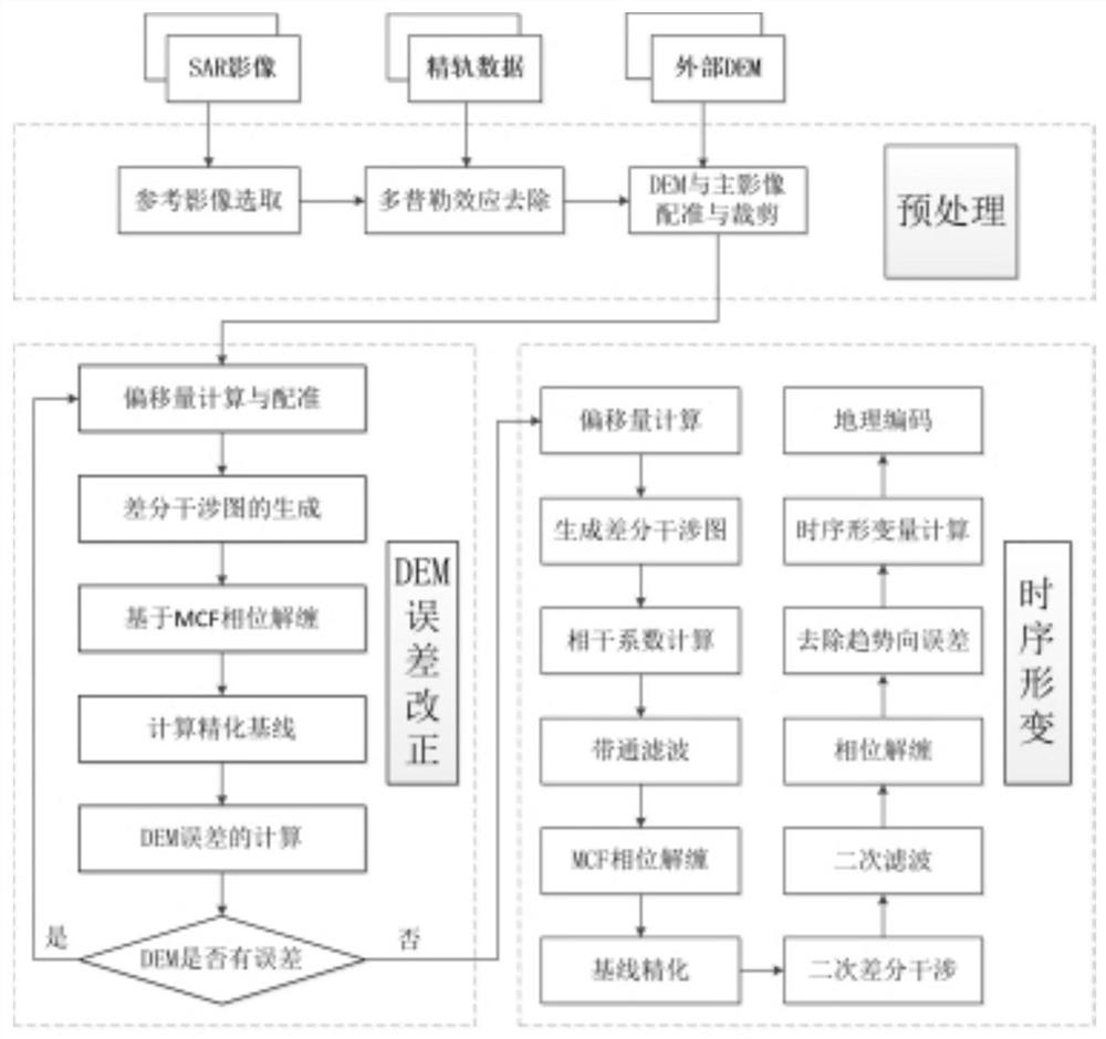
[0036] refer to Figure 1-4 , the present invention provides a method for monitoring surface deformation in expansive soil regions based on time-series InSAR technology, comprising the following steps:

[0037] Step S1: Preprocess the SAR image data provided by Sentinrl-1A covering the study area by using the Sentinrl-1A precise orbit data and digital elevation model DEM provided by ESA;

[0038] Step S2: From the preprocessing results, select the SAR image data ...


PUM


Abstract

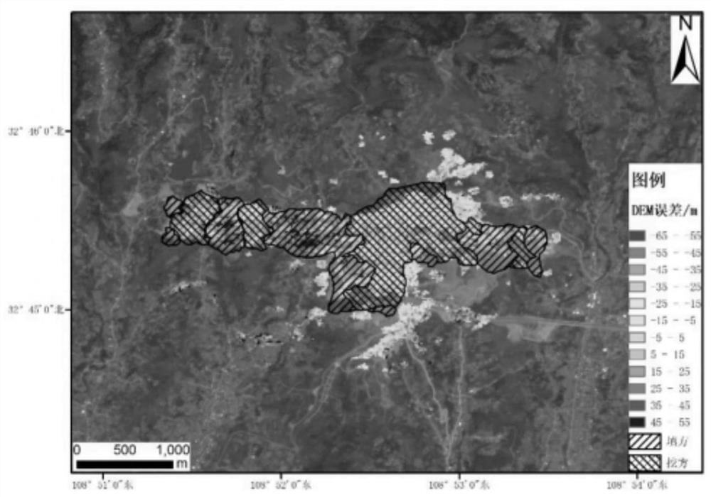
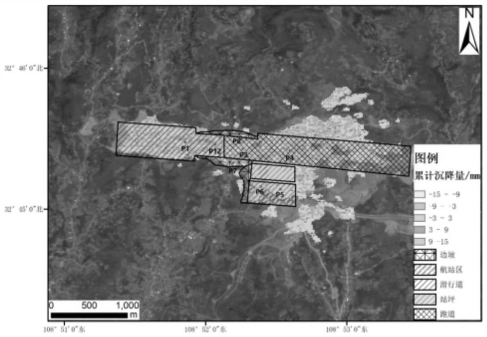
The invention discloses an expansive soil area surface deformation monitoring method based on a time sequence InSAR technology, and relates to the technical field of deformation monitoring. Spaceborne synthetic aperture radar data is used, firstly, an existing digital elevation model error is calculated and corrected by using an SBAS-InSAR (small baseline integrated aperture radar interferometry) technology; after a DEM (digital elevation model) product is iteratively updated, the SBAS-I nSAR technology is adopted to carry out deformation monitoring on an anglerkang airport, the fill expansive soil layer depth distribution in an expansive soil area is obtained according to DEM error information and serves as a deformation auxiliary judgment means, and large-range and high-precision periodic time sequence deformation information of the expansive soil area is obtained. And the used multi-source remote sensing data is simple and fast to obtain, the efficiency is high, and the manpower and material resource cost is extremely low.

Description

technical field [0001] The invention relates to the technical field of deformation monitoring, in particular to a method for monitoring surface deformation in expansive soil regions based on time-series InSAR technology. Background technique [0002] In recent years, due to the special hydraulic characteristics of expansive soils and the wide distribution of expansive soils, monitoring regional surface deformation of expansive soils has been a hot topic. At present, there are GNSS measurement, leveling and layered calibration technologies for surface deformation monitoring in expansive soil areas. The above technical solutions can obtain discrete and high-precision point deformation variables, but due to their high labor and equipment costs, they are affected by terrain factors. It is restricted and difficult to obtain the large-area overall deformation distribution of the expansive soil area, so a high-precision, large-scale, long-period deformation monitoring technology is...

Claims


Application Information

Patent Timeline
Patent Type & Authority Applications(China)
IPC IPC(8): G01S13/90G01S13/88G01S7/41
CPCG01S13/9023G01S13/885G01S7/41
Inventor 张双成司锦钊朱武牛玉芬袁敏刘宁王霞迎樊茜佑安鹏庞校光许强
Owner CHANGAN UNIV
Learn More