Transformer substation geological deformation monitoring method based on SAR satellite and Beidou satellite

A Beidou satellite and substation technology, applied in electric/magnetic solid deformation measurement, satellite radio beacon positioning system, electromagnetic measurement device, etc., can solve problems such as limited scope and inability to implement monitoring, so as to improve the level and quality, The effect of ensuring operational safety

Pending Publication Date: 2021-07-02
STATE GRID ZHEJIANG ELECTRIC POWER +2
View PDF0 Cites 9 Cited by
  • Summary
  • Abstract
  • Description
  • Claims
  • Application Information

AI Technical Summary

Problems solved by technology

However, InSAR observation has a certain revisit cycle, and it can only be monitored at a certain time interval, and it cannot be implemented.
The Beidou monitoring technology has the advantages of real-time monitoring, but it only monitors a single point, and the scope is very limited

Method used


Image

  • Transformer substation geological deformation monitoring method based on SAR satellite and Beidou satellite

Examples


Embodiment 1

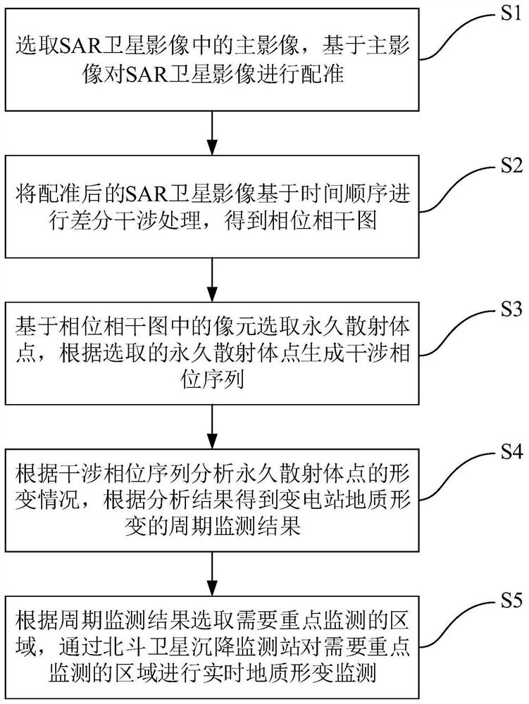
[0051] Such as figure 1 As shown, the present invention proposes a substation geological deformation monitoring method based on SAR satellite and Beidou satellite, including:

[0052] S1: Select the main image in the SAR satellite image, and register the SAR satellite image based on the main image.

[0053] SAR satellite is a technology that uses SAR time-series image data observed in the same area for coherent processing, and obtains surface elevation information and deformation information through phase information. The application in geological disaster monitoring and early warning has gradually matured. It has incomparable advantages in measuring surface deformation and displacement and monitoring ground dynamic changes. It has high resolution, high precision, wide coverage, and is not cloudy, rainy and snowy impact, long monitoring cycle and other advantages. When using SAR satellites for large-scale deformation monitoring, it is first necessary to preprocess the SAR sa...


PUM


Abstract

The invention provides a transformer substation geological deformation monitoring method based on an SAR satellite and a Beidou satellite, and the method comprises the steps: selecting a main image in SAR satellite images, and carrying out the registration of the SAR satellite images based on the main image; performing differential interference processing on the registered SAR satellite image based on a time sequence to obtain a phase coherence graph; selecting permanent scatterer points based on pixels in the phase coherence graph, and generating an interference phase sequence according to the selected permanent scatterer points; analyzing the deformation condition of the permanent scatterer points according to the interferometric phase sequence to obtain a periodic monitoring result of the geological deformation of the transformer substation; and according to a periodic monitoring result, selecting an area which needs to be monitored emphatically, and carrying out real-time geological deformation monitoring on the area which needs to be monitored emphatically through a Beidou satellite settlement monitoring station. The SAR satellite and the Beidou satellite are combined to maximize the monitoring effect, and the geological deformation monitoring level and quality of the transformer substation in China are improved.

Description

technical field [0001] The invention belongs to the field of geological monitoring, in particular to a substation geological deformation monitoring method based on SAR satellite and Beidou satellite. Background technique [0002] Land subsidence refers to a geological phenomenon in which the underground loose rock layer is consolidated and compressed due to natural factors or human engineering activities, resulting in a decrease in ground elevation in a certain area. It is a slowly changing geological disaster. Especially in provinces where land subsidence is more serious in my country, the land subsidence tends to intensify, which has a direct impact on power facilities such as substations and transmission lines. Seriously affect the safe operation of the substation. [0003] Since geological deformation is often in the early stage of development, the deformation is relatively small, generally at the mm-cm level, and it is not easy to find. In addition, due to the late dev...

Claims


Application Information

Patent Timeline
Patent Type & Authority Applications(China)
IPC IPC(8): G01S19/42G01B7/16
CPCG01B7/16G01S19/42
Inventor 许飞谢金华赵铮张波张玉和刘文涛邸登坡巴红霞
Owner STATE GRID ZHEJIANG ELECTRIC POWER
Why Eureka
Try Eureka