Structure-enhanced semi-supervised online map generation method

A map generation and structure enhancement technology, applied in 2D image generation, image data processing, instruments, etc., can solve the problem of high error rate in map generation

Inactive Publication Date: 2021-07-06
湖北星地智链科技有限公司
View PDF2 Cites 2 Cited by
  • Summary
  • Abstract
  • Description
  • Claims
  • Application Information

AI Technical Summary

Problems solved by technology

[0007] Aiming at the deficiencies of the prior art, the present invention provides a structure-enhanced semi-supervised online map generation method, which solves the problem of high error rate in map generation

Method used


Image

  • Structure-enhanced semi-supervised online map generation method
  • Structure-enhanced semi-supervised online map generation method
  • Structure-enhanced semi-supervised online map generation method

Examples


Embodiment 1

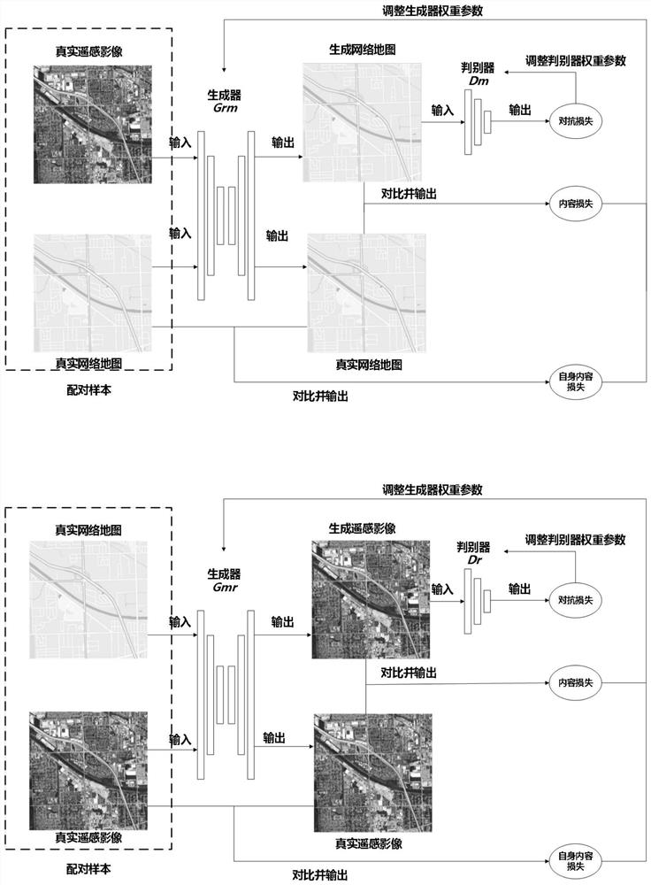
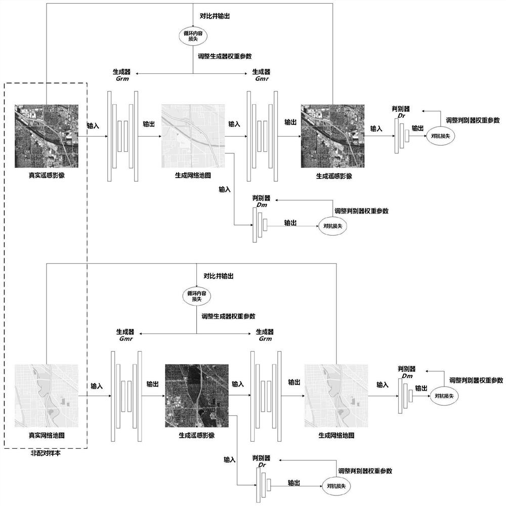
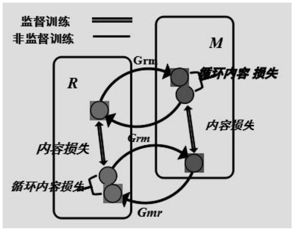
[0043] like Figure 1-3 As shown, the embodiment of the present invention provides a structure-enhanced semi-supervised online map generation method, which is characterized in that it includes the following specific steps:

[0044] Step 1: Use the existing remote sensing images and map datasets, or use the API provided by Google Maps to obtain the two image resources of remote sensing images and ready-made maps and standardize them. There are some samples between the two image resources obtained The mapping relationship, according to whether it is paired or not, is divided into paired samples and unpaired samples through the file organization structure, and a semi-supervised training data set is constructed.

[0045] Step 2: Use the Structure-guided Semi-Supervised Online Map Automatic Generating Model Based on GAN model (S2OM for short) to learn the semi-supervised training data set.

[0046] Step 3: Input other standardized remote sensing images, and use the S2OM model for ...


PUM


Abstract

The invention provides a structure-enhanced semi-supervised online map generation method, and relates to the technical field of online maps. The structure-enhanced semi-supervised online map generation method comprises the following specific steps: acquiring two image resources of a remote sensing image and an instant map by using an existing remote sensing image and a map data set or through an API provided by a Google map, and carrying out standardization processing, so that a mapping relation of partial samples exists between the two acquired image resources; and according to whether pairing is carried out or not, dividing the samples into pairing samples and non-pairing samples through a file organization structure, and constructing a semi-supervised training data set. According to the method, a semi-supervised training method following circulation consistency is established, available resources are more fully applied, structural characteristics of CyclGAN and Pix2Pix are combined, a semi-supervised learning strategy of S2OM is created, paired samples and non-paired samples are learned in stages, model learning is more sufficient, and the map generation error rate is lower.

Description

technical field [0001] The invention relates to the technical field of online maps, in particular to a structure-enhanced semi-supervised online map generation method. Background technique [0002] The conversion of remote sensing images to online map services is a process in which spatial information is transferred from the carrier of remote sensing images to the carrier of maps. image process. Image-to-image conversion refers to converting an image distributed in the original content domain into a corresponding image in the target content domain. The latest image-to-image conversion method makes full use of the Generative Adversarial Network (GAN) to establish image feature expression. Learning feature mapping and image transformation methods, and achieved good results. A typical generative confrontation network consists of a generator and a discriminator. The generator learns to generate fake samples with the same characteristics as real samples, and the discriminator l...

Claims


Application Information

Patent Timeline
Patent Type & Authority Applications(China)
IPC IPC(8): G06K9/00G06K9/62G06T11/20
CPCG06T11/206G06V20/13G06F18/214
Inventor 耿江屹高晨婧
Owner 湖北星地智链科技有限公司
Why Eureka
Try Eureka