Combined surveying and mapping instrument positioning and adjusting device for geological engineering surveying and mapping

A positioning adjustment and combined technology, which is applied in the field of surveying and mapping, can solve the problems of inability to achieve stepless adjustment, limited adjustment range, and reduced locking degree, and achieves the effect of compact structure, ensuring stability and reducing the difficulty of use.

Active Publication Date: 2021-07-09
SANMENXIA POLYTECHNIC
View PDF18 Cites 1 Cited by
  • Summary
  • Abstract
  • Description
  • Claims
  • Application Information

AI Technical Summary

Problems solved by technology

For the method of bolt locking, the bolt needs to be loosened and tightened every time the length is adjusted, which is inconvenient to use when the adjustment is relatively frequent. At the same time, after long-term use, the locking degree is often reduced due to loose bolts. Affects normal surveying and mapping; for the method of locking with elastic buttons, the adjustment range is mainly controlled by the button hole that is matched with the setting, and stepless adjustment cannot be achieved, and the adjustment range is limited

Method used


Image

  • Combined surveying and mapping instrument positioning and adjusting device for geological engineering surveying and mapping
  • Combined surveying and mapping instrument positioning and adjusting device for geological engineering surveying and mapping
  • Combined surveying and mapping instrument positioning and adjusting device for geological engineering surveying and mapping

Examples


Embodiment Construction

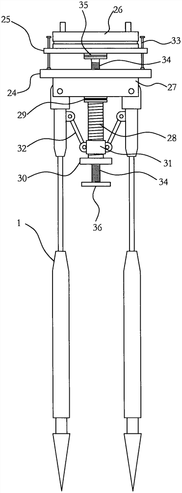
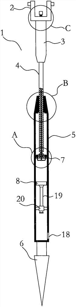
[0024] Such as Figure 1-5 As shown, a combined surveying and mapping instrument positioning adjustment device for geological engineering surveying and mapping is similar to a traditional surveying and mapping device, and also includes a tripod and a surveying and mapping instrument main body that is also arranged on the tripod. The tripod includes a top platform and is arranged on the top. Three support legs 1 hinged with the top platform on the peripheral side of the platform. This is the prior art, which will not be repeated in the present invention.

[0025] Such as figure 1 As shown, the top platform of the present invention includes a bottom plate 24 and a top plate 25, and the top plate 25 and the bottom plate 24 are installed horizontally one above the other. The top plate 25 is provided with a swivel seat 26 for installing the main body of the surveying and mapping instrument. The swivel seat 26 can be manually rotated, which is low in cost and easy to maintain, or ...


PUM


Abstract

The invention relates to the technical field of surveying and mapping. The invention provides a combined surveying and mapping instrument positioning and adjusting device for geological engineering surveying and mapping, which comprises a tripod and a surveying and mapping instrument body arranged on the tripod, and the tripod comprises a top platform and three supporting legs which are arranged on the peripheral side of the top platform and hinged to the top platform; the top platform comprises a bottom plate and a top plate, and the top plate is provided with a rotating seat used for installing a surveying and mapping instrument body; a connecting block is arranged on the lower surface of the bottom plate, and the upper ends of the three supporting legs are hinged to the connecting block; a vertical outer threaded pipe is arranged in the center of the lower surface of the connecting block, the upper end of the outer threaded pipe is connected with the connecting block through a first rotating connector, and a first screwing head is arranged at the lower end of the outer threaded pipe. High-precision synchronous opening and closing of the multiple supporting legs can be achieved, use is convenient, and positioning is accurate.

Description

technical field [0001] The invention relates to the technical field of surveying and mapping, in particular to a combined surveying and mapping instrument positioning adjustment device for geological engineering surveying and mapping. Background technique [0002] Surveying and mapping equipment is a kind of equipment that needs to be frequently used in geological engineering design and construction. Commonly used surveying and mapping equipment includes theodolite, level, total station, vernier caliper, screw caliper, etc. In the actual application process, some surveying and mapping equipment such as theodolite and total station need to be used with a tripod to ensure the accuracy of its measurement. At present, traditional tripods usually include three supporting legs and an installation platform mounted on the upper ends of the supporting legs, on which surveying and mapping equipment is installed for use. In order to meet the needs of different terrains, different supp...

Claims


Application Information

Patent Timeline
Patent Type & Authority Applications(China)
IPC IPC(8): G01D11/30
CPCG01D11/30
Inventor 杨阿兰
Owner SANMENXIA POLYTECHNIC
Why Eureka
Try Eureka