
Fixed-wing unmanned aerial vehicle for surveying and mapping

An unmanned aerial vehicle and fixed-wing technology, which is applied to the field of fixed-wing unmanned aerial vehicles for surveying and mapping, can solve the problems of difficulty in aerial surveying tasks of unmanned aerial vehicles with large aspect ratio and difficult aerial surveying tasks of unmanned aerial vehicles with small aspect ratio, so as to improve the use economy. sex, prolong the void time, reduce the effect of the impact

Inactive Publication Date: 2021-07-23
余屹
View PDF6 Cites 0 Cited by
  • Summary
  • Abstract
  • Description
  • Claims
  • Application Information

AI Technical Summary

Problems solved by technology

[0005] Aiming at the deficiencies of the prior art, the present invention provides a fixed-wing unmanned aerial vehicle for surveying and mapping to solve the problem that it is difficult for a large-aspect-ratio unmanned aerial vehicle to perform aerial survey tasks in windy weather, and it is difficult for a small-aspect-ratio unmanned aerial vehicle to perform aerial survey tasks. The Problem of Carrying out Aerial Survey Missions Economically at Lower Flight Speeds

Method used


Image

  • Fixed-wing unmanned aerial vehicle for surveying and mapping
  • Fixed-wing unmanned aerial vehicle for surveying and mapping
  • Fixed-wing unmanned aerial vehicle for surveying and mapping

Examples


Embodiment Construction

[0027] The following will clearly and completely describe the technical solutions in the embodiments of the present invention with reference to the accompanying drawings in the embodiments of the present invention. Obviously, the described embodiments are only some, not all, embodiments of the present invention. Based on the embodiments of the present invention, all other embodiments obtained by persons of ordinary skill in the art without making creative efforts belong to the protection scope of the present invention.

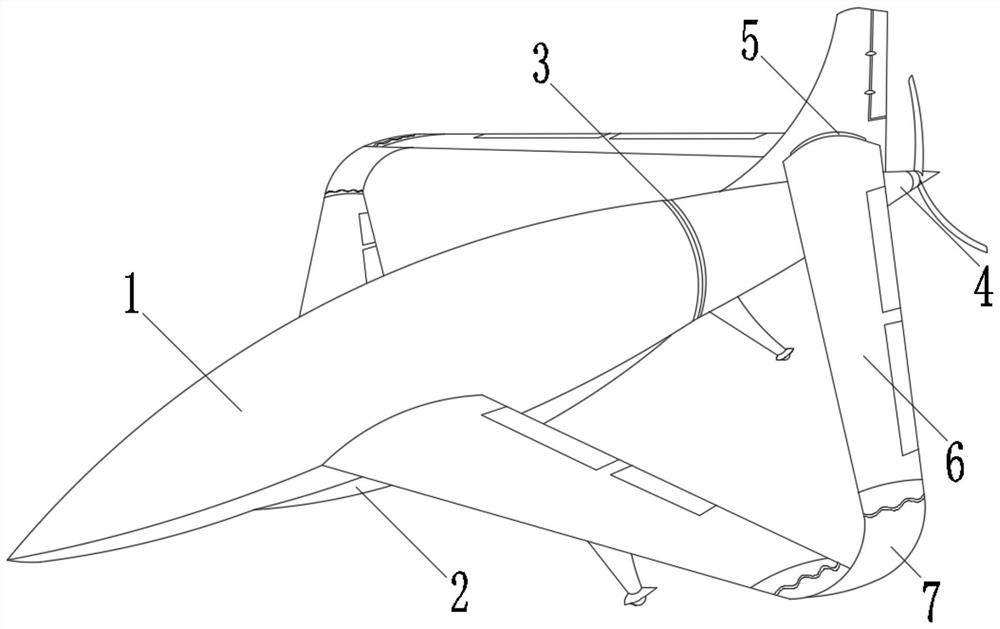
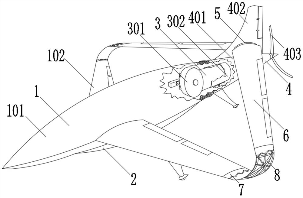
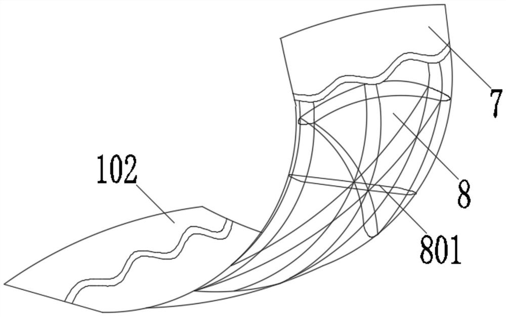
[0028] Such as Figure 1-5As shown, the present invention provides a technical solution: a fixed-wing unmanned aerial vehicle for surveying and mapping, including a front body 1, a conformal surveying and mapping pod 2, a fuselage deformation device 3, a rear body 4, a connecting rotating device 5, and a rear wing 6. The semi-rigid transition wing section 7 and the variable curved dish-shaped polyhedron frame 8, the conformal surveying and mapping pod 2 is arr...


PUM


Abstract

The invention discloses a fixed-wing unmanned aerial vehicle for surveying and mapping, which comprises a front vehicle body, a shape-preserving surveying and mapping pod, a vehicle body deformation device, a rear vehicle body, a connection rotating device, a rear wing, a semi-rigid transition wing section and a bendable dish-shaped polyhedral frame, the shape-preserving surveying and mapping pod is arranged at the bottom of the front vehicle body, and the vehicle body deformation device is arranged at the rear part of the front vehicle body; the invention relates to the technical field of engineering surveying and mapping. According to the fixed-wing unmanned aerial vehicle for surveying and mapping, a variable connecting wing pneumatic layout and a rear power and front three-point type shape correction undercarriage layout are adopted, and the problems that an unmanned aerial vehicle with a high aspect ratio is difficult to execute aerial survey tasks in weather with large wind power and an unmanned aerial vehicle with a small aspect ratio is difficult to economically execute aerial survey tasks at a low flight speed can be solved; the unmanned aerial vehicle executes an aerial survey task in the mode of the minimum sweepforward angle and the maximum aspect ratio so as to prolong the space time and improve the use economy, and when the low-altitude wind power is increased, the unmanned aerial vehicle continues to work in the mode of the small aspect ratio.

Description

technical field [0001] The invention relates to the technical field of engineering surveying and mapping, in particular to a fixed-wing unmanned aerial vehicle for surveying and mapping. Background technique [0002] UAV aerial survey is a powerful supplement to traditional aerial photogrammetry. It has the characteristics of flexible maneuverability, high efficiency and speed, precision and accuracy, low operating cost, wide application range, and short production cycle. It has obvious advantages in terms of acquisition. With the development of UAV and digital camera technology, digital aerial photography technology based on UAV platform has shown its unique advantages. UAV aerial photography can be widely used in major national engineering construction, disaster Emergency response and treatment, land supervision, resource development, construction of new countryside and small towns, etc., especially in basic surveying and mapping, land resource survey and monitoring, land ...

Claims


Application Information

Patent Timeline
Patent Type & Authority Applications(China)
IPC IPC(8): B64C39/02B64C1/06B64C7/00B64C5/06B64C3/38
CPCB64C39/02B64C1/068B64C1/0009B64C7/00B64C5/06B64C3/385B64U10/25
Inventor 余屹
Owner 余屹
Learn More