
Buffer zone automatic segmentation and classification method suitable for winding river and device thereof

A classification method and buffer zone technology, which are applied in structured data retrieval, special data processing applications, database models, etc., can solve problems such as classification result errors and unreasonable buffer zone segmentation, so as to avoid unreasonable segmentation and ensure Classification efficiency and accuracy, to achieve the effect of rapid monitoring

Active Publication Date: 2021-07-23
MINISTRY OF ECOLOGY & ENVIRONMENT CENT FOR SATELLITE APPL ON ECOLOGY ENVIRONMENT
View PDF3 Cites 0 Cited by
  • Summary
  • Abstract
  • Description
  • Claims
  • Application Information

AI Technical Summary

Problems solved by technology

However, the existing buffer zone remote sensing monitoring methods are mostly suitable for rivers with low meandering degree, simple trend and consistent shape on both banks. When applied to meandering rivers with complex shapes, unreasonable segmentation of the buffer zone will occur, resulting in classification results. large error

Method used


Image

  • Buffer zone automatic segmentation and classification method suitable for winding river and device thereof
  • Buffer zone automatic segmentation and classification method suitable for winding river and device thereof
  • Buffer zone automatic segmentation and classification method suitable for winding river and device thereof

Examples


Embodiment 1

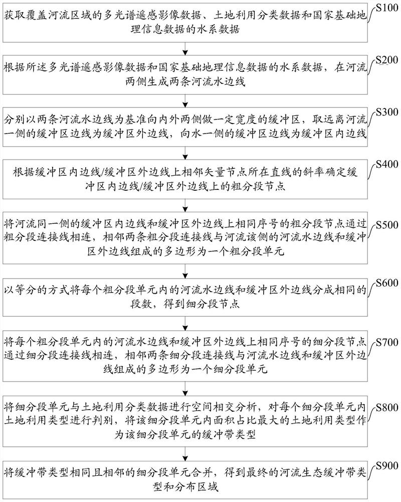
[0074] Embodiments of the present invention provide a buffer zone automatic segmentation and classification method suitable for meandering rivers, such as figure 1 As shown, the method includes:

[0075] S100: Acquire multispectral remote sensing image data covering river areas, land use classification data and water system data of national basic geographic information data.

[0076] The multi-spectral remote sensing image data is preferably the remote sensing imaging data in the wet season of the river. The water system data of the land use classification data and the national basic geographic information data should be consistent with the time phase of the multi-spectral remote sensing image data. The time phase consistency refers to the time gap. As short as possible, it can be all the data in recent years.

[0077] The ratio of water system data in national basic geographic information data is 1:250,000, and the spatial resolution of multispectral remote sensing image dat...

Embodiment 2

[0125] Embodiments of the present invention provide a buffer zone automatic segmentation and classification device suitable for meandering rivers, such as Image 6 As shown, the device includes:

[0126] Data acquisition module 1 is used to acquire multispectral remote sensing image data covering river areas, land use classification data and water system data of national basic geographic information data.

[0127] The river waterline generation module 2 is used to generate two river waterlines on both sides of the river according to the multi-spectral remote sensing image data and the water system data of the national basic geographic information data.

[0128] The buffer generation module 3 is used to make a buffer zone with a certain width on the inside and outside sides based on the water edge of the two rivers, and take the buffer edge on the side far away from the river as the outer edge of the buffer, and the buffer on the water side The edge is the inner edge of the bu...


PUM


Abstract

The invention discloses a buffer zone automatic segmentation and classification method suitable for a winding river and a device thereof, and belongs to the field of river monitoring, and the method comprises the steps: obtaining remote sensing image data, land utilization classification data and water system vector data; determining a river waterline according to the remote sensing image data and the water system data; taking a river waterline as a reference to make a buffer area, and respectively obtaining inner and outer side lines of the buffer areas on two sides; obtaining segment nodes of inner and outer edge lines of a buffer zone, and dividing the buffer zone into a plurality of coarse segment units; segmenting an inland river running water side line and a buffer area outer side line of the buffer area coarse segmentation unit in an equal division manner, and dividing the coarse segmentation unit into a plurality of fine segmentation units; according to the land utilization classification data, judging the land utilization occupation condition in each subdivision section unit, and determining the river buffer zone classification condition. The method performs automatic step-by-step segmentation on the buffer zones on the two sides of the winding river, guarantees the classification efficiency and precision of the buffer zones, and achieves the rapid monitoring of the current situation of the buffer zones of the winding river.

Description

technical field [0001] The invention relates to the field of river monitoring, in particular to a method and device for automatic segmentation and classification of a buffer zone suitable for meandering rivers. Background technique [0002] The river buffer zone is an important carrier of the river ecosystem, and has ecological functions such as preventing and controlling non-point source pollution, protecting water quality, stabilizing river banks, and maintaining species diversity. Obtaining the status quo of the buffer zone and its historical changes is of great significance for the decision-making of water ecological environment management such as the restoration of the buffer zone of the river. [0003] The river buffer zone classification technology based on remote sensing and other spatial information technologies is an effective means of monitoring river buffer zones. Compared with traditional methods such as ground surveys, it greatly improves the efficiency of rive...

Claims


Application Information

Patent Timeline
Patent Type & Authority Applications(China)
IPC IPC(8): G06F16/28G06F16/29
CPCG06F16/285G06F16/29
Inventor 王楠殷守敬王东红聂忆黄王雪蕾周亚明孟斌余嘉琦肖如林王庆涛杨红艳孙浩李营邵圆圆朱南华诺娃
Owner MINISTRY OF ECOLOGY & ENVIRONMENT CENT FOR SATELLITE APPL ON ECOLOGY ENVIRONMENT
Learn More