Agricultural Internet of Things method, system and device based on Beidou positioning module

A Beidou positioning and Internet of Things technology, which is applied in the field of agricultural Internet of Things methods, systems and devices, can solve the problems of positioning coordinate data data transmission disorder, data and real-time data mismatch, etc., and achieve the effect of improving positioning efficiency

Active Publication Date: 2021-07-23
SHANGHAI DATACENT SCI CO LTD
View PDF10 Cites 2 Cited by
  • Summary
  • Abstract
  • Description
  • Claims
  • Application Information

AI Technical Summary

Problems solved by technology

[0003] With the continuous development of science and technology, Beidou satellite navigation technology has been used to

Method used


Image

  • Agricultural Internet of Things method, system and device based on Beidou positioning module
  • Agricultural Internet of Things method, system and device based on Beidou positioning module
  • Agricultural Internet of Things method, system and device based on Beidou positioning module

Examples


Embodiment Construction

[0046] Reference will now be made in detail to the exemplary embodiments, examples of which are illustrated in the accompanying drawings. When the following description refers to the accompanying drawings, the same numerals in different drawings refer to the same or similar elements unless otherwise indicated. The implementations described in the following exemplary embodiments do not represent all implementations consistent with this application. Rather, they are merely examples of apparatuses and methods consistent with aspects of the present application as recited in the appended claims.

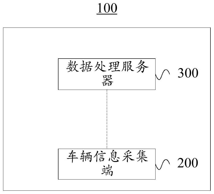
[0047] In order to facilitate the elaboration of the above-mentioned method and device for the agricultural Internet of Things based on the Beidou positioning module, please refer to figure 1 , provides a schematic diagram of the communication architecture of the Beidou positioning module-based agricultural Internet of Things system 100 disclosed in the embodiment of the present inventio...


PUM


Abstract

The invention discloses an agricultural Internet of Things method, system and device based on a Beidou positioning module, and the method comprises the steps: obtaining the regional longitude and latitude distribution information of a first agricultural cultivation region, detecting a first simulation space, and transmitting the first agricultural cultivation region to a target cultivation site in the simulation space; using a target cultivation site in the simulation space as initial longitude and latitude, generating a geographic coordinate track and initial longitude and latitude of geographic coordinates in the simulation space, and the initial longitude and latitude of the geographic coordinates belonging to the geographic coordinate track. A first agricultural cultivation area with a positional relationship is provided, the first agricultural cultivation area has a geographic coordinate trajectory and an initial latitude and longitude of geographic coordinates, a distance between a second simulation space located in the geographic coordinate trajectory and a target cultivation site is detected, and an initial point is made at the initial latitude and longitude of the geographic coordinates. And a simulation space is established to construct a whole coordinate system, so that the situation that spatial position attributes are matched for a long time is avoided, and the positioning efficiency of the agricultural Internet of Things is improved.

Description

technical field [0001] This application relates to the technical field of agricultural Internet of Things positioning, in particular to methods, systems and devices for agricultural Internet of Things based on the Beidou positioning module. Background technique [0002] The Beidou satellite navigation system is a high-precision, all-weather and global multifunctional system for radio navigation, positioning and timing. Beidou satellite navigation technology has developed into a multi-field, multi-mode, multi-purpose, multi-model international high-tech industry. The Beidou satellite navigation system consists of three parts: the space part, the ground measurement and control part and the user equipment. [0003] With the continuous development of science and technology, Beidou satellite navigation technology has been used to locate agricultural farming areas for agricultural location positioning. A situation where the data and real-time data do not match. Contents of the...

Claims


Application Information

Patent Timeline
IPC IPC(8): G06F16/29G06F16/9537G06F16/909G16Y10/05G16Y20/10
CPCG06F16/29G06F16/9537G06F16/909G16Y10/05G16Y20/10Y02A40/10
Inventor 费晓霞
Owner SHANGHAI DATACENT SCI CO LTD
Why Eureka
Try Eureka