
A method and system for automatic identification of line crossing points based on geographic information

A technology of geographic information and line crossing, applied in the field of power system transmission line design, can solve problems such as hidden dangers, easy omissions, and difficult to record information update, and achieve the effect of ensuring accuracy

Active Publication Date: 2021-12-10
广东信通通信有限公司
View PDF0 Cites 0 Cited by
  • Summary
  • Abstract
  • Description
  • Claims
  • Application Information

AI Technical Summary

Problems solved by technology

During the construction of transmission lines, due to the complex geographical environment of the construction site, the path of transmission lines inevitably intersects with geographical information lines such as roads, railways, bridges, and rivers. When the transmission line is damaged due to high frequency, there are certain potential safety hazards, which need to be paid attention to. At this time, the safety inspection of these intersections can only be carried out by manually recording the intersection positions and regular inspections. This method can be used to a certain extent. To alleviate the potential safety hazards of transmission lines, the problem of untimely discovery, but the manual inspection records in the early stage took a long time, and due to the rapid construction of basic geographic information lines in my country, the efficiency of manual recording of intersection positions is very low, and it is difficult to timely record Information is updated, and it is easy to miss

Method used


Image

  • A method and system for automatic identification of line crossing points based on geographic information
  • A method and system for automatic identification of line crossing points based on geographic information
  • A method and system for automatic identification of line crossing points based on geographic information

Examples


Embodiment 1

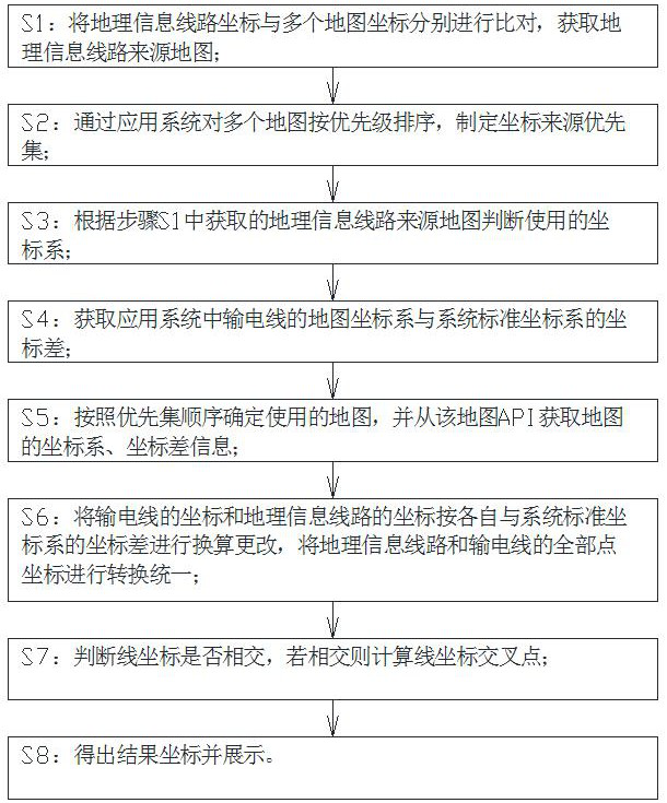
[0040] An automatic identification method for line crossing points based on geographical information, comprising the following steps:

[0041] S1: Compare the geographic information line coordinates with multiple map coordinates to obtain the geographic information line source map;

[0042] S2: Prioritize multiple maps through the application system, and formulate a priority set of coordinate sources;

[0043] S3: judging the coordinate system used according to the geographical information line source map obtained in step S1;

[0044] S4: Obtain the coordinate difference between the map coordinate system of the transmission line in the application system and the system standard coordinate system;

[0045] S5: Determine the map to be used according to the order of the priority set, and obtain the coordinate system and coordinate difference information of the map from the map API;

[0046] S6: Convert the coordinates of the transmission line and the coordinates of the geograph...

Embodiment 2

[0050] An automatic identification method for line crossing points based on geographical information, comprising the following steps:

[0051] S1: Compare the geographic information line coordinates with multiple map coordinates to obtain the geographic information line source map;

[0052] Specifically, firstly, a geographical information line is selected to determine the source map of the line. For example: geographic information line A is judged by coordinate comparison that geographic information line A comes from multiple maps such as Baidu Map, Sogou Map, Tuba Map, Google Map, AutoNavi Map, and Tencent Map.

[0053] S2: Prioritize multiple maps through the application system, and formulate a priority set of coordinate sources;

[0054] There are many types of existing maps. In order to facilitate the selection of route coordinates, these maps need to be sorted according to a certain priority order. When the same information route comes from multiple maps, the route coor...

Embodiment 3

[0069] An automatic identification method for line crossing points based on geographical information, comprising the following steps:

[0070] S1: Compare the geographic information line coordinates with multiple map coordinates to obtain the geographic information line source map;

[0071] Specifically, firstly, a geographical information line is selected to determine the source map of the line. For example: geographic information line A is judged by coordinate comparison that geographic information line A comes from multiple maps such as Baidu Map, Sogou Map, Tuba Map, Google Map, AutoNavi Map, and Tencent Map.

[0072] S2: Prioritize multiple maps through the application system, and formulate a priority set of coordinate sources;

[0073] There are many types of existing maps. In order to facilitate the selection of route coordinates, these maps need to be sorted according to a certain priority order. When the same information route comes from multiple maps, the route coor...


PUM


Abstract

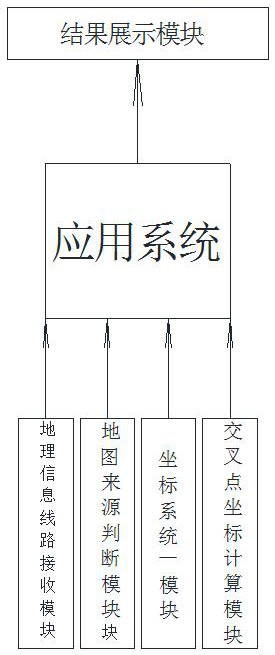
The invention discloses an automatic identification method and system based on geographical information line crossing points, wherein the automatic identification method: according to the coordinate comparison result, determine the coordinate system to be used, and convert and unify the coordinates of the transmission line and the geographic information line , to ensure the accuracy of the calculation of the intersection position, and at the same time mark the calculation results on the map. It solves the disadvantage of low efficiency of manual inspection and recording of intersection locations, that is, the manual recording method is changed to system automatic identification, and the system calculates the intersection coordinates to obtain the intersection location according to the unified line latitude and longitude coordinates. The invention uses machine language to free relevant personnel from complicated work, so as to achieve real-time, efficient and intelligent processing effects.

Description

technical field [0001] The invention relates to the technical field of power system transmission line design, in particular to an automatic identification method and system for line crossover points based on geographical information. Background technique [0002] In the power grid field, the safety of transmission lines is an issue that needs to be paid attention to. During the construction of transmission lines, due to the complex geographical environment of the construction site, the path of transmission lines inevitably intersects with geographical information lines such as roads, railways, bridges, and rivers. When the transmission line is damaged due to high frequency, there are certain potential safety hazards, which need to be paid attention to. At this time, the safety inspection of these intersections can only be carried out by manually recording the intersection positions and regular inspections. This method can be used to a certain extent. To alleviate the potentia...

Claims


Application Information

Patent Timeline
Patent Type & Authority Patents(China)
IPC IPC(8): G06F16/29G06Q50/06
CPCG06F16/29G06Q50/06
Inventor 胡庭彪张宏伟陈跃刘志青卢永强谢荣江颜志坚聂亚兰
Owner 广东信通通信有限公司
Learn More