
Geographic surveying and mapping data information processing method and system based on cloud computing and storage medium

An information processing method and cloud computing technology, applied in the field of geographic surveying and mapping, to improve driving rationality, reduce the incidence of traffic accidents, and avoid driving violations

Inactive Publication Date: 2021-08-27
武汉中科集思地理信息科技有限公司
View PDF0 Cites 0 Cited by
  • Summary
  • Abstract
  • Description
  • Claims
  • Application Information

AI Technical Summary

Problems solved by technology

[0004] In order to at least overcome the above-mentioned deficiencies in the prior art, the object of the present invention is to provide a cloud computing-based geographic surveying and mapping data information processing method, system and storage medium to solve or improve the above-mentioned problems

Method used


Image

  • Geographic surveying and mapping data information processing method and system based on cloud computing and storage medium
  • Geographic surveying and mapping data information processing method and system based on cloud computing and storage medium

Examples


Embodiment Construction

[0049] The following will clearly and completely describe the technical solutions in the embodiments of the present invention with reference to the accompanying drawings in the embodiments of the present invention. Obviously, the described embodiments are only some, not all, embodiments of the present invention. Based on the embodiments of the present invention, all other embodiments obtained by persons of ordinary skill in the art without making creative efforts belong to the protection scope of the present invention.

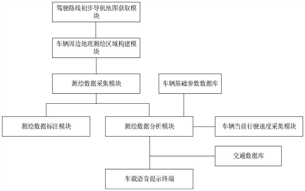
[0050] refer to figure 1 As shown, the first aspect of the present invention proposes a method for processing geographic surveying and mapping data information based on cloud computing, comprising the following steps:

[0051] Step 1. driving route preliminary navigation map acquisition: obtain driving route preliminary navigation map according to vehicle driving starting point and driving end point by driving route preliminary navigation map acquisition modul...


PUM


Abstract

The invention discloses a geographic surveying and mapping data information processing method and system based on cloud computing and a storage medium. The method comprises the steps of constructing a vehicle surrounding geographic surveying and mapping region according to the geographic position of a vehicle, and carrying out the collection of basic road surveying and mapping data, surrounding facility surveying and mapping data and obstacle surveying and mapping data of the vehicle surrounding geographic surveying and mapping region; meanwhile, collecting the current driving speed of the geographic position where the vehicle is located, then comprehensively analyzing various kinds of collected surveying and mapping data and the current driving speed of the vehicle, obtaining corresponding driving instruction prejudgment, carrying out voice prompt on a prejudgment result, and therefore the geographic surveying and mapping data of the driving surrounding environment area are collected and processed. High-precision driving navigation is realized, the driving potential safety hazard is automatically obtained from the geographic surveying and mapping data processing result of the driving surrounding environment area, the targeted driving prejudgment instruction for avoiding the potential safety hazard is generated, a driver can be reminded in time, and the driving safety is greatly guaranteed.

Description

technical field [0001] The invention belongs to the technical field of geographic surveying and mapping, and in particular relates to a cloud computing-based geographic surveying and mapping data information processing method, system and storage medium. Background technique [0002] Geographic surveying and mapping refers to the measurement, collection and drawing of the shape, size, spatial location and attributes of natural geographical elements or surface artificial facilities. With the increasing demand for geographic information service guarantee, the status of geographic surveying and mapping in my country's economic and social development is becoming more and more important. And map surveying and mapping, the application is more and more extensive. [0003] Taking map surveying and mapping here as an example, with the development of network technology, satellite technology and various surveying and mapping technologies, network electronic maps have also emerged as the...

Claims


Application Information

Patent Timeline
IPC IPC(8): G01C15/00B60W50/14
CPCB60W50/14G01C15/00
Inventor 刘善兵
Owner 武汉中科集思地理信息科技有限公司
Learn More