Three-dimensional roadway modeling system and method
A modeling method and 3D model technology, applied in the field of intelligent information, which can solve the problems of inability to meet the rapid visualization of engineering and low efficiency.
- Summary
- Abstract
- Description
- Claims
- Application Information
AI Technical Summary
Problems solved by technology
Method used
Image

Examples
Embodiment 1
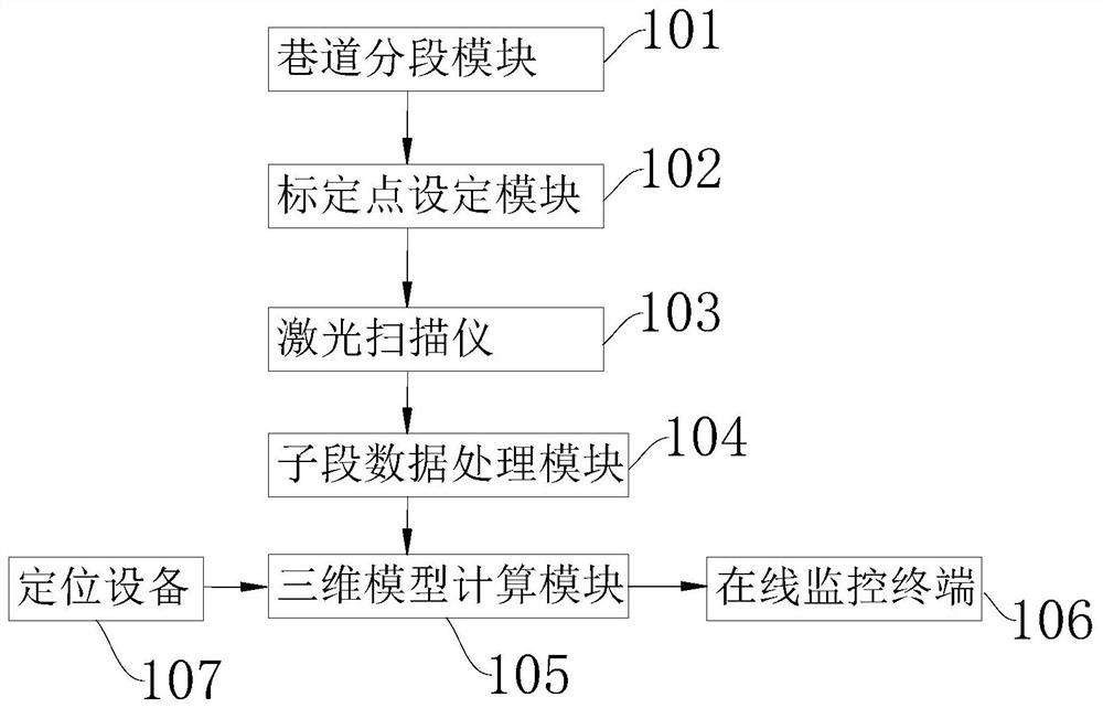
[0034] See figure 1 , figure 1 The schematic of a three-dimensional roadway modeling system provided in the present application embodiment is shown.
[0035] The present application example provides a three-dimensional roadway modeling system, including the roadway segmentation module 101, the calibration point setting module 102, the laser scanner 103, the sub-segment data processing module 104, and the three-dimensional model calculation module 105; the roadshow segmentation module 101 Used to divide the roadway into a plurality of sub-unit segments in accordance with the preset length, and any two adjacent the sub-unit segments are provided with a co-segment; the calibration point setting module 102 is used to set a number of calibration points in the above-mentioned co-section; The laser scanner 103 is configured to obtain a three-dimensional laser scan for any one of the sub-unit segments to obtain three-dimensional point cloud data; the sub-segment data processing module 104...
Embodiment 2
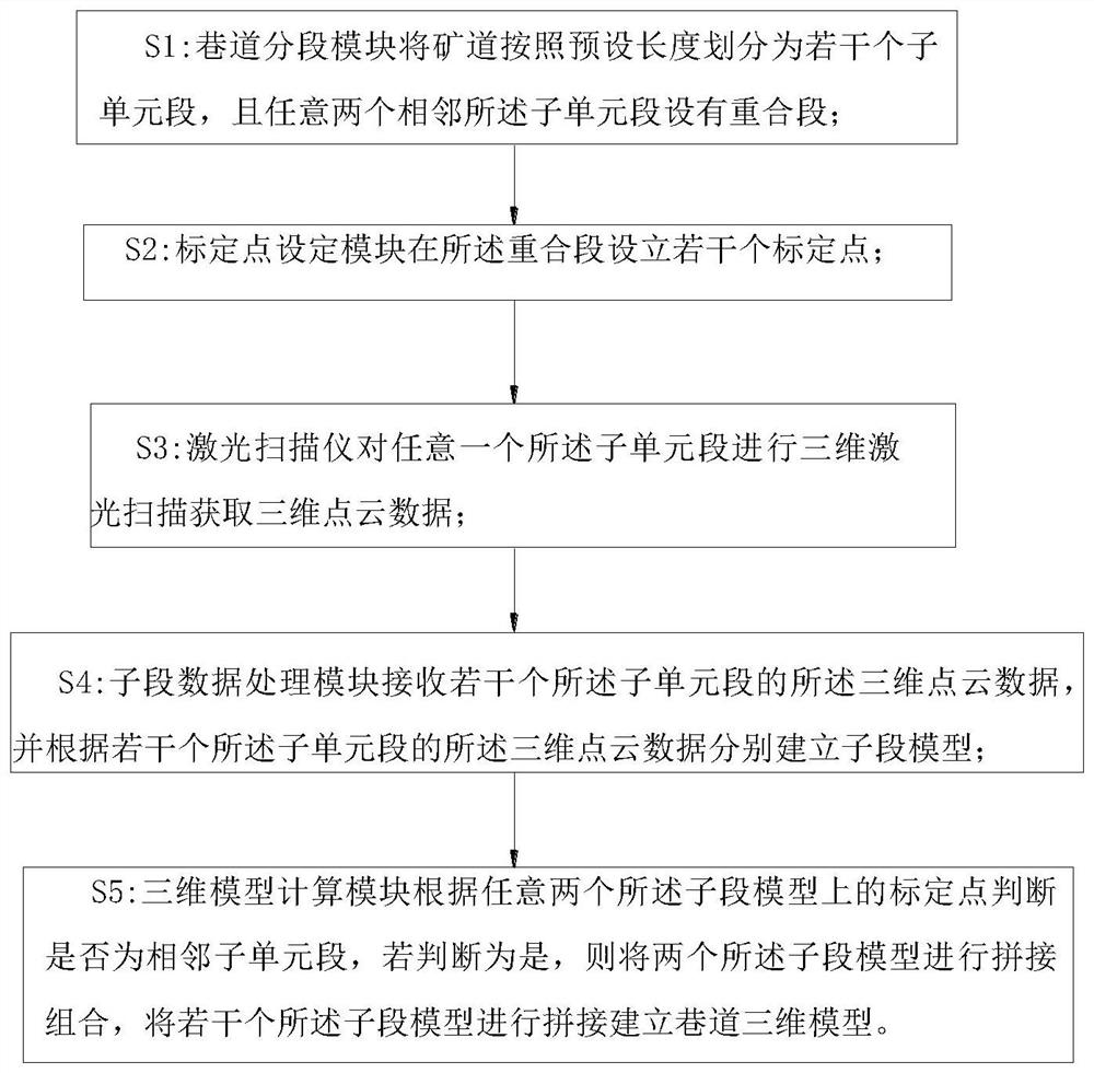
[0044] See figure 2 , figure 2 A flow chart of a three-dimensional road modeling method for the embodiment of the present invention. It includes the following steps: S1: The roadway segmentation module 101 divides the roadway into a plurality of sub-unit segments in accordance with the preset length, and any two adjacent subunit sections are provided with a coincide; S2: The calibration point setting module 102 is in the above Several calibration points are set up; S3: The laser scanner 103 performs three-dimensional laser scan for any one of the sub-unit segments to obtain three-dimensional point cloud data; S4: The sub-segment data processing module 104 receives the three-dimensional point of several of the subunit segments. Cloud data, and established a sub-segment model according to the three-dimensional point cloud data of several of the above sub-unit segments; S5: The three-dimensional model calculation module 105 determines if the calibration point on any two sub-model is ...
Embodiment 3
[0053]The present application embodiment provides an electronic device comprising: a memory for storing one or more programs; a processor; when the above or more programs are performed by the processor, any one of the first embodiment is implemented. Methods.
[0054] The memory, processor, and communication interface are directly or indirectly electrically connected to each other to achieve transmission or interaction of data. For example, these elements can be electrically connected to each other with one or more communication bus or signal lines. The memory can be used to store software programs and modules, such as the program command / module corresponding to the three-dimensional roadway modeling system provided by the present application embodiment, and the processor performs various functional applications and modules to perform software programs and modules stored in memory. data processing. The communication interface can be used to signal signaling or data with other no...
PUM
 Abstract
Description
Claims
Application Information
 - R&D
- Intellectual Property
- Life Sciences
- Materials
- Tech Scout
- Unparalleled Data Quality
- Higher Quality Content
- 60% Fewer Hallucinations
Browse by: Latest US Patents, China's latest patents, Technical Efficacy Thesaurus, Application Domain, Technology Topic, Popular Technical Reports.
© 2025 PatSnap. All rights reserved.Legal|Privacy policy|Modern Slavery Act Transparency Statement|Sitemap|About US| Contact US: help@patsnap.com