Eureka AIR delivers breakthrough ideas for toughest innovation challenges, trusted by R&D personnel around the world.

Navigation mark inspection system and method based on unmanned aerial vehicle remote sensing

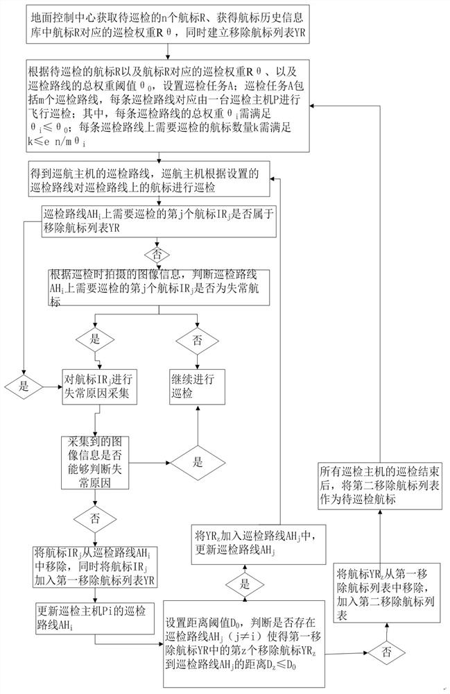
A patrol inspection system and aircraft remote sensing technology, applied in the field of navigation mark inspection, can solve problems such as affecting the service life of drones and prone to failure, and achieve the effect of improving navigation mark maintenance and service quality, increasing work efficiency, and ensuring safe operation.

Active Publication Date: 2021-12-03
TIANJIN TIANYUANHAI TECH DEV LTD CO +1
View PDF10 Cites 1 Cited by
  • Summary
  • Abstract
  • Description
  • Claims
  • Application Information

AI Technical Summary

Problems solved by technology

[0003] In recent years, with the development of large-scale and high-speed ships, higher requirements have been put forward for the advanced nature, accuracy and timeliness of fault recovery. The method of using a single drone for inspection flight is not only time-consuming , and it is prone to failure during the inspection process, which also affects the service life of the UAV, especially in some areas where the waterway is more complicated or the navigation distance is large. If a single UAV is used for cruising, many performance problems may occur Efficiency issues, so in this case, it is often necessary to use multiple drones to carry out inspections in different areas. At this time, how to effectively allocate, how to improve the efficiency of inspections, how to save drone power, and how to improve Requirements such as the service life of UAVs have been put forward by users one after another. At the same time, by planning the inspection routes of multiple UAVs, judging the abnormality of the navigation mark, and obtaining the cause of the abnormality according to the abnormality, when the information obtained is insufficient Problems such as the proper adjustment of the route also appear at the same time, and even on some special position buoys, there are also devices for obtaining information on the buoy itself and the waters around the buoy as the information station of the buoy. To further establish the big data system of the navigation mark, in the process of inspection, it is also necessary to ensure the safe operation of the big data of the navigation mark

Method used


Image

  • Navigation mark inspection system and method based on unmanned aerial vehicle remote sensing
  • Navigation mark inspection system and method based on unmanned aerial vehicle remote sensing
  • Navigation mark inspection system and method based on unmanned aerial vehicle remote sensing

Examples


Embodiment Construction

[0058] The technical solutions in the embodiments of the present application are clearly and completely described below in combination with the drawings in the embodiments of the present application. Obviously, the described embodiments are part of the embodiments of the present application, not all of them. Based on the embodiments in this application, all other embodiments obtained by those skilled in the art without making creative efforts belong to the scope of protection of this application.

[0059] The present application provides an Aids inspection system based on UAV remote sensing, the Aids inspection system includes an Aids to be inspected, a ground control system and an inspection host, wherein the ground control system is used to distribute the Patrol the inspection route of the host, and can judge whether the navigation mark is abnormal through the image information of the navigation mark captured by the inspection host. The navigation mark collects the image of ...


PUM


Abstract

The invention provides a navigation mark inspection system based on unmanned aerial vehicle remote sensing and an inspection method thereof. The navigation mark inspection system comprises a control system, an inspection host and a navigation mark to be inspected, wherein the control system comprises a navigation mark historical information base; the control system further comprises a route distribution module, a navigation mark malfunction judgment module, a malfunction reason collection module and a route adjustment module; the route distribution module is used for distributing an inspection route of the inspection host; the navigation mark malfunction judgment module is used for judging whether the navigation mark is abnormal or not according to the navigation mark information obtained by the inspection host; the malfunction reason collection module is used for acquiring the abnormal information of abnormal navigation marks through the inspection host; the route adjustment module is used for adjusting the inspection route when the abnormal information of the abnormal navigation mark collected by the inspection host cannot judge the abnormal reason, and other inspection hosts are used for collecting the abnormal information of the abnormal navigation mark. The system is advantaged in that inspection efficiency is improved.

Description

technical field [0001] The present application relates to the field of navigational inspection of navigational landmarks, in particular to a navigational inspection system and inspection method of navigational navigational landmarks based on unmanned aerial vehicle remote sensing. Background technique [0002] In recent years, under the background of the continuous development of my country's shipping economy, the number of ports and ships has continued to increase, and accidents at sea and traffic accidents have also occurred from time to time. Therefore, the demand for navigation marks has gradually increased, and the workload of the navigation mark department has increased. , the responsibility for ensuring safety is even greater. Therefore, the maintenance and management of the navigation mark has become the key point. In order to ensure the safety of the route, it is necessary to conduct regular inspections of the navigation mark, so as to grasp and deal with the abnorma...

Claims


Application Information

Patent Timeline
IPC IPC(8): G07C1/20G01D21/02
CPCG07C1/20G01D21/02
Inventor 季克淮霍虎伟毛建峰李铁李金鹏李栋
Owner TIANJIN TIANYUANHAI TECH DEV LTD CO
Why Eureka
Eureka Blog
Learn More