Urban wetland dynamic monitoring method

A dynamic monitoring and wetland technology, applied in the fields of instruments, character and pattern recognition, computer components, etc., can solve the problems of inability to dynamically monitor wetlands, achieve automatic mapping and dynamic monitoring, save time and manpower, and ensure quality and effectiveness. Effect

Pending Publication Date: 2021-12-10
NORTHEAST INST OF GEOGRAPHY & AGRIECOLOGY C A S
View PDF5 Cites 0 Cited by
  • Summary
  • Abstract
  • Description
  • Claims
  • Application Information

AI Technical Summary

Problems solved by technology

[0003] Aiming at the problem that the existing remote sensing technology cannot quickly and accurately monitor wetlands within the city, the present invention provides a dynamic monitoring method for urban wetlands

Method used


Image

  • Urban wetland dynamic monitoring method
  • Urban wetland dynamic monitoring method
  • Urban wetland dynamic monitoring method

Examples


specific Embodiment

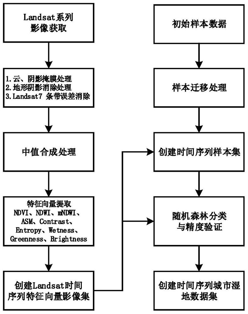
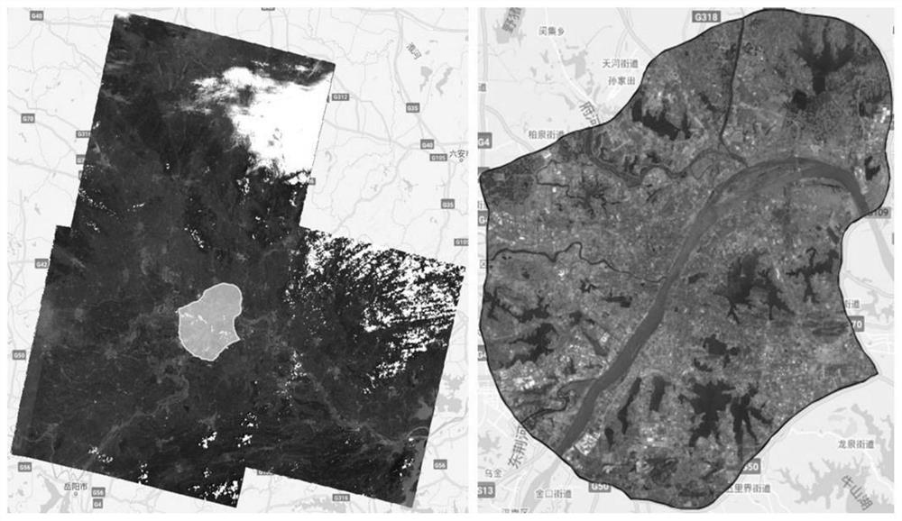
[0057] (1) image 3 Indicates the process of image acquisition and preprocessing. The test is carried out in a certain urban area. Taking the image of a certain urban area in 2020 as an example, the yellow area in the left picture is a certain urban area. According to the area of ​​a certain urban area, 18 Landsat8 remote sensing images of various periods were retrieved. After cloud mask processing, Terrain shadow elimination processing and image median synthesis to obtain 2020 high-quality Landsat remote sensing images of an urban area (R:C:B=band 4:3:2);

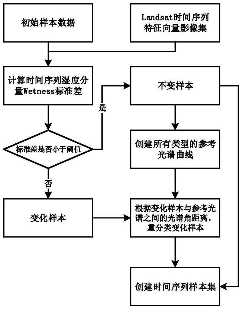
[0058] (2) Figure 4 Indicates the feature vector extraction process. Based on the processed Landsat image of an urban area, the feature vector of the image is calculated, including: normalized normalized vegetation index NDVI, normalized normalized water index NDWI, improved normalized normalized water index mNDWI, second-order Moment ASM, contrast Contrast, information entropy Entropy, humidity component Wetness, green...


PUM


Abstract

The invention provides an urban wetland dynamic monitoring method, belongs to the technical field of remote sensing extraction, and solves the problem that the existing remote sensing technology cannot rapidly and accurately carry out dynamic monitoring on wetlands in an urban range, the method comprises the following steps: based on a global scale remote sensing cloud computing platform, obtaining Landsat series images, preprocessing the obtained images, and establishing a time sequence image set according to the preprocessed images; acquiring feature vectors of the images, and establishing a time sequence feature vector image set; carrying out sample migration on the time sequence images through a time sequence image analysis and decision tree model to obtain a time sequence sample set suitable for each image; based on the time sequence feature vector data set and the time sequence sample set, performing year-by-year urban wetland extraction, and establishing a time sequence urban wetland data set; and carrying out overlay analysis on the time sequence urban wetland data set, analyzing the dynamic change of the urban wetland range in the time sequence, and realizing dynamic change monitoring on the urban wetland.

Description

technical field [0001] The invention relates to the technical field of remote sensing extraction and dynamic monitoring of urban wetlands, in particular to a method for dynamic monitoring of urban wetlands based on time series Landsat satellite images and a cloud computing platform. Background technique [0002] Urban wetlands provide a range of valuable ecosystem services and have enormous economic and social value. However, with increasing population and rapid economic development, the loss, degradation, and related environmental disasters of urban wetlands have accelerated over the past three decades. With significant advances in remote sensing technology and an increasing number of available data sources, a large number of meaningful studies have been conducted using remote sensing technology on wetlands at national and regional scales, including mangroves, aquaculture ponds, tidal flats and salt marshes, etc., however, There are relatively few studies on rapid mapping ...

Claims


Application Information

Patent Timeline
Patent Type & Authority Applications(China)
IPC IPC(8): G06K9/00G06K9/62
CPCG06F18/24323
Inventor 王铭毛德华宋开山
Owner NORTHEAST INST OF GEOGRAPHY & AGRIECOLOGY C A S
Why Eureka
Try Eureka