
Development intensity evaluation method, device and equipment for land planning

A planning and strength technology, applied in design optimization/simulation, special data processing applications, instruments, etc., to achieve the effect of improving efficiency

Active Publication Date: 2021-12-28
GUANGZHOU URBAN PLANNING & DESIGN SURVEY RES INST
View PDF5 Cites 1 Cited by
  • Summary
  • Abstract
  • Description
  • Claims
  • Application Information

AI Technical Summary

Problems solved by technology

[0006] Various aspects of the present invention provide a method, device, and equipment for evaluating the development intensity of planned land to solve the technical problems of the above-mentioned defects in the existing evaluation methods of planned land development. The present invention can conveniently, quickly and intuitively evaluate the plot ratio of land Quantitative matching relationship with road network planning indicators, thereby improving the efficiency of traffic impact assessment

Method used


Image

  • Development intensity evaluation method, device and equipment for land planning
  • Development intensity evaluation method, device and equipment for land planning
  • Development intensity evaluation method, device and equipment for land planning

Examples


Embodiment Construction

[0066] The following will clearly and completely describe the technical solutions in the embodiments of the present invention with reference to the accompanying drawings in the embodiments of the present invention. Obviously, the described embodiments are only some, not all, embodiments of the present invention. Based on the embodiments of the present invention, all other embodiments obtained by persons of ordinary skill in the art without creative efforts fall within the protection scope of the present invention.

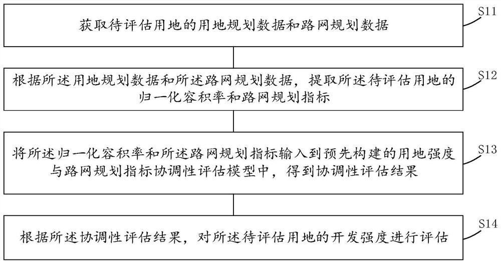
[0067] see figure 1 , figure 1 It is a schematic flowchart of an embodiment of the method for assessing the development intensity of planned land provided by the present invention.

[0068] The method for evaluating the development intensity of planned land provided by the embodiment of the present invention includes steps S11 to S14:

[0069] Step S11, obtaining land use planning data and road network planning data of the land to be evaluated;

[0070] Step S12...


PUM


Abstract

The invention discloses a development intensity evaluation method, device and equipment for land planning. The evaluation method comprises the following steps: acquiring land planning data and road network planning data of a land to be evaluated; extracting a normalized plot ratio and a road network planning index of the land to be evaluated according to the land planning data and the road network planning data; inputting the normalized plot ratio and the road network planning index into a pre-constructed land intensity and road network planning index coordination evaluation model to obtain a coordination evaluation result; and according to the coordination evaluation result, evaluating the development intensity of the land to be evaluated, and by establishing a land intensity and road network planning index coordination evaluation model, rapidly and intuitively evaluating the quantitative matching relation between the planned land plot ratio and the road network index. And rationality and working efficiency of land development intensity in planning compilation of types such as detailed planning and city updating are improved.

Description

technical field [0001] The invention relates to the technical field of urban and rural planning, in particular to a method, device and equipment for evaluating the development intensity of planned land. Background technique [0002] FAR is the core indicator of land use planning, which determines the scale of development of construction land, and has an important impact on the development of land value, the shaping of urban space, and road traffic operation. Its value is widely used in urban and rural planning and design, transportation planning Design, project development and construction and many other areas of concern. Since an excessively high land use volume ratio will lead to a series of "urban diseases" that reduce the living environment such as overpopulation and traffic congestion, all localities are extremely cautious about the value of the planned volume ratio of construction land. For this reason, traffic impact assessment projects for detailed planning, urban r...

Claims


Application Information

Patent Timeline
Patent Type & Authority Applications(China)
IPC IPC(8): G06F30/20G06F119/02
CPCG06F30/20G06F2119/02Y02A30/60
Inventor 狄德仕曾滢张晓明周茂松吕连恩
Owner GUANGZHOU URBAN PLANNING & DESIGN SURVEY RES INST
Learn More