Extraterrestrial unknown environment beyond visual range global path planning system and method

A global path planning and unknown environment technology, applied in the field of mobile detector/robot path planning system, can solve the problem that the target point of path planning is beyond the effective line of sight, the global path planning cannot be performed, and the range of restored terrain is limited. Achieve good results, easy to implement, high accuracy

Pending Publication Date: 2021-12-31
BEIJING INST OF CONTROL ENG
View PDF8 Cites 5 Cited by
  • Summary
  • Abstract
  • Description
  • Claims
  • Application Information

AI Technical Summary

Problems solved by technology

Since there is no high-resolution map known in advance for extraterrestrial exploration, the range of terrain that can be recovered by the sensing sensor carried by the probe itself is limited. For example, the error of the independent three-dimensi...

Method used


Image

  • Extraterrestrial unknown environment beyond visual range global path planning system and method
  • Extraterrestrial unknown environment beyond visual range global path planning system and method
  • Extraterrestrial unknown environment beyond visual range global path planning system and method

Examples


Embodiment 1

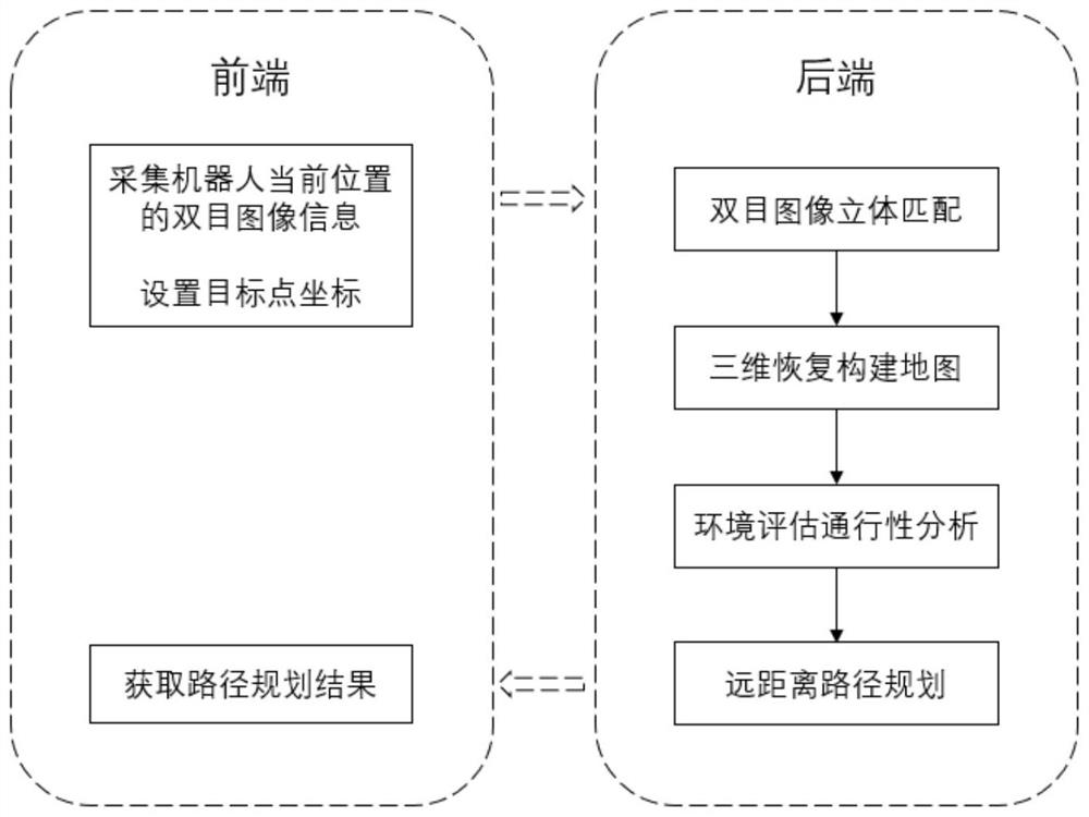
[0084] The invention provides a long-distance path planning system and method for a robot in an unknown environment.

[0085] refer to figure 1 , figure 1 It is a schematic flowchart of an embodiment of the robot path planning method of the present invention. In this embodiment, the path planning method of the robot includes:

[0086] (1) The front-end module acquires binocular image information;

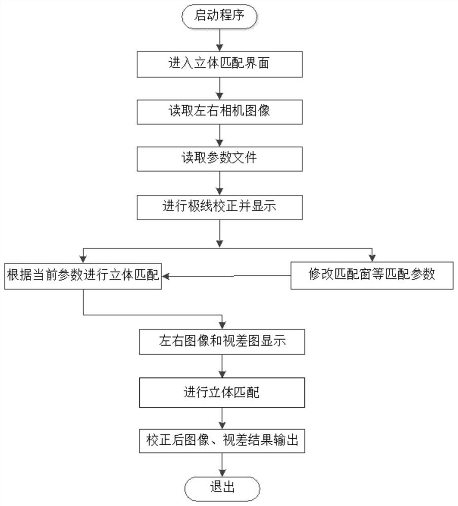
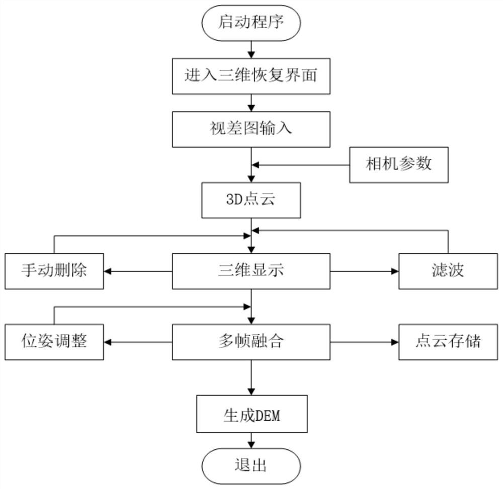
[0087] (2) The back-end module performs stereo matching on binocular images, and the specific steps are: perform epipolar correction and matching on binocular image pairs, and extract disparity information; refer to figure 2 Specifically, the stereo matching step of the binocular image includes: selecting a camera parameter file, which includes epipolar correction parameters and stereo matching parameters; performing epipolar correction according to the read-in binocular image and camera parameters; The disparity data is filtered to generate a disparity map; the result of the d...


PUM


Abstract

The invention discloses an extraterrestrial unknown environment beyond visual range global path planning method. The method is characterized in that the beyond visual range path planning is carried out based on a regional global grid map and a passing cost weight, a passing cost function is introduced to search on the global grid map to obtain an optimal path, and finally, the path points of a visible region are output. A good effect is achieved in the large-range global path planning, and an extraterrestrial mobile detector/robot can be supported to realize efficient mobile detection. The invention further discloses an extraterrestrial unknown environment beyond-visual-range global path planning system, and the extraterrestrial unknown environment beyond-visual-range global path planning method is achieved through the cooperation of a front-end module and a rear-end module.

Description

technical field [0001] The invention relates to the field of computer technology, in particular to a path planning system and method for a mobile detector / robot. Background technique [0002] Path planning is an essential function for safe and efficient movement of mobile robots. The existing ground / extraterrestrial mobile detector / robot path planning algorithms are all based on path planning with known environmental information. In areas where environmental information is unknown, path planning cannot be performed due to lack of terrain information. [0003] In the future manned moon landing and Mars exploration missions, the detection range and moving speed will be significantly improved, and it is necessary to solve the problem of large-scale path planning with targets at a distance of 100 meters or more. Since there is no high-resolution map known in advance for extraterrestrial exploration, the range of terrain that can be recovered by the sensing sensor carried by the...

Claims


Application Information

Patent Timeline
IPC IPC(8): G05D1/02
CPCG05D1/0251G05D1/0214G05D1/0221G05D1/0276
Inventor 邢琰段文杰孙赫捷滕宝毅毛晓艳周益杨力贾永
Owner BEIJING INST OF CONTROL ENG
Why Eureka
Try Eureka