Detection system and method for determining spatial position information of underground deeply-buried pipeline

A technology of spatial location information and detection system, which is applied in the field of detection systems for quickly determining the spatial location information of underground deep buried pipelines, can solve the problems of inability to detect the spatial location information of deep buried pipelines, limited ground detection depth, and huge influence, etc. Achieve accurate and reliable detection results, simple and practical detection methods, and overcome the effects of small detection depths

Active Publication Date: 2022-01-07
CHINA RAILWAY LIUYUAN GRP CO LTD
View PDF5 Cites 0 Cited by
  • Summary
  • Abstract
  • Description
  • Claims
  • Application Information

AI Technical Summary

Problems solved by technology

At present, the existing pipeline detectors are all based on the principle of frequency domain electromagnetic method to detect metal pipelines, which are greatly affected by the resistivity of the formation medium. In areas with low formation resistivity, the general ground detection depth range is only about 5 meters, which cannot be detected. Spatial location information of deeply buried pipelines at a deeper range; for non-metallic pipelines, the ground detection depth is more limited
However, when the exact location of such pipelines is uncertain, it will have a huge impact on the construction of other underground crossing projects or the utilization and development of underground space

Method used


Image

  • Detection system and method for determining spatial position information of underground deeply-buried pipeline
  • Detection system and method for determining spatial position information of underground deeply-buried pipeline
  • Detection system and method for determining spatial position information of underground deeply-buried pipeline

Examples


Embodiment 1

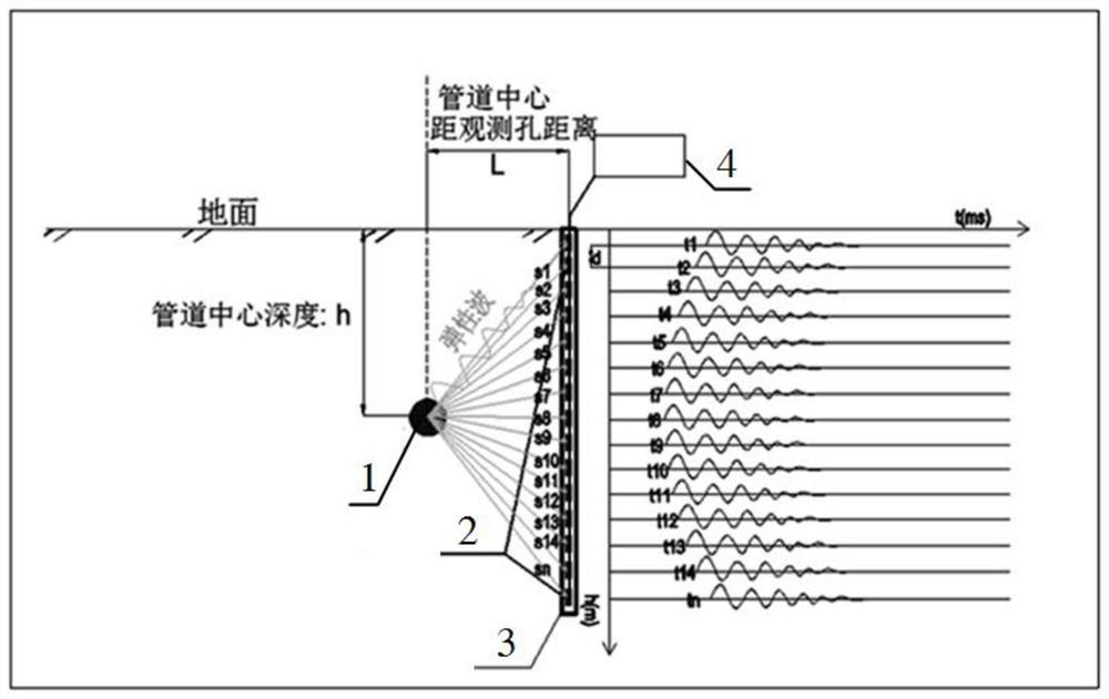
[0035] Embodiment 1: as Figures 1 to 3 As shown, a detection system for determining the spatial position information of an underground deep-buried pipeline includes a vibroseis, a geophone array, an observation hole 3 and a multi-channel seismometer 4; wherein:

[0036] The vibrator is an artificial vibrator or a mechanical vibrator, which is used to excite elastic wave signals on the deep buried pipeline 1;

[0037] The geophone array is composed of several geophones 2 connected in series for receiving elastic wave signals, and the several geophones arranged in series are arranged equidistantly in the observation hole 3, and the observation hole 3 is vertical to the ground It is buried in the range of 2-5m beside the far end of the estimated deep buried pipeline;

[0038] The multi-channel seismograph 4 is respectively connected with each geophone 2 arranged in the observation hole 3, and is used for recording the elastic wave signal collected by the corresponding geophone....

Embodiment 2

[0040] Embodiment 2: as Figures 1 to 4 As shown, a method for detecting the spatial position information of underground deep-buried pipelines based on the detection system described in embodiment 1 specifically includes the following steps:

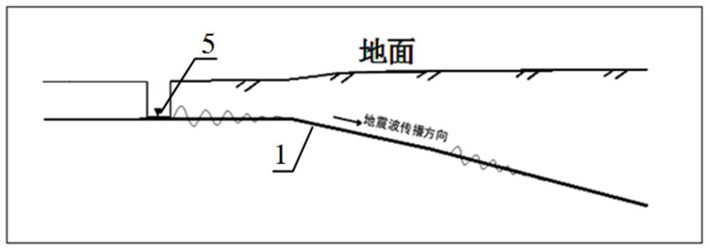
[0041] Such as figure 1 As shown in: S1, determine the appropriate excitation point 5, and use the artificial or mechanical source to excite the elastic wave signal on the deep-buried pipeline 1; wherein: the excitation point 5 is set in the inspection well near the deep-buried pipeline 1; There is no inspection well around the pipeline 1, and a deep pit is excavated to expose the outer wall of the pipeline for direct excitation;

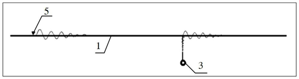
[0042] Such as figure 2 As shown: S2, the observation hole 3 is arranged within the range of 2-5m beside the far end of the estimated deep buried pipeline 1;

[0043]Such as image 3 As shown in: S3, put several geophones 2 equidistantly arranged in the observation hole 3, and connect several geophones 2 ...


PUM


Abstract

The invention relates to a detection system and method for determining spatial position information of an underground deeply-buried pipeline. The detection system utilizes an artificial seismic source or a mechanical seismic source to excite an elastic wave signal to the deeply-buried pipeline; an observation hole is formed in the range of 2-5 m beside the far end of the estimated deeply-buried pipeline; a plurality of detectors which are arranged at equal intervals are placed in the observation holes, and the plurality of detectors are connected with corresponding seismographs respectively. According to the detection method, an in-hole detector is adopted to receive an elastic wave signal from a target pipeline, the first arrival time of the detector signal is analyzed through a multi-channel seismograph, the burying depth of the pipeline and the distance between the pipeline and an observation hole are calculated, and then the spatial position of the deeply-buried pipeline is determined. The method can be suitable for spatial position detection of underground metal pipelines and nonmetal pipelines with various burying depths, the detection means is simple and practical, the detection result is accurate and reliable, and no damage is caused to the target pipeline.

Description

technical field [0001] The invention relates to the field of underground pipeline detection, in particular to a detection system and method capable of rapidly determining spatial position information of underground deep-buried pipelines, and the method is applicable to metal pipelines and non-metal pipelines. Background technique [0002] With the development of the city, the laying of underground pipelines is becoming more and more dense. Due to the limitation of underground space, most of the newly laid underground pipelines adopt non-excavation construction when crossing roads, especially when crossing buildings, rivers and other areas, the depth of pipelines can reach 20-40 Meter. At present, the existing pipeline detectors are all based on the principle of frequency domain electromagnetic method to detect metal pipelines, which are greatly affected by the resistivity of the formation medium. In areas with low formation resistivity, the general ground detection depth ran...

Claims


Application Information

Patent Timeline
Patent Type & Authority Applications(China)
IPC IPC(8): G01V1/00G01V1/20G01V1/28
CPCG01V1/00G01V1/20G01V1/28Y02A90/30
Inventor 裴世建于强闫高翔刘黎东李耐宾章飞亮雷凯
Owner CHINA RAILWAY LIUYUAN GRP CO LTD
Why Eureka
Try Eureka