Ship position and speed deviation correction method, device and system

A speed deviation and ship technology, which is applied in the field of ship position and speed deviation correction, can solve problems such as false alarms, missed alarms in submarine cable monitoring systems, and large error ranges of radar signal positions, so as to reduce errors and solve missed alarms or false alarms. The effect of the alarm

Pending Publication Date: 2022-01-14
杭州晟冠科技有限公司
View PDF0 Cites 0 Cited by
  • Summary
  • Abstract
  • Description
  • Claims
  • Application Information

AI Technical Summary

Problems solved by technology

[0003] The present disclosure provides a ship position and speed deviation correction method, device and system, aiming at solving the problem of large position error range and large ship speed error range of the ship to be positioned obtained by the shore-based radar system in the prior art, which is easy to solve. Problems that lead to missed alarms or false alarms in the submarine cable monitoring system

Method used


Image

  • Ship position and speed deviation correction method, device and system
  • Ship position and speed deviation correction method, device and system
  • Ship position and speed deviation correction method, device and system

Examples


Embodiment 1

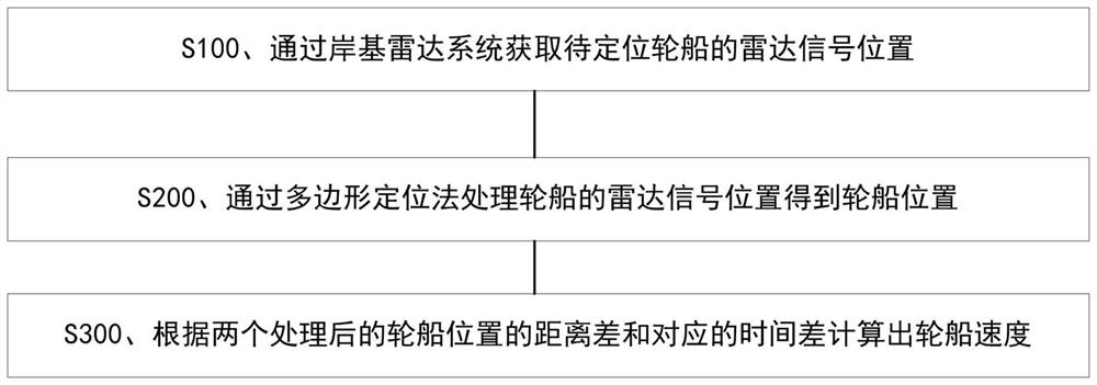
[0051] Such as figure 1 As shown, the ship position and speed deviation correction method includes the following steps:

[0052] S100. Obtain the radar signal position of the ship to be positioned through the shore-based radar system;

[0053] S200. Process the radar signal position of the ship through the polygon positioning method to obtain the position of the ship;

[0054] S300. Calculate the speed of the ship according to the distance difference between the two processed ship positions and the corresponding time difference.

[0055] Among them, the shore-based radar system refers to a radar system installed at a fixed location such as an ocean coast or an island.

[0056] Wherein, the radar signal position refers to the signal position of the ship acquired by the shore-based radar system, and there is a certain error between the position and the actual ship position.

[0057] Among them, the polygon positioning method refers to marking the positions of multiple radar s...

Embodiment 2

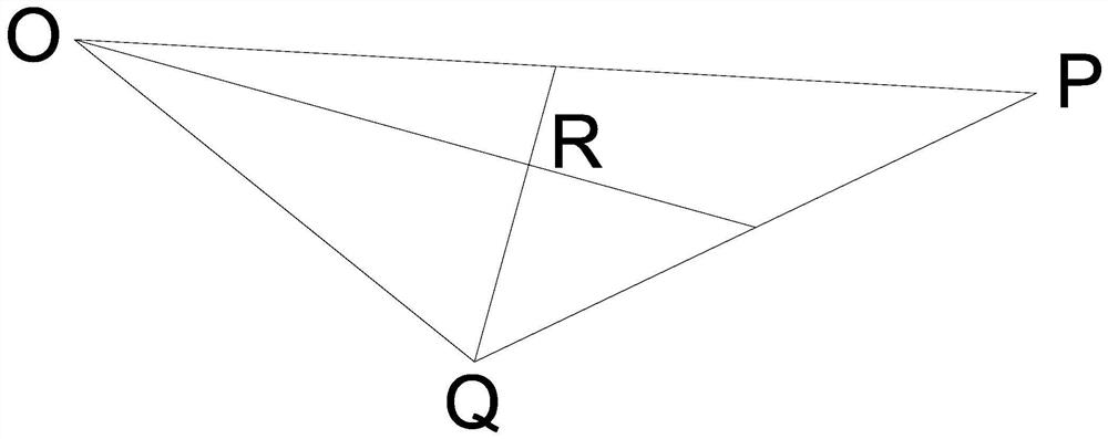
[0063] On the basis of Embodiment 1, the present embodiment provides two implementation schemes for obtaining the position of the ship by processing the radar signal position of the ship through the polygon positioning method, and one of the two implementation schemes can be selected arbitrarily, as follows:

no. 1 approach

[0064] In the first embodiment, the obtaining the position of the ship by processing the radar signal position of the ship through the polygon positioning method comprises the following steps:

[0065] S201. Form four radar signal positions on the plane according to the radar signal positions of the ship reported four times in a row, and connect the four radar signal positions to form a quadrilateral;

[0066] S202. Connect the diagonals of the quadrilaterals to obtain a first intersection point, and the first intersection point is used as the position of the ship.

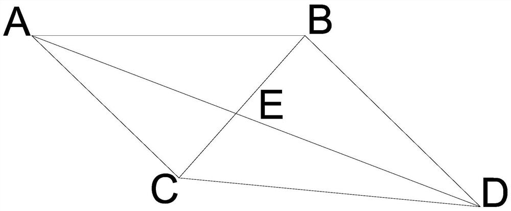
[0067] Combine below figure 2 The first embodiment of the polygon positioning method is further illustrated:

[0068] According to the radar signal position of the ship reported four times consecutively by the radar, four radar signal positions are formed on the plane, which are marked as four points A, B, C, and D respectively, and four points A, B, C, and D are connected to form A quadrilateral M; connect the...


PUM


Abstract

The invention provides a ship position and speed deviation correction method, a device and a system, and the method comprises the steps: obtaining a radar signal position of a to-be-positioned ship through a shore-based radar system; processing the radar signal position of the ship through a polygon positioning method to obtain the position of the ship; and calculating the speed of the ship according to the distance difference between the two processed positions of the ship and the corresponding time difference. The ship position and speed deviation correction system comprises a shore-based radar system, a ship position calculation unit and a speed calculation unit. According to the invention, after the radar signal position of the ship is processed by adopting the polygon positioning method, the error of the position of the ship to be tracked is reduced, and the problem that the error range of the calculated ship speed is large due to the large error range of the position of the ship is solved. By adopting the technical scheme disclosed by the invention in a submarine cable monitoring system, the problem of missed alarm or false alarm caused by large position and speed error range of a ship is effectively solved.

Description

technical field [0001] The disclosure belongs to the technical field of ship positioning, and in particular relates to a method, device and system for correcting ship position and speed deviations. Background technique [0002] The submarine cable monitoring system determines the position of the ship through technical means such as the ship's AIS signal, radar signal and video signal, and at the same time combines the ship's course and speed and the scope of the protection zone of the submarine cable to give an alarm and early warning to the ship. Since not every ship sailing on the sea can correctly send out AIS signals (for example, the owner deliberately unplugs the AIS power supply, the equipment is damaged, etc.), so it is extremely important to locate the position of the ship through the radar system. The shore-based radar of general submarine cable monitoring scans a circle in 2 seconds to 5 seconds. After scanning, the position of the ship is updated, and the positio...

Claims


Application Information

Patent Timeline
Patent Type & Authority Applications(China)
IPC IPC(8): G01S13/91G01S13/92
CPCG01S13/917G01S13/92
Inventor 傅超二曹光客田少华杜礼会李学李旭程士军
Owner 杭州晟冠科技有限公司
Why Eureka
Try Eureka