BIM and Vissim fused construction traffic organization three-dimensional analogue simulation method

A technology of three-dimensional simulation and simulation method, applied in 3D modeling, image data processing, special data processing applications, etc., to achieve the effects of ensuring non-interference, optimizing evaluation and guidance, and improving feasibility and efficiency

Pending Publication Date: 2022-02-01
SHANDONG HI SPEED GRP CO LTD +2
View PDF0 Cites 3 Cited by
  • Summary
  • Abstract
  • Description
  • Claims
  • Application Information

AI Technical Summary

Problems solved by technology

[0004] The purpose of the present invention is to provide a three-dimensional simulation method of construction traf

Method used


Image

  • BIM and Vissim fused construction traffic organization three-dimensional analogue simulation method
  • BIM and Vissim fused construction traffic organization three-dimensional analogue simulation method
  • BIM and Vissim fused construction traffic organization three-dimensional analogue simulation method

Examples


Embodiment 1

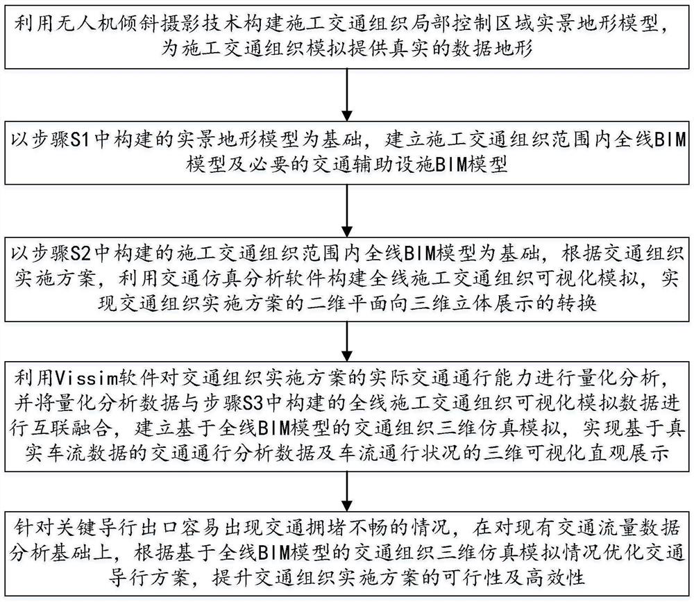
[0048] Such as figure 1 As shown, this embodiment provides a three-dimensional simulation method for construction traffic organization that integrates BIM and Vissim, including the following steps,

[0049] S1. Use UAV oblique photography technology to build a real terrain model of the local control area of ​​the construction traffic organization, providing real data terrain for the simulation of the construction traffic organization;

[0050] S2. Based on the real terrain model constructed in step S1, establish the BIM model of the whole line within the scope of construction traffic organization and the BIM model of necessary traffic auxiliary facilities;

[0051] S3. Based on the BIM model of the whole line within the scope of the construction traffic organization constructed in step S2, according to the traffic organization implementation plan, use traffic simulation analysis software to construct a visual simulation of the entire construction traffic organization, and real...

Embodiment 2

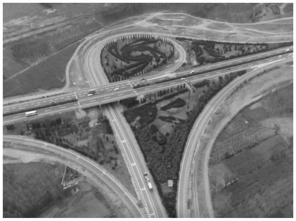
[0094] In this embodiment, taking Luozhuang Intercommunication as an example, the implementation process of the method of the present invention is described in detail.

[0095] As a key control project in the reconstruction and expansion of the Beijing-Shanghai Expressway, the Luozhuang Interchange has a wide coverage, involves a large number of ramps in the reconstruction and expansion, and the construction traffic organization is relatively large. achievement of goals. ,Such as figure 2 As shown, the terrain of the entire aerial survey area is flat, the east-west length is about 400m, the north-south length is about 600m, approximately rectangular, with an area of ​​about 0.25km 2 .

[0096] In this embodiment, the fixed-wing UAV is used to carry the autonomous platform to obtain the original image data of the aerial photography area, and the POS data corresponding to the image is obtained according to the UAV navigation GPS / IMU positioning and orientation system and the ...


PUM


Abstract

The invention discloses a BIM and Vissim fused construction traffic organization three-dimensional analogue simulation method, wherein the method comprises the steps: constructing a construction traffic organization local control area live-action terrain model by utilizing an unmanned aerial vehicle oblique photography technology, and providing a real data terrain for construction traffic organization simulation; on the basis of the constructed live-action terrain model, establishing a whole-line BIM model and a necessary traffic auxiliary facility BIM model within a construction traffic organization range; and on the basis of the whole-line BIM model within the construction traffic organization range, constructing whole-line construction traffic organization visual simulation by using traffic simulation analysis software according to the traffic organization implementation scheme, and realizing conversion from a two-dimensional plane to a three-dimensional display of the traffic organization implementation scheme and the like. The method has the advantages that interconnection and intercommunication of traffic organization three-dimensional simulation software and Vissim traffic analysis data are achieved, meanwhile, real traffic flow data of the expressway are associated, and the real traffic condition under the traffic organization scheme implementation condition is highly restored.

Description

technical field [0001] The invention relates to the technical field of construction traffic organization simulation simulation, in particular to a three-dimensional simulation method for construction traffic organization integrated with BIM and Vissim. Background technique [0002] Three-dimensional intersection simulation technology is to use BIM technology to carry out three-dimensional visual simulation of traffic organization implementation plan, realize the transformation of intersection plan from two-dimensional plane to three-dimensional display, and use it for visual guidance and optimization of traffic organization design and implementation, which can greatly improve The operability of the implementation of traffic organization meets the technical requirements of "guaranteeing traffic" and "guaranteeing safety". [0003] During the construction of highway interchanges and reconstruction and expansion projects, it is necessary to take into account the normal traffic ...

Claims


Application Information

Patent Timeline
IPC IPC(8): G06F30/13G06T17/05
CPCG06F30/13G06T17/05G06T2210/04
Inventor 周磊生董鹏迟朝明闫昕胡超张轩瑜张艳王泽飞田垚
Owner SHANDONG HI SPEED GRP CO LTD
Why Eureka
Try Eureka