Airborne SAR image control-point-free real-time positioning method suitable for complex terrain

A no-control point, real-time positioning technology, applied in image analysis, image data processing, geographic information database, etc., to achieve the effect of avoiding calculation failure, reducing positioning error, and avoiding the impact of positioning accuracy

Active Publication Date: 2022-02-08
AEROSPACE INFORMATION RES INST CAS
View PDF3 Cites 2 Cited by
  • Summary
  • Abstract
  • Description
  • Claims
  • Application Information

AI Technical Summary

Problems solved by technology

[0009] The purpose of the invention is to solve the problem of real-time high-precision positioning of UAV-borne SAR images with complex terrain in plateau mountainous areas
The present invention aims at the SAR image data stream downloaded in real time by the UAV communication link, and solves the following problems: (1) perform target geographic positioning in the process of image real-time display; precision target positioning

Method used


Image

  • Airborne SAR image control-point-free real-time positioning method suitable for complex terrain
  • Airborne SAR image control-point-free real-time positioning method suitable for complex terrain
  • Airborne SAR image control-point-free real-time positioning method suitable for complex terrain

Examples


Embodiment Construction

[0027] In order to make the purpose, technical solution and advantages of the present invention clearer, the technical solution of the present invention will be further described in detail below in conjunction with the accompanying drawings and embodiments.

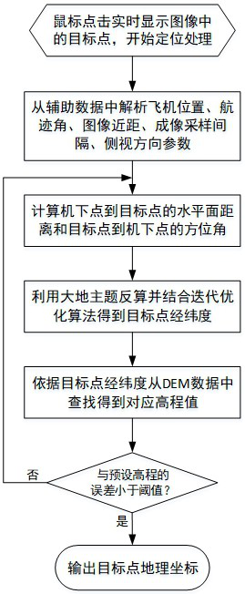
[0028] According to one embodiment of the present invention, a method for real-time positioning of airborne SAR images without control points adapted to complex terrain is proposed, such as figure 1 shown, including the following steps:

[0029] Step 1. Calculate the memory address corresponding to the target center through the mouse click position, and obtain the SAR auxiliary data corresponding to the target through the memory address;

[0030] Step 2, analyzing the aircraft position, imaging track angle, image close range, image sampling interval, and side-view direction parameters from the SAR auxiliary data; the aircraft position includes longitude, latitude, and height;

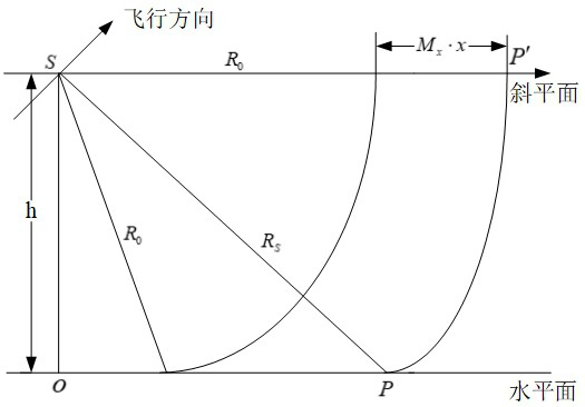
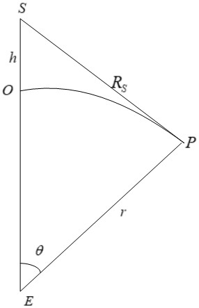
[0031] Step 3. Calculate the distance from ...


PUM


Abstract

The invention relates to an airborne synthetic aperture radar (SAR) image control-point-free real-time positioning method suitable for complex terrains, which comprises the following steps of: 1, calculating a memory address corresponding to a target center through a mouse click position, and acquiring SAR auxiliary data corresponding to a target through the memory address; 2, analyzing aircraft position, imaging track angle, image close range, image sampling interval and side view direction parameters from the SAR auxiliary data; the airplane position comprising longitude, latitude and height; 3, geometrically calculating the distance from the target to the point under the aircraft by using SAR imaging according to the image sampling interval, the image short distance, the aircraft height and the imaging area elevation parameters; 4, calculating the azimuth angle of the target relative to the off-machine point; 5, obtaining the latitude and longitude of a target point by using a geodetic topic positive calculation formula and an iterative optimization algorithm according to the known latitude and longitude of a point under a machine, the distance from the target to the point under the machine and the azimuth angle of the target relative to the point under the machine; and 6, based on DEM data, carrying out iterative solution to obtain a final longitude and latitude value of the target point.

Description

technical field [0001] The invention relates to the technical field of airborne Synthetic Aperture Radar (SAR) image positioning, in particular to a real-time geographic positioning method for UAV-borne SAR images without control points for complex terrain in plateau areas. The present invention can perform high-precision geographic positioning without control points on the SAR image data downloaded in real time by the communication link of the UAV, and the method described in the present invention is also applicable to manned airborne SAR. Background technique [0002] The UAV aerial remote sensing platform has the characteristics of long battery life, real-time image transmission, detection of high-risk areas, low cost, and strong mobility. Therefore, it has become a powerful supplement to satellite remote sensing and manned aerial remote sensing. Synthetic Aperture Radar (SAR) has the characteristics of all-weather and all-weather work, and has good detection and resoluti...

Claims


Application Information

Patent Timeline
Patent Type & Authority Applications(China)
IPC IPC(8): G06T7/70G06F16/9537G06F16/29G01S13/90
CPCG06T7/70G01S13/9021G06F16/9537G06F16/29
Inventor 潘志刚刘畅徐向辉李志勇王小龙董旭彬
Owner AEROSPACE INFORMATION RES INST CAS
Why Eureka
Try Eureka