Land cover data fusion correction method

A data fusion and overlay technology, applied in the fields of instruments, character and pattern recognition, computer parts, etc., can solve the problems of coarse resolution and large mixed pixels, and achieve the improvement of efficiency, resolution and accuracy, with The effect of portability

Active Publication Date: 2022-02-15
INST OF GEOGRAPHICAL SCI & NATURAL RESOURCE RES CAS
View PDF10 Cites 4 Cited by
  • Summary
  • Abstract
  • Description
  • Claims
  • Application Information

AI Technical Summary

Problems solved by technology

[0004] The technical problem to be solved by the present invention is to provide a super-resolution land cover data fusion correction method to solve the technical problems of the existing multi-source data fusion process that the resolution of the result is too coarse and there are a large number of mixed pixels. one or more

Method used


Image

  • Land cover data fusion correction method
  • Land cover data fusion correction method
  • Land cover data fusion correction method

Examples


Embodiment 1

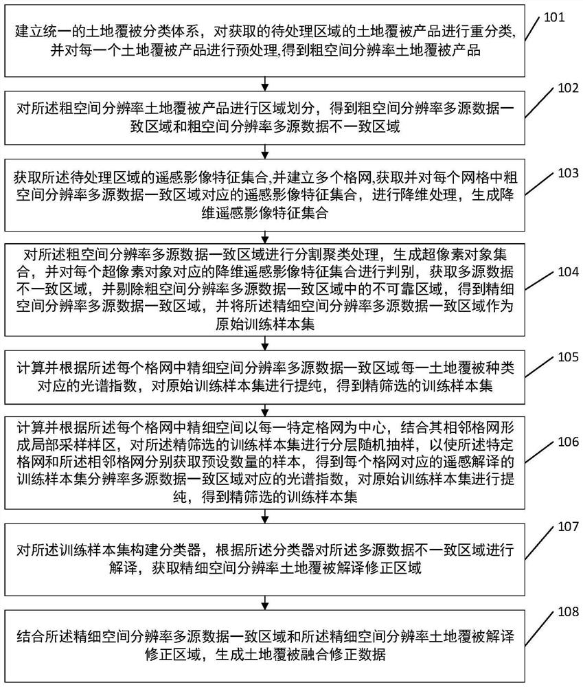
[0054] see figure 1 , figure 1 It is a schematic flow chart of an embodiment of a land cover data fusion correction method provided by the present invention, as figure 1 As shown, the method includes step 101-step 108, specifically as follows:

[0055] Step 101: Establish a unified land cover classification system, reclassify the obtained land cover products in the area to be processed, and preprocess each land cover product to obtain a coarse spatial resolution land cover product.

[0056] In this embodiment, before reclassifying the obtained land cover products of the area to be processed, it includes: performing combined mosaic and mask extraction on each multi-source land cover product, and obtaining the land cover products of the area to be processed Altitude data, according to the altitude data, calculate the slope of the area to be processed. Among them, land cover products include but are not limited to comprehensive land cover products such as CGLS-LC, CCI-LC, FROM...


PUM


Abstract

The invention discloses a land cover data fusion correction method. According to the method, uncertain information filtering and fine spatial resolution information extraction from a coarse spatial resolution multi-source data consistent area to a fine spatial resolution multi-source data consistent area is achieved through a generated super-pixel object in combination with a principal component analysis method; and through a method of obtaining a reliable training sample through a local sampling technology, a fine spatial resolution multi-source data inconsistent region is corrected, and fusion correction of land cover data is achieved. Compared with the prior art that only fusion correction of coarse spatial resolution multi-source data can be achieved, the technical scheme of the invention achieves fine improvement from coarse resolution to fine resolution, has portability, solves the difficulty of simultaneously improving resolution and precision in the fusion correction process of a multi-source data product, and effectively solves he problem of improving the operation efficiency of mass data.

Description

technical field [0001] The invention relates to the field of land cover information, in particular to a land cover data fusion correction method. Background technique [0002] Obtaining information from a single source of land cover products is often less reliable than a fusion of multiple products. The consistent area produced by multiple products retains the information of each land cover product. Although the data sources and classification methods used in the production of each product may be different, the consistent area can be maintained under the superposition of multiple data, usually with High confidence level. Therefore, there are researches on consistent and inconsistent areas generated by the superposition of multiple land cover products, and high-confidence samples are screened out in consistent areas. Existing studies have shown that whether it is the optimization of algorithm parameters or the improvement of classifiers, the contribution to classification a...

Claims


Application Information

Patent Timeline
Patent Type & Authority Applications(China)
IPC IPC(8): G06V20/10G06V10/80G06V10/77G06V10/26G06V10/762G06V10/764G06V10/774G06V10/74G06V10/58G06K9/62
CPCG06F18/2135G06F18/23G06F18/22G06F18/25G06F18/24G06F18/214
Inventor 许尔琪李科为
Owner INST OF GEOGRAPHICAL SCI & NATURAL RESOURCE RES CAS
Why Eureka
Try Eureka