A Multi-granularity Computation Method for Airborne Laser Point Cloud Classification in Hybrid Scenes

An airborne laser and computing method technology, applied in computing, computer components, instruments, etc., to achieve the effects of suppressing misclassification, saving costs, and improving recognition accuracy

Active Publication Date: 2022-08-05
ZIJINSHAN ASTRONOMICAL OBSERVATORY CHINESE ACAD OF SCI
View PDF11 Cites 0 Cited by
  • Summary
  • Abstract
  • Description
  • Claims
  • Application Information

AI Technical Summary

Problems solved by technology

[0006] Aiming at the deficiencies of the prior art, the present invention proposes a multi-granularity calculation method for airborne laser point cloud classification in mixed scenes, and decomposes the classification problem of point clouds in mixed scenes into "scene knowledge learning + knowledge-guided classification + ground misclassification correction" "The combination of three relatively single problems achieves robust and high-precision classification capabilities for point clouds in different complex scenes

Method used


Image

  • A Multi-granularity Computation Method for Airborne Laser Point Cloud Classification in Hybrid Scenes
  • A Multi-granularity Computation Method for Airborne Laser Point Cloud Classification in Hybrid Scenes
  • A Multi-granularity Computation Method for Airborne Laser Point Cloud Classification in Hybrid Scenes

Examples


Embodiment Construction

[0048] The present invention will now be described in further detail with reference to the accompanying drawings.

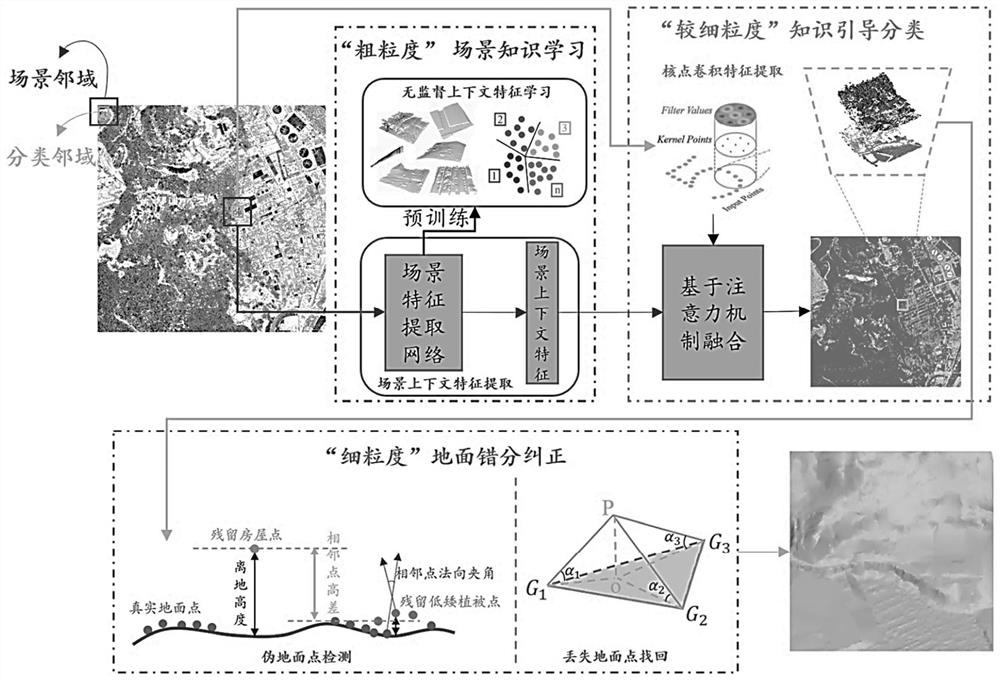
[0049] like figure 1 As shown, the inventive method mainly comprises the following steps:

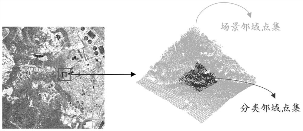
[0050] Step 1: Randomly select a sampling point in the whole point cloud, and use the sampling point as the center to search for a set of square scene neighborhood points with a side length of 150 meters and a group of square classification neighbors with a side length of 50 meters. set of domain points, such as figure 2 shown.

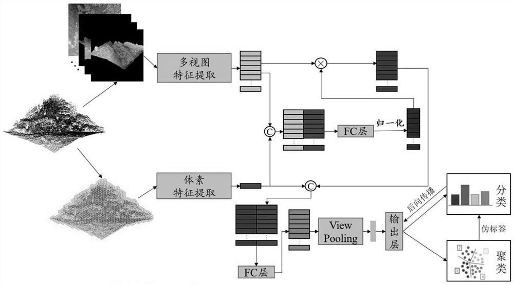
[0051] Step 2: In the way of unsupervised learning, train the global feature extraction model of point cloud, and extract the spatial context information (scene knowledge) from the large-scale scene neighborhood point set, so as to realize the coarse-grained large-scale scene perception. like image 3 shown, including the following sub-steps:

[0052] (1) Collect a large number of square point clouds with a side length of 150 meters containi...


PUM


Abstract

The invention proposes a multi-granularity calculation method for airborne laser point cloud classification in mixed scenes, which includes the steps of: selecting a classification neighborhood point set and a scene neighborhood point set with a sampling point as the center; training the point cloud global in an unsupervised learning manner The feature extraction model realizes coarse-grained scene perception; adopts the feature fusion strategy based on the attention mechanism, embeds the spatial context information in the point cloud semantic segmentation model, and defines a multi-task loss function that takes into account the ground clearance and the category. The category and height of each point in the domain point set are supervised to achieve finer-grained semantic segmentation of point clouds and prediction of height from the ground; through point cloud segmentation optimized based on graph cuts and iterative adsorption of ground irregular triangulation, fine-grained segmentation is achieved. Granularity of ground classification results refinement. The invention decomposes the classification problem of mixed scene point clouds into a combination of three relatively single problems, which effectively reduces the complexity of the whole problem and can realize robust and fine classification of point clouds of different complex scenes.

Description

technical field [0001] The invention belongs to the field of laser scanning data processing, and in particular relates to a multi-granularity calculation method for airborne laser point cloud classification in mixed scenes. Background technique [0002] Airborne Laser Scanning (ALS) is an important means to quickly acquire large-scale 3D geospatial data. It plays an important role in major national needs such as smart cities, global mapping, and global changes. It has been widely used in cities. 3D reconstruction, forestry survey, shallow sea bathymetry, archaeology of relics, deep space exploration and other national production or scientific research. As a key foundation for many applications of ALS systems, point cloud classification has a wide range of practical value. However, until now, this technology is still perplexing the industry and academia (the problem has not been completely solved), and has become a key bottleneck restricting the efficiency and automation of ...

Claims


Application Information

Patent Timeline
Patent Type & Authority Patents(China)
IPC IPC(8): G06V20/10G06V10/26G06V10/774G06V10/80G06V10/82G06K9/62G06N3/04
CPCG06N3/045G06F18/253G06F18/214
Inventor 秦楠楠
Owner ZIJINSHAN ASTRONOMICAL OBSERVATORY CHINESE ACAD OF SCI
Why Eureka
Try Eureka