
Method for realizing network dynamic geographic information service and device for realizing different network dynamic geographic information services

A geographic information service and geographic information technology, which is applied in the field of network dynamic geographic information service, can solve the problems of inability to distribute distributed deployment, unable to provide loose service providers and users, and difficult to realize automatic update requirements of geographic information data, etc. The effect of deploying and expanding the update

Active Publication Date: 2022-03-15
CHENGDU JOUAV AUTOMATION TECH
View PDF4 Cites 1 Cited by
  • Summary
  • Abstract
  • Description
  • Claims
  • Application Information

AI Technical Summary

Problems solved by technology

[0003] A real-time geographic information system needs a method that can realize dynamic update data services, but based on static data protocols such as WMS, WFS, and WCS, it is difficult to achieve dynamic geographic information data automatic update requirements
The existing technology can only realize the dynamic presentation layer and application layer, but cannot realize the dynamic data layer. Therefore, based on the existing technical solutions, real-time splicing of video to generate DOM and dynamic map services for applications such as real-time video vector and grid AR cannot be realized.
Although the existing geographic information system provides the ability to change data in real time, it does not form a B / S architecture that decouples the front and back ends, that is, the presentation layer, application layer and data layer are all coupled together, so that the application can only be performed on a single computer. It cannot be distributed and deployed, and it cannot maintain a loose relationship between service providers and users

Method used


Image

  • Method for realizing network dynamic geographic information service and device for realizing different network dynamic geographic information services
  • Method for realizing network dynamic geographic information service and device for realizing different network dynamic geographic information services
  • Method for realizing network dynamic geographic information service and device for realizing different network dynamic geographic information services

Examples


Embodiment 1

[0068] Based on the existing WMS protocol, it is impossible to represent the map data driver or the dynamic data source of the map, and it cannot meet the technical requirements such as configuration, start and stop of the map data driver when it is running. For applications such as real-time video splicing, the presentation layer, application layer, and data layer need to be decoupled, which consumes a lot of computing resources;

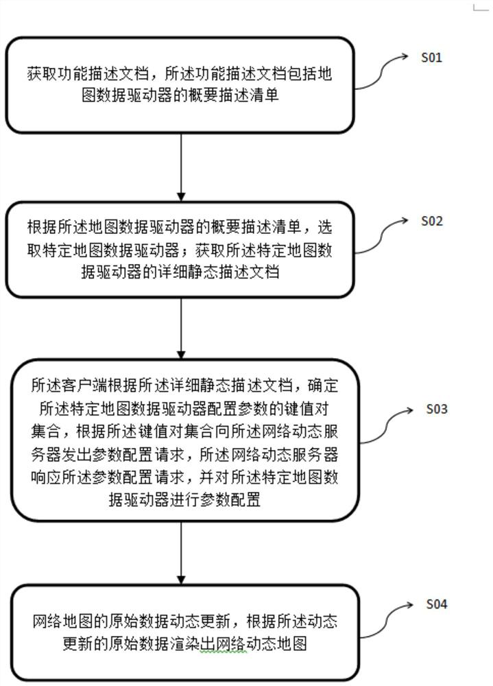
[0069] In order to solve the above problems, the present invention proposes to deploy and run program units that consume a large amount of computing resources on the back-end server, so that the presentation layer that only performs data presentation can run on the front-end browser, that is, a B / S architecture is formed, so that Applications can be distributed and deployed. The invention proposes a method and device for realizing network dynamic map service, and the device includes a network dynamic map server (WDMS Server) and a client.

[0070]...

Embodiment 2

[0159] In the process of acquiring full-motion video, the client needs to display the range of the sensor's field of view in real time on the map, which is represented as dynamically changing vector data; when performing AI detection and recognition in full-motion video, it needs to be dynamically drawn on the map Detection results, this requires strategic interaction mechanisms such as AI detection and recognition units, vector data generation units, and system control units to dynamically read and write incrementally generated vector data from the data set (library), realizing AI detection data. It is dynamically generated and modified, and the existing vector element update methods are difficult to meet the needs of browsers or clients for various dynamic updates of vector data.

[0160] The existing WFS protocol can only provide basic addition, deletion, query and modification functions for the update of vector data, but the collection and application of remote sensing data...

Embodiment 3

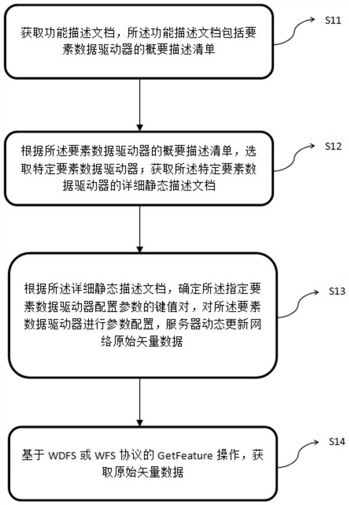
[0259] In this embodiment, the network dynamic map service is realized through the combination of the WMS protocol and the WDFS protocol. The specific implementation process is as follows, as Figure 4 Shown:

[0260] S21: Obtain a function description document, where the function description document includes a summary description list of element data drivers;

[0261] The GetCapabilities operation based on the WDFS protocol constructs a URL on the network client and initiates a request to the HTTP server through the HTTP protocol; after the HTTP server receives the request, it transmits the URL of the GetCapabilities operation through the CGI protocol and initiates a request to the WDFS server; the WDFS server parses the GetCapabilities operation URL, handle the request;

[0262] Further, the process of processing the GetCapabilities operation request inside the WDFS server:

[0263] First, the network request dispatcher WDFSDispatcher is responsible for parsing the URL of...


PUM


Abstract

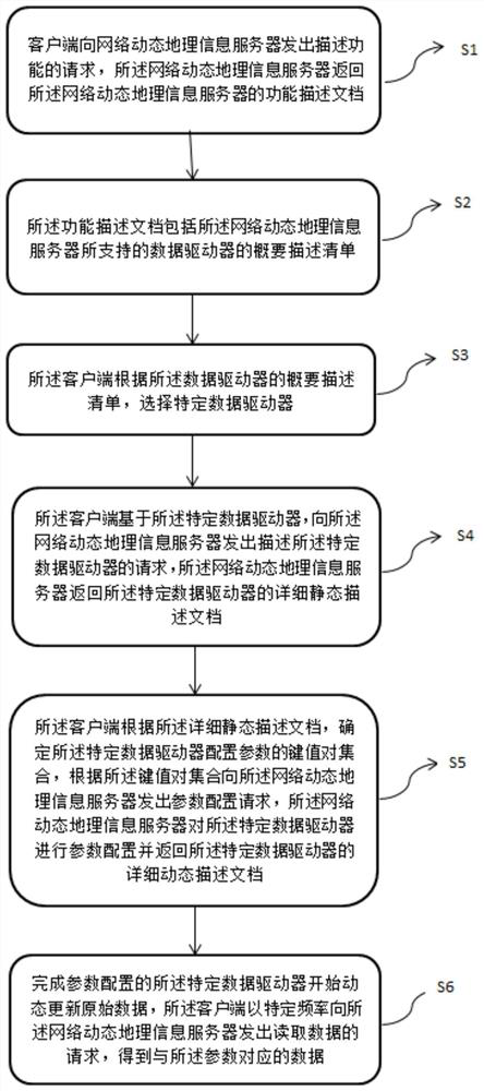
The invention discloses a method for realizing network dynamic geographic information service and a device for realizing different network dynamic geographic information services, which realize dynamic updating of original data of different types of geographic information by setting specific data drivers in different servers. The client requests to obtain the original data of the geographic information at a proper frequency, so that different network dynamic geographic information services can be realized; according to the invention, the protocol of the existing OGC network geographic information service is creatively expanded so as to realize the purpose of separating the front end and the rear end of the real-time dynamic geographic information system, that is, the main transaction logic with relatively high requirements on computer resources is realized in a rear-end server, and the simple transaction logic such as data access and data presentation is realized in a front-end client; therefore, a low coupling relationship between the service provider and the user is formed, and distributed deployment, expansion and updating of the service are facilitated.

Description

technical field [0001] The invention relates to the field of network dynamic geographic information services, in particular to a method for realizing network dynamic geographic information services and different devices for realizing network dynamic geographic information services. Background technique [0002] With the development of image data collection and application, the demand for real-time geographic information systems is gradually increasing. Compared with traditional geographic information systems, real-time geographic information systems have real-time data collection interfaces. From the perspective of geographic information databases, it is " The functions of adding, deleting, checking, and modifying data are automatic and real-time. [0003] Real-time geographic information system needs a method that can realize dynamic update data service, but based on WMS, WFS, WCS and other static data protocols, it is difficult to realize the automatic update requirement o...

Claims


Application Information

Patent Timeline
Patent Type & Authority Applications(China)
IPC IPC(8): G06F16/29
CPCG06F16/29G06F16/909G06F16/955
Inventor 刘夯韩丹梅华龙林兴元袁睿任鑫怡
Owner CHENGDU JOUAV AUTOMATION TECH
Learn More