Visual positioning method and system of unmanned aerial vehicle

A technology for visual positioning and drones, which is applied in image data processing, instruments, calculations, etc., can solve the problems of difficult to distinguish the position of drones, low accuracy of positioning methods, poor stability, etc., and achieve the goal of visual positioning Effect

Pending Publication Date: 2022-03-18
TECH & ENG CENT FOR SPACE UTILIZATION CHINESE ACAD OF SCI
View PDF5 Cites 0 Cited by
  • Summary
  • Abstract
  • Description
  • Claims
  • Application Information

AI Technical Summary

Problems solved by technology

UAV positioning generally uses GPS as the main means. However, when encountering GPS signal failure or weather reasons during long-distance navigation, it will be difficult for the system to determine the location of the UAV.
[0003] The existing UAV visual positioning scheme can be realized based on t

Method used


Image

  • Visual positioning method and system of unmanned aerial vehicle
  • Visual positioning method and system of unmanned aerial vehicle
  • Visual positioning method and system of unmanned aerial vehicle

Examples


Embodiment Construction

[0053] The principles and features of the present invention will be described below in conjunction with the accompanying drawings, and the examples given are only used to explain the present invention, and are not intended to limit the scope of the present invention.

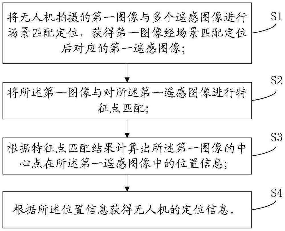
[0054] Such as figure 1 As shown, a visual positioning method for a drone provided in an embodiment of the present invention includes:

[0055] S1, performing scene matching and positioning on the first image captured by the UAV and multiple remote sensing images, and obtaining the corresponding first remote sensing image after the scene matching and positioning of the first image;

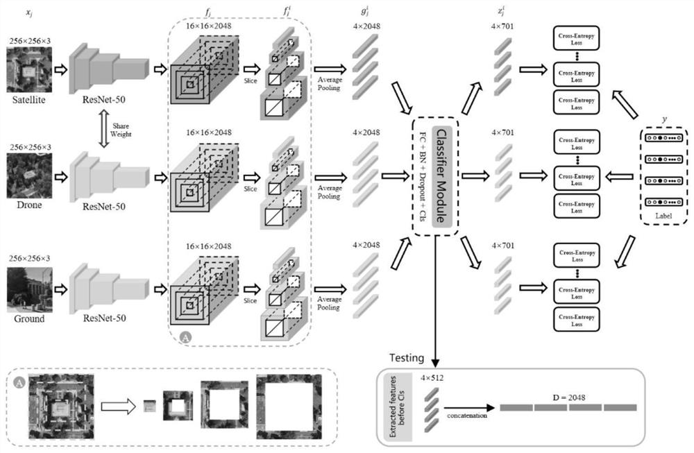
[0056] In a certain embodiment, the LPN algorithm is used to extract and classify the features of the UAV image and the remote sensing image, and find the best matching remote sensing image for each UAV image to realize scene positioning.

[0057] In another embodiment, scene positioning may include: firstly, the input UAV pictures...


PUM


Abstract

The invention discloses a visual positioning method and system of an unmanned aerial vehicle, and relates to the field of unmanned aerial vehicle positioning. The method comprises the following steps: performing scene matching positioning on a first image shot by an unmanned aerial vehicle and a plurality of remote sensing images to obtain a first remote sensing image corresponding to the first image after scene matching positioning, and performing feature point matching on the first image and the first remote sensing image to obtain a first remote sensing image; the position information of the center point of the first image in the first remote sensing image is calculated according to the feature point matching result, and the positioning information of the unmanned aerial vehicle is obtained according to the position information. According to the scheme, the unmanned aerial vehicle image and the remote sensing image are accurately matched based on the deep learning image matching algorithm, visual positioning of the unmanned aerial vehicle is achieved, and the positioning accuracy of the unmanned aerial vehicle is improved. And high-precision positioning of the unmanned aerial vehicle can be realized without relying on a GPS (Global Positioning System).

Description

technical field [0001] The invention relates to the field of UAV positioning, in particular to a visual positioning method and system for UAVs. Background technique [0002] With the continuous development of UAV technology, UAV positioning technology has received extensive attention. UAV positioning generally uses GPS as the main means. However, when encountering GPS signal failure or weather reasons during long-distance navigation, it will be difficult for the system to determine the location of the UAV. [0003] The existing UAV visual positioning scheme can be realized based on the improved SIFT matching method. The positioning method based on the SIFT algorithm has low precision and is difficult to meet the requirements of precise positioning; the algorithm based on image registration is difficult to deal with the scene where the ground information is scarce. Less stable. Contents of the invention [0004] The technical problem to be solved by the present invention ...

Claims


Application Information

Patent Timeline
IPC IPC(8): G06T7/73
CPCG06T7/74G06T2207/10032G06T2207/20081G06T2207/20084G06T2207/20016
Inventor 蔚伟鹏万雪
Owner TECH & ENG CENT FOR SPACE UTILIZATION CHINESE ACAD OF SCI
Why Eureka
Try Eureka