Multi-level real-time fusion updating method for multi-source traffic GIS road network

An update method, multi-level technology, applied in special data processing applications, structured data retrieval, geographic information databases, etc., can solve the problems of data not mining in time, data incompatibility, and many data models, etc., to enhance the current situation and Accuracy, fast update speed, and the effect of improving the current situation

Pending Publication Date: 2022-03-25
魏存可
View PDF0 Cites 3 Cited by
  • Summary
  • Abstract
  • Description
  • Claims
  • Application Information

AI Technical Summary

Problems solved by technology

[0012] For vector data, the real-time fusion application and update of data from coarse level (point, line object) to fine level (actual lane) has not been realized, the data has not been mined in time, the corresponding relationship between the data model level is lacking, and it cannot meet the OGC standard. To solve problems such as accessing different data service providers, this application proposes a multi-level real-time fusion update method for multi-source road network vectors. The multi-level real-time fusion model of the vector road network improves the data model of its classification definition at the level of detail, and designs a multi-level real-time fusion framework; the second is that the data coordinate system of different data sources is inconsistent with the map pr

Method used


Image

  • Multi-level real-time fusion updating method for multi-source traffic GIS road network
  • Multi-level real-time fusion updating method for multi-source traffic GIS road network
  • Multi-level real-time fusion updating method for multi-source traffic GIS road network

Examples


Embodiment Construction

[0102] The following is a further description of the technical solution of the multi-level real-time fusion update method for the multi-source traffic GIS road network set by the application in conjunction with the accompanying drawings, so that those skilled in the art can better understand the application and implement it.

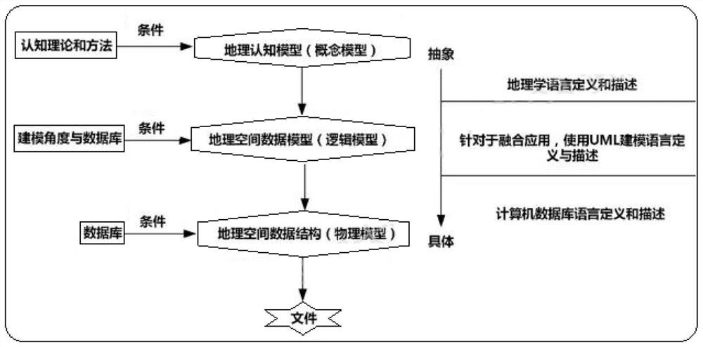
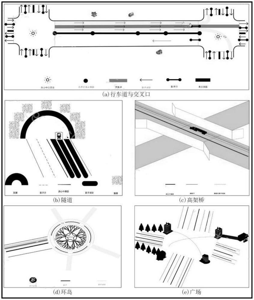
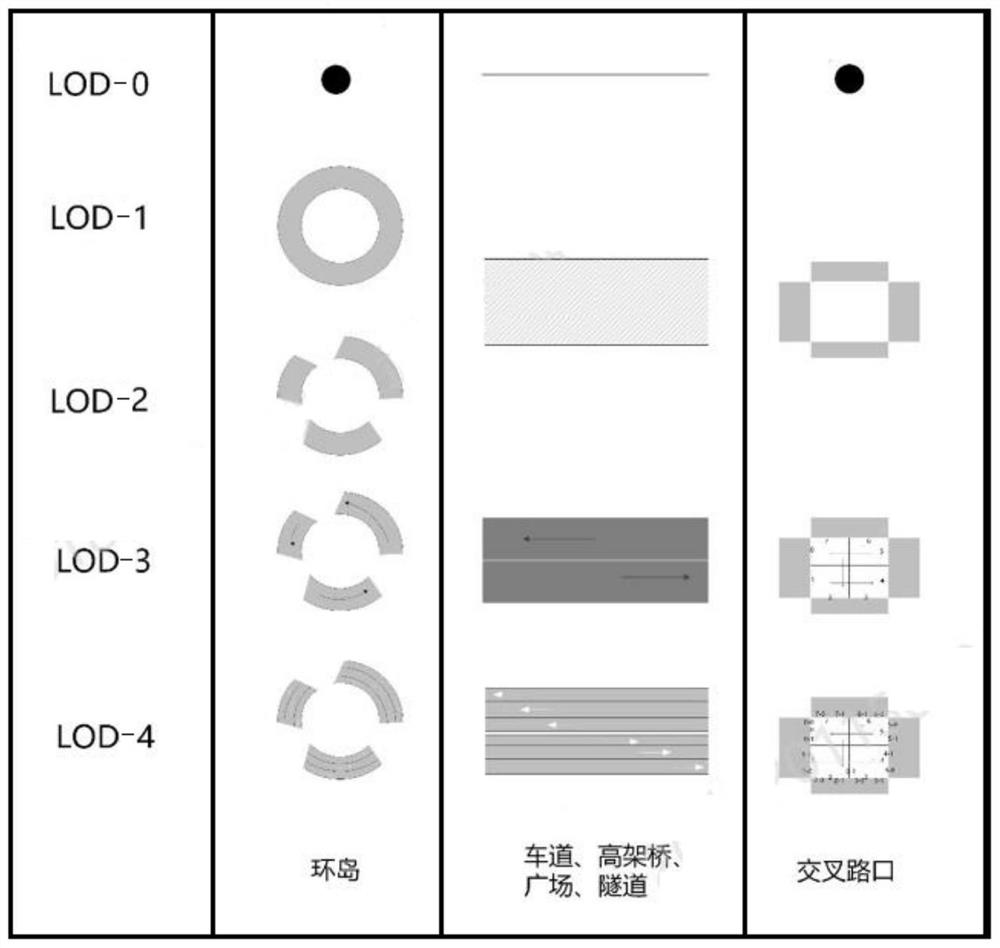
[0103] At present, the vector data represented by basic geographic data, AutoNavi, Baidu and other navigation data have not really realized the real-time fusion application and update of data from coarse level (point, line object) to fine level (actual lane). Aiming at the problems of untimely mining of data, lack of data model level correspondence, and inability to meet different data service providers based on the OGC standard, this application proposes a multi-source road network vector multi-level real-time fusion update method. mainly includes:

[0104] (1) Aiming at the problems of numerous existing data models and data incompatibility with each ot...


PUM


Abstract

The invention provides a five-layer data fusion model based on CityGML for the application requirement of high-precision vector data fusion, and realizes a multi-level real-time fusion updating method covering a traffic GIS road network. Firstly, a multi-level, object-oriented and lane-level fusion model based on the OGC standard is provided, the model is defined and described on the concept level, the logic level and the physical level, and the geometry, the semantics and the topology related to the model are completely explained; 2, designing an adaptive data fusion method, and realizing clustering analysis, linearization and topology reconstruction of the probe vehicle, clustering analysis-based vector road network matching of a vector road network and position and semantic approximation information-based fusion of POI data; thirdly, an LOD-s model management module is integrally designed; experimental results show that the tool meets the requirement of multivariate vector data fusion, and compared with manual self-adaptive fusion, the efficiency can be greatly improved on the premise of meeting multiple levels and high precision.

Description

technical field [0001] The present application relates to a real-time fusion update method of a GIS road network, in particular to a multi-level real-time fusion update method of a multi-source traffic GIS road network, which belongs to the technical field of multi-level fusion of traffic road networks. Background technique [0002] With the process of urbanization and the rapid development of the transportation industry, the road network is becoming more and more complex, and the information of various road traffic networks presents the characteristics of hugeness, diversity and complexity. At the same time, the requirements for road networks in various fields are becoming increasingly refined, and different levels of industries show different levels of detail for road networks. At this stage, the more detailed expression and simulation of the huge traffic vector data at a more microscopic level (sub-meter level) has been put into application. Fine (sub-meter level) road n...

Claims


Application Information

Patent Timeline
IPC IPC(8): G06F16/29
CPCG06F16/29
Inventor 魏存可
Owner 魏存可
Why Eureka
Try Eureka