Method and device for managing and controlling spatial data in user-defined range

A spatial data and self-defined technology, applied in the field of data processing, can solve problems such as increased cost, client maintenance, inconvenient update token, difficulty in distinguishing different user roles, etc., and achieve the effect of avoiding maintenance

Pending Publication Date: 2022-03-25
上海数慧系统技术有限公司
View PDF0 Cites 1 Cited by
  • Summary
  • Abstract
  • Description
  • Claims
  • Application Information

AI Technical Summary

Problems solved by technology

[0006] In view of this, the present invention provides a method and device for managing and controlling spatial data in a self-defined range, which is used to solve the problem of controlling authority through the token mechanism in the prior art, but for the application system, it is difficult to distinguish different user roles, and at the same time It is also inconvenient for the client to maintain and update the token; or by adding the administrative area field to the data and controlling it through field screening, it adds a lot of cost to data production, update, and maintenance. At the same time, it is helpless for slice services and image data. If the data is divided according to the administrative region, it will cause data fragmentation and redundancy problems

Method used


Image

  • Method and device for managing and controlling spatial data in user-defined range
  • Method and device for managing and controlling spatial data in user-defined range

Examples


Embodiment Construction

[0064] The following will clearly and completely describe the technical solutions in the embodiments of the present invention with reference to the accompanying drawings in the embodiments of the present invention. Obviously, the described embodiments are only some, not all, embodiments of the present invention. Based on the embodiments of the present invention, all other embodiments obtained by persons of ordinary skill in the art without making creative efforts belong to the protection scope of the present invention.

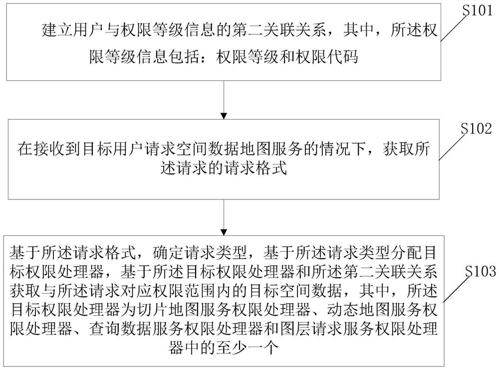
[0065] The invention discloses a method and device for managing and controlling spatial data in a self-defined range, which is applied in the process of managing and controlling spatial data of a geographic information system (GIS) (Geographic Information System). At present, security control of spatial data is usually carried out from two dimensions:

[0066] (1) To share spatial data in the form of map services, since some sensitive data is often involved, it...


PUM


Abstract

The invention discloses a method and device for managing and controlling spatial data in a customized range, and the method comprises the steps: building a first incidence relation between authority level information and authority range coordinates, building a second incidence relation between a user and the authority level information, and obtaining a request format of a request under the condition that a target user requests a spatial data map service; and determining a request type based on the request format, allocating a target permission processor based on the request type, and obtaining target spatial data in a permission range corresponding to the request based on the target permission processor and the second association relationship. The spatial data is managed and controlled by establishing the incidence relation between the permission level information and the user and permission range coordinates, a token mechanism and a field screening mode are not adopted any more to control permissions, slicing services and image data do not need to be segmented, the problems of inconvenience in client maintenance and token updating, data fragmentation and redundancy are avoided, and the user experience is improved. And the cost of data production, updating and maintenance is reduced.

Description

technical field [0001] The invention relates to the technical field of data processing, in particular to a method and device for managing and controlling spatial data within a custom range. Background technique [0002] In the process of planning information construction, the GIS system pays more and more attention to the security and authority control of spatial data and services. At present, security control of spatial data is usually carried out from two dimensions: [0003] (1) To share spatial data in the form of map services, since some sensitive data are often involved, we do not want the service to be accessed and used by everyone; [0004] (2) After the service is shared, it is necessary to control the authority of users according to the administrative area unit (spatial range). For example, users of the city bureau can access the data of the whole city, users of the district bureau can only access the data of the district, and users of the street and town can only...

Claims


Application Information

Patent Timeline
Patent Type & Authority Applications(China)
IPC IPC(8): G06F21/45G06F16/29
CPCG06F21/45G06F16/29G06F21/1014
Inventor 胡飞玲罗亚杨龙王东辉杨海刚白富权张耘逸李静
Owner 上海数慧系统技术有限公司
Why Eureka
Try Eureka