Real-time geometric calibration method for internal and external orientation elements of remote sensing satellite

A technology of internal and external orientation elements and geometric calibration, which is applied in the field of real-time geometric calibration of internal and external orientation elements of remote sensing satellites, can solve the problems of low calibration efficiency, poor applicability, long period, etc., to overcome low efficiency, improve calibration efficiency and The effect of image geometric positioning accuracy

Active Publication Date: 2022-03-25
AEROSPACE INFORMATION RES INST CAS
View PDF17 Cites 1 Cited by
  • Summary
  • Abstract
  • Description
  • Claims
  • Application Information

AI Technical Summary

Problems solved by technology

[0005] The invention provides a real-time geometric calibration method for the internal and external orientation elements of remote sensing satellites, which is used to solve the defects of low calibration efficiency, long cycle and poor applicability in the prior art, and realize real-time, automatic and high-precision geometric calibration

Method used


Image

  • Real-time geometric calibration method for internal and external orientation elements of remote sensing satellite
  • Real-time geometric calibration method for internal and external orientation elements of remote sensing satellite
  • Real-time geometric calibration method for internal and external orientation elements of remote sensing satellite

Examples


Embodiment Construction

[0035] In order to make the purpose, technical solutions and advantages of the present invention clearer, the technical solutions in the present invention will be clearly and completely described below in conjunction with the accompanying drawings in the present invention. Obviously, the described embodiments are part of the embodiments of the present invention , but not all examples. Based on the embodiments of the present invention, all other embodiments obtained by persons of ordinary skill in the art without creative efforts fall within the protection scope of the present invention.

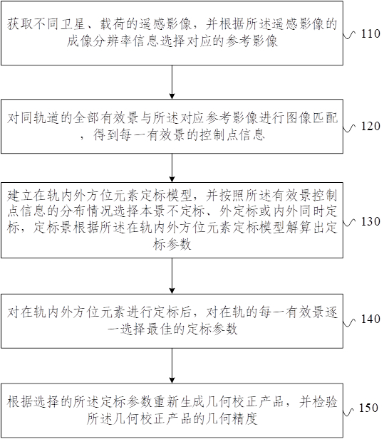
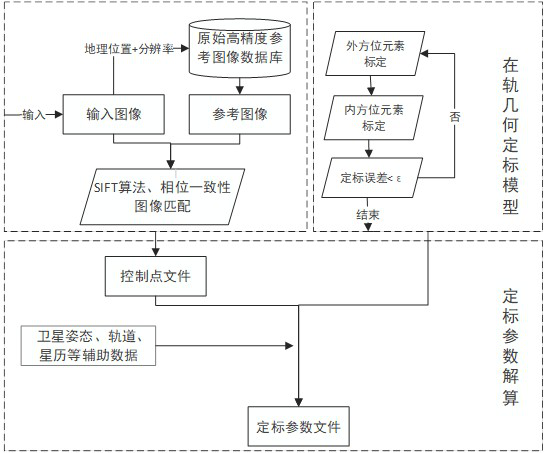
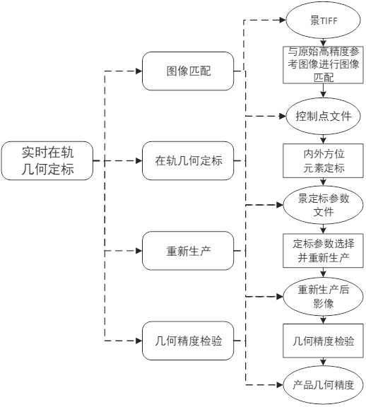
[0036] Combine below Figure 1-Figure 3 Describe the real-time geometric calibration method of the remote sensing satellite internal and external azimuth elements of the present invention:

[0037] refer to figure 1 , the real-time geometric calibration method of the remote sensing satellite internal and external azimuth elements provided by the present invention comprises the following ste...


PUM


Abstract

The invention provides a real-time geometric calibration method for internal and external orientation elements of a remote sensing satellite, which comprises the following steps: acquiring remote sensing images of different satellites and loads, and selecting corresponding reference images according to imaging resolution information of the remote sensing images; performing image matching on all the effective scenes in the same track and the corresponding reference image to obtain a control point of each effective scene; establishing an in-orbit internal and external orientation element calibration model, selecting local scene indefinite calibration, external calibration or internal and external simultaneous calibration according to the distribution condition of effective scene control points, and calculating calibration parameters of the calibration scene according to the in-orbit internal and external orientation element calibration model; after on-orbit internal and external orientation elements are calibrated, optimal calibration parameters are selected for each on-orbit effective scene one by one; and regenerating a geometric correction product according to the selected calibration parameters, and checking the geometric accuracy of the geometric correction product. According to the invention, the calibration efficiency and the geometric positioning precision of the image are improved.

Description

technical field [0001] The invention relates to the technical field of remote sensing satellites, in particular to a real-time geometric calibration method for internal and external azimuth elements of a remote sensing satellite. Background technique [0002] The function of remote sensing satellite on-orbit geometric calibration is to provide accurate camera imaging parameters for geometric processing of images, which is the basis for systematic geometric correction of images and plays an important role in ensuring the geometric quality of images. [0003] At present, there are two main methods used for geometric calibration of remote sensing satellites: one is the calibration method based on the ground geometric calibration field; the other is to select high-precision reference data and obtain dense control points through manual point selection or image matching. Scaling of inside and outside orientation elements. Both methods select only typical areas, monitor calibratio...

Claims


Application Information

Patent Timeline
Patent Type & Authority Applications(China)
IPC IPC(8): G06T7/80G06T5/00G06V20/13G06V10/74
CPCG06T7/80G06T5/006G06F18/22
Inventor 李景山程玉芳
Owner AEROSPACE INFORMATION RES INST CAS
Why Eureka
Try Eureka