Ocean course safety assessment method based on marine environment information
A marine environment and safety assessment technology, applied in the field of navigation, can solve problems such as ship collisions and poor visual conditions, and achieve the effect of improving accuracy and improving program efficiency
- Summary
- Abstract
- Description
- Claims
- Application Information
AI Technical Summary
Problems solved by technology
Method used
Image
Examples
Embodiment 1
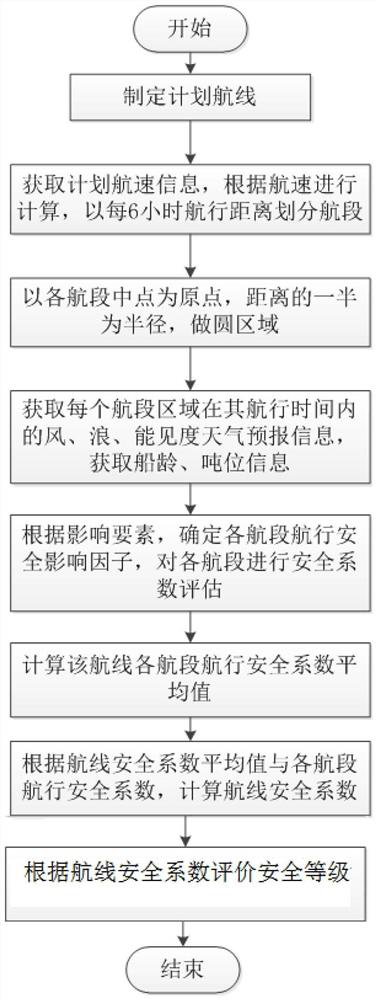
[0067] Such as figure 1 As shown, a safe assessment method based on marine environment information, including the following steps:
[0068] Step 1. Develop a container ship plan route, the plan route consists of 2 voyage sections, the starting point of the route is P 0 (19.0 ° N, 136.2 ° E), route point (20.73 ° N, 140.1 ° E), the end point is P n (21.4 ° N, 144.5 ° E), the total distance of the route is 742.3 sea, starting time t 0 (Beijing time November 1, 2021, 8:00), arrived at time t n (Beijing time November 3, 2021), 6: 24).
[0069] Step 2, starting point P 0 (19.0 ° N, 136.2 ° e) is the starting point, planned speed limit 16 sessions, calculated according to the planned speed, saving a segment every 6 hours, a total of 8 segments. N = 8.
[0070] Segment D 1 Arrival point is P 1 And arrived time is T 1 (Beijing time November 1, 14: 00), 14:00), distance s 1 = 96 sea, the average speed is V 1 = 16.
[0071] Segment D 2 Arrival point is P 2 And arrived time is T 2 (Beijing t...
PUM
 Abstract
Description
Claims
Application Information
 - R&D
- Intellectual Property
- Life Sciences
- Materials
- Tech Scout
- Unparalleled Data Quality
- Higher Quality Content
- 60% Fewer Hallucinations
Browse by: Latest US Patents, China's latest patents, Technical Efficacy Thesaurus, Application Domain, Technology Topic, Popular Technical Reports.
© 2025 PatSnap. All rights reserved.Legal|Privacy policy|Modern Slavery Act Transparency Statement|Sitemap|About US| Contact US: help@patsnap.com


