Satellite-borne GNSS-R high-precision soil moisture estimation method based on CYGNSS data

A soil moisture and high-precision technology, which is applied in water resources assessment, material analysis, soil material testing, etc., can solve problems such as the lack of system correction and the need to further improve the estimation accuracy of soil moisture, so as to optimize the estimation model and improve the estimation accuracy Effect

Active Publication Date: 2022-04-19
INST OF GEOGRAPHICAL SCI & NATURAL RESOURCE RES CAS +1
View PDF7 Cites 7 Cited by
  • Summary
  • Abstract
  • Description
  • Claims
  • Application Information

AI Technical Summary

Problems solved by technology

However, the currently publicly released CYGNSS soil moisture products have not been systematically corrected, and have no...

Method used


Image

  • Satellite-borne GNSS-R high-precision soil moisture estimation method based on CYGNSS data
  • Satellite-borne GNSS-R high-precision soil moisture estimation method based on CYGNSS data
  • Satellite-borne GNSS-R high-precision soil moisture estimation method based on CYGNSS data

Examples


Embodiment Construction

[0032] In order to make the purpose, technical solutions and advantages of the embodiments of the present invention clearer, the technical solutions in the embodiments of the present invention will be clearly and completely described below in conjunction with the drawings in the embodiments of the present invention. Obviously, the described embodiments It is a part of embodiments of the present invention, but not all embodiments. Based on the embodiments of the present invention, all other embodiments obtained by persons of ordinary skill in the art without making creative efforts belong to the protection scope of the present invention.

[0033] In order to facilitate the understanding of the embodiments of the present invention, further explanations will be given below with specific embodiments in conjunction with the accompanying drawings, which are not intended to limit the embodiments of the present invention.

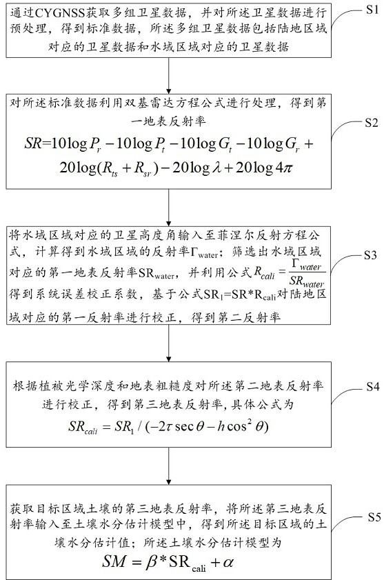
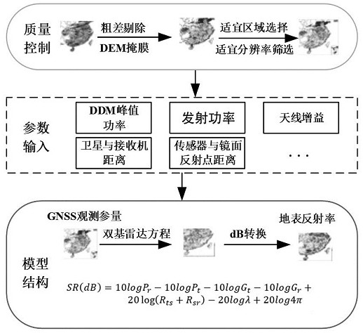
[0034] The embodiment of the present invention provides a spa...


PUM


Abstract

The invention relates to a satellite-borne GNSS-R high-precision soil moisture estimation method based on CYGNSS data, and the method comprises the steps: obtaining a plurality of groups of satellite data through CYGNSS, and carrying out the preprocessing of the data, and obtaining standard data; processing the standard data by using a bistatic radar equation to obtain a first surface reflectance; inputting a satellite elevation angle corresponding to the water area into a Fresnel reflection equation, and calculating to obtain a reflectivity gamma water; screening out a first surface reflectance SRwater of the water area, obtaining a system error correction coefficient by using a formula, and correcting the first reflectance of the land area based on a formula SR1 = SR * Rcali to obtain a second reflectance; correcting the second surface reflectance according to the vegetation optical depth and the surface roughness to obtain a third surface reflectance; acquiring a third surface reflectance of the soil in the target area, and inputting the third surface reflectance into the soil moisture estimation model to obtain a soil moisture estimation value of the target area; according to the invention, a method for correcting system errors, surface roughness and vegetation is provided through CYGNSS data, and the soil moisture estimation precision is improved.

Description

technical field [0001] The invention relates to the technical field of hydrological remote sensing. Specifically, it involves a high-precision soil moisture estimation method based on spaceborne GNSS-R based on CYGNSS data. Background technique [0002] Soil moisture is an important component in processes such as hydrological processes, surface evapotranspiration, water migration, and carbon cycling. Remotely sensed soil moisture products with high accuracy and high spatio-temporal resolution are necessary inputs for such applications. Global soil moisture retrieval has been a research topic in the fields of optical remote sensing and microwave remote sensing. Optical remote sensing data has high spatial resolution (such as MODIS), but is limited by clouds and fog. In addition, optical remote sensing only develops models for estimating soil moisture, and there are no official soil moisture products. In contrast, microwave sensors provide all-day capability for remote sen...

Claims


Application Information

Patent Timeline
IPC IPC(8): G01N23/00G01N33/24G06V20/13
CPCG01N23/00G01N33/246Y02A90/30
Inventor 杨婷孙志刚
Owner INST OF GEOGRAPHICAL SCI & NATURAL RESOURCE RES CAS
Why Eureka
Try Eureka