
Identification point location selection method considering topographic features

A technology of terrain features and identification points, which is applied in the field of terrain survey and can solve the problems of high labor cost and lengthy construction period.

Pending Publication Date: 2022-04-19
重庆市勘测院((重庆市地图编制中心)
View PDF0 Cites 0 Cited by
  • Summary
  • Abstract
  • Description
  • Claims
  • Application Information

AI Technical Summary

Problems solved by technology

[0004] Aiming at the deficiencies of the existing technology, the present invention proposes a location selection method for marking points that takes into account the terrain characteristics, so as to solve the problem in the prior art that manual site selection analysis is used for the marking points when performing boundary marking, resulting in labor costs Costly and lengthy technical issues

Method used


Image

  • Identification point location selection method considering topographic features
  • Identification point location selection method considering topographic features
  • Identification point location selection method considering topographic features

Examples


Embodiment 1

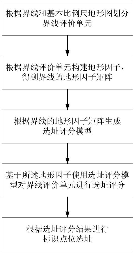
[0041] This embodiment provides a method of location selection for marking points that takes into account topographic features, such as figure 1 shown, including the following steps:

[0042] S1. According to the boundary line and the basic scale topographic map, divide the boundary line evaluation unit

[0043] S1-1. Generate an irregular triangular network model based on the basic scale topographic map, and use the irregular triangular network to express the digital elevation of the boundary area

[0044] Triangulated Irregular Network (TIN) models use a series of connected triangles to fit earth or other irregular surfaces. In a specific embodiment, the TIN model is generated by using the basic scale topographic map and its digitized products (such as DEM). Preferably, in this embodiment, the elevation tolerance value of the TIN model generated from the DEM is given as follows: 3 meters for flat land and hilly land; 10 meters for mountainous land and high mountain land. ...

Embodiment 2

[0069] An electronic device is provided, comprising:

[0070] one or more processors;

[0071] storage means for storing one or more programs;

[0072] When one or more programs are executed by one or more processors, the one or more processors are made to implement the method for addressing marker points in consideration of terrain features provided by Embodiment 1.

[0073] The electronic device provided by this embodiment solves the technical problem and achieves the same technical effect as that of Embodiment 1.


PUM


Abstract

The invention provides an identification point location selection method considering topographic features. The method comprises the following steps: dividing boundary evaluation units according to a boundary and a basic scale topographic map; constructing topographic factors according to the boundary evaluation unit to obtain a topographic factor matrix of the boundary; generating a site selection scoring model according to the terrain factor matrix of the boundary line; performing site selection scoring on the boundary evaluation unit by using a site selection scoring model based on the terrain factors; and carrying out identification point location site selection according to a site selection scoring result. According to the method, the technical problems of high labor cost and long construction period caused by adopting manual site selection analysis on the identification point location during boundary line identification can be solved; manual intervention can be reduced, site selection cost is reduced, and the construction period is shortened.

Description

technical field [0001] The invention relates to the technical field of topographical surveying, in particular to a location selection method for marking points in consideration of topographic features. Background technique [0002] In topographical surveying, when marking the boundary line, markers such as boundary posts and signboards need to be set up in a certain way along the boundary line; site selection and analysis of the marking points need to be carried out before the marking is established. [0003] At present, the site selection of marking points is often done through manual analysis in the industry and field surveys in the field. The constraints of the topographical conditions in the boundary area lead to a huge workload, high labor costs, and long construction periods when using traditional methods for site selection of marking points. Contents of the invention [0004] Aiming at the deficiencies of the existing technology, the present invention proposes a lo...

Claims


Application Information

Patent Timeline
Patent Type & Authority Applications(China)
IPC IPC(8): G06T17/05G06Q10/06G06F17/16
CPCG06T17/05G06F17/16G06Q10/06393
Inventor 陈良超周智勇马红胡开全贺瑜琦李晗
Owner 重庆市勘测院((重庆市地图编制中心)
Learn More