
Differential satellite navigation system of ship-based unmanned aerial vehicle

A satellite navigation system and unmanned aerial vehicle (UAV) technology, which is applied in the field of shipboard UAV landing navigation, can solve the problems of affecting the guidance accuracy, hull swaying, and shipboard landing accuracy, so as to improve the accuracy of heading measurement and mature application Effect

Pending Publication Date: 2022-04-26
BEIHANG UNIV +1
View PDF0 Cites 0 Cited by
  • Summary
  • Abstract
  • Description
  • Claims
  • Application Information

AI Technical Summary

Problems solved by technology

However, the length of the ship’s deck is limited, which leads to extremely high precision requirements for shipboard landing, and the ship always moves when performing tasks at sea. The landing difficulty of man-machine carrier

Method used


Image

  • Differential satellite navigation system of ship-based unmanned aerial vehicle
  • Differential satellite navigation system of ship-based unmanned aerial vehicle
  • Differential satellite navigation system of ship-based unmanned aerial vehicle

Examples


Embodiment

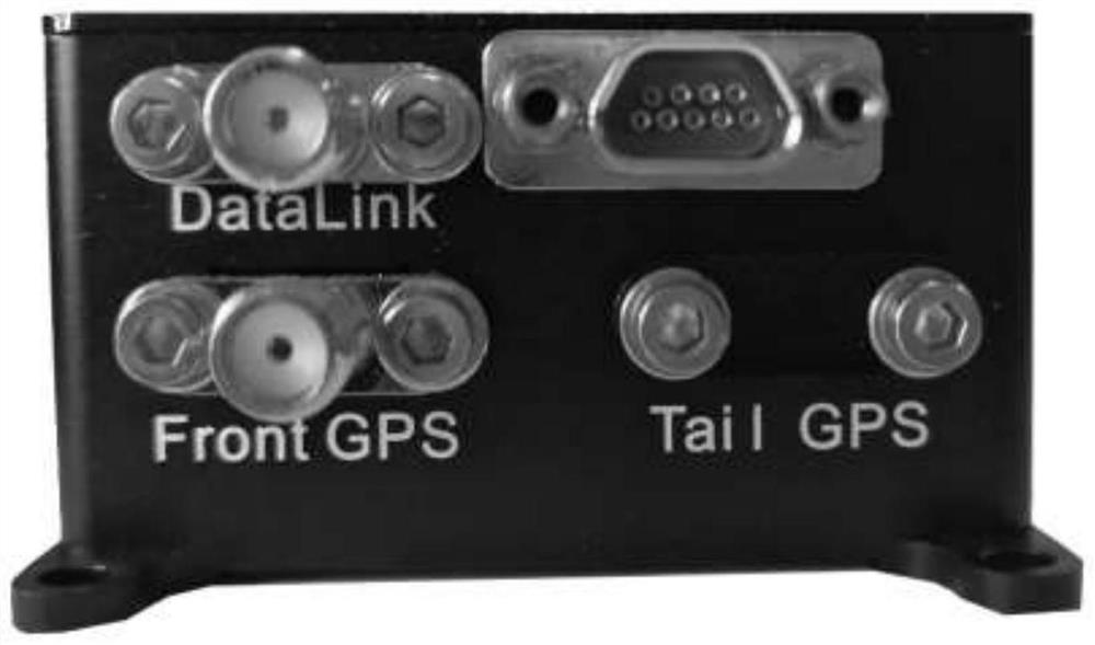
[0072] The GD30 differential satellite navigation system has two packaging forms: the smaller housing (93×52mm, collectively referred to as M package) is generally used for mobile stations, but in the case of dynamic differential or ground requirements to access dual antennas, the ground terminal also The case will be used as the package. like figure 1 As shown, there are 4 Ф3.2mm mounting holes with a pitch of 87mm×46mm. Users can directly use these mounting holes to fix the GD30. Larger housings (125×133, collectively referred to as L packages) are generally only used for reference stations, and have four Ф4mm mounting holes with a hole distance of 125mm×133mm, such as figure 2 As shown, the user can directly use the mounting hole to fix the GD30 reference station. Regardless of the package of GD30, there is no installation direction requirement.

[0073] GD30 uses the chip STM32F103 as the CPU, such as image 3 As shown, Front GPS and Tail GPS are GPS antenna interface...


PUM


Abstract

The invention provides a differential satellite navigation system of a ship-based unmanned aerial vehicle, and belongs to the field of landing navigation of ship-based unmanned aerial vehicles. The system specifically comprises a GD30 differential satellite navigation system, and a positioning and orientation board card is provided with double antennas for orientation; the external inertial navigation device obtains attitude speed course information of the ship; the CPU carries out resolving fusion on the position of the ship and the course information of the double antennas, the relative position of the ship and the double antennas is calculated by introducing a dynamic-to-dynamic differential relative positioning technology, and finally, attitude information such as the relative position of the unmanned aerial vehicle and the ship, the course and the speed of the ship and the like is transmitted back to a radio station according to a protocol for remote output; meanwhile, the ship speed is introduced to serve as feedforward of the expected speed of the unmanned aerial vehicle, a PID controller added with the speed feedforward is designed, and then the response speed of the unmanned aerial vehicle for tracking the ship is obviously increased. According to the invention, high-precision ship surface information transmission and accurate relative position and speed transmission of the ship and the unmanned aerial vehicle are ensured, and high-precision taking-off and landing of the ship-based unmanned aerial vehicle mobile platform are realized.

Description

technical field [0001] The invention belongs to the field of ship-borne UAV landing navigation, in particular to a differential satellite navigation system for a ship-borne UAV. Background technique [0002] Shipborne UAVs refer to aircraft carriers, frigates, destroyers and other surface ships as bases, which can be reusable aircraft that are remotely controlled by ship operators or complete the entire process of flight tasks in a fully autonomous manner, also known as shipborne unmanned aerial vehicles. aircraft. In naval warfare, carrier-based UAVs are used to perform tasks such as early maritime reconnaissance, air early warning, relay communication, and long-range strikes, or to perform tasks such as electronic countermeasures, aerial refueling, and long-range bombing. [0003] Compared with traditional manned carrier-based aircraft, carrier-based UAVs are smaller, more autonomous, have more flexible combat capabilities, have good stealth performance, can ignore the li...

Claims


Application Information

Patent Timeline
Patent Type & Authority Applications(China)
IPC IPC(8): G01S19/55G01S19/52G01S19/49G01C21/16
CPCG01S19/55G01S19/52G01S19/49G01C21/165
Inventor 王松骈学超王宇宁谢嘉轩赵亦涵毛浩付仁皓张楠
Owner BEIHANG UNIV
Learn More